11:15 AM | ***Powerful winds late tonight into early Friday associated with the arrival and passage of a strong cold front…strong winds return on Saturday with follow-up system***
Paul Dorian

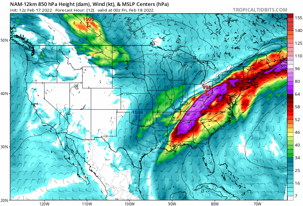
A very strong low-level jet will intensify in the overnight hours over the Mid-Atlantic/NE US and it could result in damaging wind gusts along coastal sections from Virginia-to-Maine. Maps courtesy NOAA, tropicatidbits.com
Overview
There will be very active weather from later tonight into early Friday in the Mid-Atlantic/Northeast US associated with the approach and passage of a strong cold frontal system. Temperatures are surging today ahead of the strong cold front and showers will become numerous from later tonight into early Friday and there can be a strong thunderstorm or two mixed into the picture. Of more concern, however, is the likelihood for powerful winds and there can be potentially damaging wind gusts; especially, in the time period surrounding the arrival and passage of the strong cold front. In the hour or so immediately behind the frontal passage, the pressure will spike, winds will shift in direction, and gusts can reach their highest levels. Temperatures will drop through the day on Friday after early day highs and the winds will die down tomorrow night. A reinforcing shot of cold arrives on Saturday and it will be supported by a very strong upper-level disturbance resulting in scattered snow showers/squalls and wind gusts past 40 mph.

This 1AM surface forecast map by the 12Z NAM model shows the location of the surface cold front. Map courtesy NOAA/WPC, tropicaltidbits.com
Details
Low pressure and its associated strong cold front will produce a wide range of conditions during the next couple of days ranging from highs winds to substantial accumulating snow to severe weather. The heaviest snowfall will extend from Kansas-to-northern Maine over the next 12-24 hours with quite an impact in the metro regions of Kansas City, St. Louis, Chicago and Detroit.
In the warm sector, the threat for severe weather will be greatest later today and early tonight in the Tennessee Valley region; specifically, in the zone between around Nashville, Tennessee to Huntsville, Alabama to southern Mississippi - and this threat includes the possibility of isolated tornadoes.

Severe weather is a threat later today into tonight and an “enhanced” risk extends from around Nashville, TN to Huntsville, AL. The severe weather threat includes the possibility of isolated tornadoes. Map courtesy NOAA/SPC
In the Mid-Atlantic/Northeast US, the biggest concern with this active frontal system will be the winds which will increase in strength today and then become quite powerful - and potentially damaging - late tonight into early Friday. During the afternoon, wind gusts are likely to reach the 30-40 mph range and then there can be a lull during the early evening hours. Later tonight, a low-level jet will increase noticeably in strength from a southwesterly direction and this is a cause of concern with respect to the potential of damaging wind gusts. In the worst case scenario, projections suggest winds can increase to 60+ mph late tonight into early Friday; especially, along the eastern seaboard from Virginia-to-Maine and scattered power outages are certainly on the table.

NOAA’s “weather warnings” map is full of different colors today - which is not a good thing. The “brown” is associated with “high wind watches” and this threat extends from Texas to Maine and the “yellow” is associated with tornado watches. Map courtesy NOAA/SPC
Perhaps the time of greatest concern will be the hour or two immediately following the passage of the strong surface cold front as there should be a surge in pressure and a shift in direction to the west-northwest. Sometimes mixing in the atmosphere becomes more efficient in this time period immediately following the passage of the surface cold front. The timing of the frontal passage in the immediate DC-to-Philly-to-NYC corridor is likely to be somewhere between 3 and 9 AM.

Winds will become very strong late tonight and early Friday in the Mid-Atlantic/Northeast US associated with the arrival and passage of a strong cold front. A reinforcing shot of cold air will arrive on Saturday and it will come with very strong support in the upper part of the atmosphere. As a result, scattered snow showers and even snow squalls will form on Saturday in the northeastern states and winds of 40+ mph are quite likely to develop. Map courtesy NOAA, tropicaltidbits.com
Following the frontal passage, temperatures are going to drop during the day on Friday after early day highs with the very strong winds of the early morning easing somewhat in the afternoon. A reinforcing shot of cold air arrives on Saturday and while its available moisture will be limited, it will be supported by a vigorous wave aloft. As a result, numerous snow showers will likely develop in the northeastern quadrant of the nation and there can be scattered heavier snow squalls. In addition, winds will become quite strong during the day on Saturday with gust of 40+ mph likely in the DC-to-Philly-to-NYC corridor.
Meteorologist Paul Dorian
Arcfield
arcfieldweather.com
Follow us on Facebook, Twitter, YouTube
Video discussion: