
11:30 AM | ****Temperatures to tumble tonight in the Mid-Atlantic…wintry mess from later tomorrow into early Friday…snow at the onset in some areas...significant ice buildup possible in many areas****
Paul Dorian

Temperatures will tumble tonight from today’s unusually mild levels to near the freezing mark by early morning. Map courtesy NOAA, tropicaltidbits.com
Overview
The passage of a cold front will bring about big changes in temperatures in the Mid-Atlantic region with today’s 60’s plunging to the freezing mark by early tomorrow. This influx of cold, dense air in the overnight hours will set the stage for a wintry mess from later tomorrow into early Friday. Some parts of the Mid-Atlantic will experience accumulating snow at the onset of this winter weather event and other areas will likely end up with a significant ice buildup including across much of southern and central Pennsylvania. The Friday AM commute is likely to an icy mess from the suburbs of Philly to the north and east including in and around the NYC metro region.

12Z NAM surface forecast map for 4PM, Thursday, February 24th with precipitation primarily to the south of the PA/MD border. Map courtesy NOAA, tropicaltidbits.com
Details
A cold front is working its way through the Mid-Atlantic region at this time and its passage will have a big time effect on temperatures as we progress through the evening and overnight hours. High pressure will build into southeastern Canada over the next several hours and from this position, it will be an important source region for cold, dense air which will drop southward from Canada to the southern Mid-Atlantic. Temperatures will peak today in the 60’s in much of the I-95 corridor, but a shift in winds this afternoon to a northwesterly direction will set the stage for a tumble later tonight and all areas along the DC-to-Philly-to-NYC corridor will be near the freezing mark by early Thursday. Given the strong high pressure system anchored to the north, the cold, dense low-level air will stick around into early Friday setting the stage for a wintry mess in the Mid-Atlantic region as low pressure pushes this way from the Ohio Valley.

12Z NAM surface forecast map for 1AM, Friday, February 25th with precipitation primarily to the north of the PA/MD border. Map courtesy NOAA, tropicaltidbits.com
On Thursday, there will be an initial wave of low pressure likely to produce scattered, generally light snow, ice and/or rain in the Mid-Atlantic region; primarily, in areas to the south of the PA/MD border. In the DC metro region, for example, there may be a period of sleet on Thursday with this initial burst of precipitation. After a possible lull in precipitation late tomorrow afternoon, a stronger wave of low pressure in the Ohio Valley will head in this direction and the precipitation shield is likely to intensify as it shifts northward by early tomorrow night into those areas north of the PA/MD border.
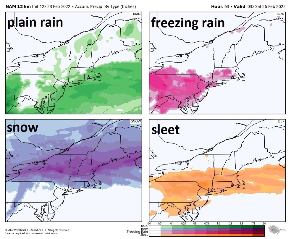
A wide variety of precipitation types expected in the Mid-Atlantic region as depicted here by the 12Z NAM in terms of accumulation accounts for each. Map courtesy NOAA, Weather Bell Analytics
On Thursday evening, the onset of the more intense precipitation may be in the form of snow across southeastern PA and interior southern/central New Jersey with small accumulations even possible (trace to an inch or two). Farther to the north, the initial burst of snow may last longer and be a bit more intense potentially yielding a few inches of accumulations from east-central PA to NW New Jersey to the NYC metro region. To the south of the Mason-Dixon Line on Thursday evening, precipitation is most likely to be in the form of rain and it can freeze on untreated surfaces for awhile in some of the northern and western suburbs of Washington, DC. The precipitation is likely to become rather spotty and relatively light later tomorrow night in and around the DC metro region.

An ice buildup is quite likely tomorrow night from northern Maryland to southern and central Pennsylvania as depicted here by the 12Z GFS model. Map courtesy NOAA, Pivotal Weather
Later tomorrow night, any snow across southeastern PA and interior southern/central NJ is likely to change to a period of sleet and then to a period of freezing rain. A significant ice buildup is certainly on the table later tomorrow night in much of southern and central Pennsylvania including in all of the N/W suburbs of Philly. Farther north, the snow may continue for a longer time period, but even there, the precipitation should change to sleet in the overnight hours and then ultimately to freezing rain.
As far as the Friday AM commute is concerned in the I-95 corridor, it looks like it can be an icy mess from the N/W suburbs of Philly to the NYC metro area. In the DC metro region, temperatures are likely to be slightly above freezing by early Friday morning limiting the chances there for any kind of widespread negative impact on the AM commute. One final note, any time we talk of a potential significant buildup of ice on untreated surfaces such as is the case for tomorrow night across much of Pennsylvania and perhaps northern Maryland, we have to, unfortunately, mention the possibility of power outages…a threat we’ll continue to monitor.
Meteorologist Paul Dorian
Arcfield
arcfieldweather.com
Follow us on Facebook, Twitter, YouTube
Video discussion: