
2:15 PM | **Rain today/tonight and some of it can be heavy…some icing later Friday in suburban locations to the north/west of I-95 as Arctic air filters in...appears it will be limited in nature**
Paul Dorian

The hour-by-hour advance of the Arctic air between 7AM Friday, February 4th and 7AM Saturday, February 5th as depicted by the 12Z NAM (3-km version). Maps courtesy NOAA, tropicaltidbits.com
Overview
Quite a muddy mess in the Mid-Atlantic region today with occasional rain, snowmelt, and some patchy fog as well - all out ahead of a slow-moving Arctic cold frontal system that has wreaked havoc on much of the heartland during the past couple of days with snow, ice and rain. That cold front will inch its way across the DC-to-Philly-to-NYC corridor tomorrow morning and an Arctic air mass will filter into the region from the northwest-to-southeast. After a very mild start early in the day along the immediate I-95 corridor, temperatures will fall throughout the remainder of Friday following the passage of the Arctic front. As a result, any plain rain that is falling early tomorrow can begin to freeze on some untreated surfaces by mid-day or early afternoon across suburban locations to the north and west. The rain can also mix with or change to sleet and/or snow for a brief time later in the day on Friday. It does appear that the icing potential in this case will be rather limited in nature around here as drier air will tend to inhibit any appreciable amounts of precipitation while we are on the cold side of the front. Temperatures are likely to continue to drop tomorrow night which can lead to a quick freeze-up of any standing water that still remains.

The first decent rainfall in awhile for the Mid-Atlantic region with most areas along and northwest of I-95 to receive at least half an inch by early tomorrow. Map courtesy NOAA, tropicaltidbits.com
Details
The slow-moving Arctic front that we have been tracking all week continues to be the focus area today of snow, ice and rain. In some areas, the snow has been significant during the past 24 hours or so and in other areas, the ice has been serious in nature with widespread power outages now being reported from eastern Texas-to-eastern Arkansas-to-western Tennessee-to-northern Kentucky-to-southwestern Ohio. On the front (and mild) side of this Arctic front, rain has been falling rather heavily at times and there has been some thunderstorm activity as well. In fact, some parts of the Southeast US is under the threat of severe weather including tornadoes from this very active frontal system.
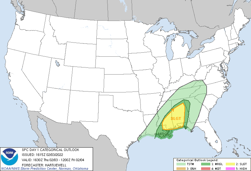
There is the threat of severe weather later today into tonight across the southeastern states - currently on the warm side of the slow-moving Arctic front. Map courtesy NOAA/SPC
Rain pushed into the Mid-Atlantic region in the overnight hours and it will continue off and on right through tonight. In fact, some of the rain can fall moderate-to-heavy at times and the combination of the rain and snow melt in some areas is causing quite a muddy mess around here. By early tomorrow, the slow-moving Arctic front will inch its way across the I-95 corridor and temperatures will begin to drop here after a very mild start as the Arctic air mass filters in from the northwest-to-the-southeast. As a result, any (plain) rain that is falling on Friday morning can begin to freeze on untreated surfaces (e.g., trees, grass) by mid-day or early afternoon across some of the suburban locations to the north and west of the big cities. Later in the day, the (freezing) rain can mix with or change to sleet and/or snow for a brief time in some locations.

12Z GFS surface forecast map for mid-day Friday with some icing (pink, purple) to the northwest of I-95. Map courtesy NOAA, tropicaltidbits.com
The threat for any significant icing looks like it will be confined to those areas well to the north and west of the immediate I-95 corridor region, but certainly be on the lookout around here for some icy spots later tomorrow as temperatures drop to or below the freezing mark. One of the main reasons for the likely limited impact from icing around here in the immediate I-95 corridor region is the idea that drier air will tend to cutoff the precipitation not long after temperatures drop to the freezing mark or below. On Friday night, temperatures are likely to continue to drop so any standing water that may still exist can quickly freeze-up – something to monitor after sunset. Cold high pressure will take control this weekend and temperatures early Saturday morning are likely to be in the teens in many of the suburbs along the DC-to-Philly-to-NYC corridor.
Meteorologist Paul Dorian
Arcfield
arcfieldweather.com
Follow us on Facebook, Twitter, YouTube
Video discussion: