
1:15 PM | ****”High wind” event from later Saturday into Saturday night with an Arctic blast…significant interior snows and accumulating snow likely to the I-95 corridor****
Paul Dorian

Overview
Many ingredients are going to come together for an extreme wind event in the Mid-Atlantic region and Northeast US from later Saturday into Saturday night. In addition to the expected high winds, snowfall on the back side of an Arctic cold front will be significant across interior sections of the northeastern quadrant of the nation. There can even be some accumulating snow all the way down into the DC-to-Philly-to-NYC corridor and perhaps to coastal sections of the eastern US. Wind gusts of 50-60 mph are possible later Saturday and Saturday night and that kind of intensity raises the possibility of downed tree limbs and power outages in the Mid-Atlantic/Northeast US. The weather will calm down some by later in the day on Sunday, but it’ll remain much colder-than-normal for this time of year with highs generally confined to the 30’s in the I-95 corridor.

Details
After a couple of fairly tranquil days around here both today and tomorrow, the weather turns much more active as we head into the upcoming weekend. A strong Arctic cold front will charge eastward over the next couple of days and its boundary zone will become the focus area on Saturday for the formation of surface low pressure. Many ingredients will come together on Saturday that will contribute to a rapid intensification of this surface low pressure system as it moves along the Arctic frontal (temperature) boundary zone from the southwest to the northeast. These ingredients which include strong jet streaks at multiple layers of the atmosphere and a phasing together of vorticity maxima in the southern and northern branches of the jet stream will also act as a catalyst for the very high wind gusts that are expected to develop in the northeastern states following the frontal passage.

Ahead of the Arctic cold front, there will be some rain from late Friday night into early Saturday morning along the I-95 corridor and temperatures will likely reach their highs for the day at this time. Following the passage of the Arctic front later Saturday, temperatures should drop sharply and the rain will change to snow and there certainly can be sleet involved during the transition. The changeover to snow will first take place across interior sections of the Mid-Atlantic/NE US and then works its way from west-to-east likely all the way into the I-95 corridor.

12Z Euro has accumulating snow on Saturday all the way down to the coastal sections of the eastern US. map courtesy ECMWF, Pivotal Weather
Snow accumulations are likely to be significant across interior sections from West Virginia to northern New England with 6-12 inches possible in many of these higher elevation locations. In fact, if you like to ski in northern New England, this storm will make you happy as places like Vermont and New Hampshire should get hit hard with accumulating snow this weekend. Accumulating snow is even possible all the way into the DC-to-Philly-to-NYC corridor later Saturday following the passage of the Arctic front and sleet can be in the mix as well. One other concern for Saturday is the possibility for a quick “freeze-up” on the roads after the “pre-frontal” rainfall and the subsequent sharp drop in temperatures.

Perhaps even more of a concern than the snow and possible ice are the winds which will intensify dramatically by later Saturday and Saturday night as the surface low pressure system intensifies rapidly. A very tight pressure gradient will develop by late Saturday between the departing strong (and still intensifying) low pressure system over northern New England and a strong high pressure system that will build over the southern states. The result of this tight pressure gradient will be wind gusts in the 50-60 mph range from later Saturday into Saturday night and this kind of intensity can certainly raise the possibility of some downed tree limbs and power outages.
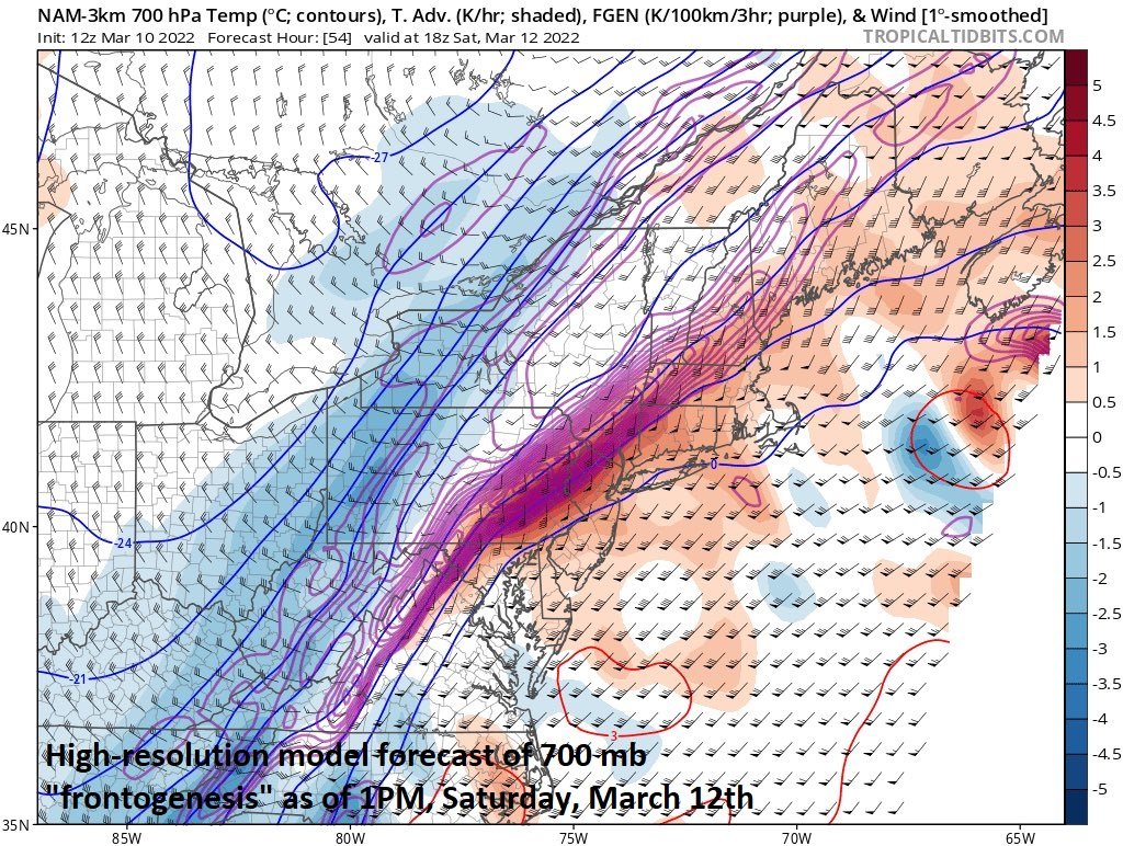
Impressive mid-level “frontogenesis” on Saturday is depicted here by the high-resolution (3-km) version of the NAM model which can result in heavier “mesoscale” banding of snow on the back side of the Arctic frontal system. Map courtesy NOAA, tropicaltidbits.com
The atmosphere calms down some by later Sunday, but temperatures will remain well below-normal for this time of year with afternoon highs generally confined to the 30’s in the DC-to-Philly-to-NYC corridor. Looking ahead, calmer and milder conditions are expected in the eastern US during the first half of next week, but it may be a tough haul to get to that point.
Meteorologist Paul Dorian
Arcfield
arcfieldweather.com
Follow us on Facebook, Twitter, YouTube
Video discussion: