2:15 PM | ***A cold blast arrives this weekend in the Mid-Atlantic/Northeast US…temperatures could drop to freezing late Sunday night and again late Monday night***
Paul Dorian

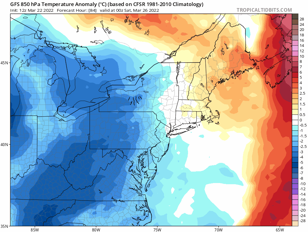
12Z GFS forecast maps of 850 mb temperature anomalies from Friday, March 25th at 8PM to Tuesday, March 29th at 8PM with below-normal temperatures dominating the scene. Maps courtesy NOAA, tropicaltidbits.com
Overview
Spring has sprung, but that is not quite the end of the cold air outbreaks for the Mid-Atlantic region and the Northeast US. In addition, snow cannot be ruled out for interior sections this weekend with the influx of cold air and perhaps there will be another snow threat early-to-mid next week.

“Lake-effect” type snows could kick in this weekend with an influx of cold air resulting in snow bands just downstream from the Great Lakes. Map courtesy NOAA, tropicaltidbits.com
Details
Rain is coming to the Mid-Atlantic region and Northeast US at mid-week and it looks like the rain threat can continue into early Friday morning. One low pressure system will push to the northeast over the next 24 hours or so from the Central Plains to the Great Lakes and a second low will form off the east coast later in the week. As a result, rain will spread into this region late tomorrow/early tomorrow night and the threat of rain with possible thunderstorms will last through Thursday night in the Mid-Atlantic and into Friday morning across the Northeast US.

Deep upper-level low could rotate into New England early next week and - with plenty of cold air in place - it raises the chance for snow in parts of the northeastern quadrant of the nation. Map courtesy NOAA, tropicaltidbits.com
By the early part of the upcoming weekend, colder air will begin to drop south and east from the Great Lakes and winds will begin to pick up in intensity from the northwest. The main thrust of the incoming cold air will arrive for the second half of the weekend and the early part of next week with temperatures likely remaining well below-normal into the day on Tuesday. Temperatures could drop to freezing or below in many suburban locations along the DC-to-Boston corridor on late Sunday night and again late Monday night. In fact, temperatures could drop to within a few degrees of the freezing mark in some suburban spots as early as late Saturday night/early Sunday morning. Any sensitive outdoor plants may have to be tended to on any of these three nights later this weekend and into the early part of next week.
In terms of snow, there certainly can be some “lake-effect” type snow bands that develop on Saturday and they can continue into Sunday primarily impacting those typical higher elevation locations of the Mid-Atlantic/Northeast US which lie just downstream from the Great Lakes. Another strong wave in the upper atmosphere could rotate into the Northeast US early-to-mid next week and with cold air in place, it may result in some snow for parts of the region…something to assess in coming days.
Meteorologist Paul Dorian
Arcfield
arcfieldweather.com
Follow us on Facebook, Twitter, YouTube
Morning video discussion which focuses on today’s severe weather threat: