
1:15 PM | ***Cold blast arrives this weekend in the Mid-Atlantic/Northeast US and sticks around for awhile…far below-normal temperatures on Monday***
Paul Dorian
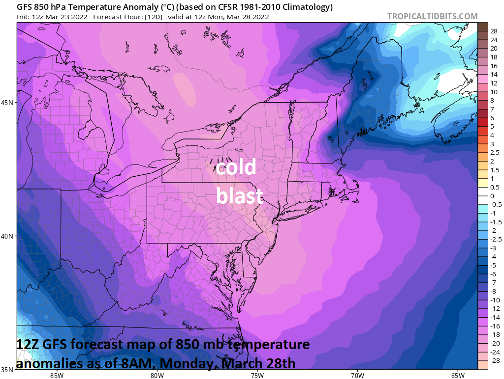
The core of the upcoming cold air blast will be in place on Monday in the Mid-Atlantic/NE US with temperatures as much as 25 degrees below-normal for late March. Map courtesy NOAA, tropicaltidbits.com
Overview
The calendar says its spring, but as has been the case in many recent years, winter will not go away without a fight. A cold blast will arrive in the Mid-Atlantic/Northeast US on Saturday and by the time we get to the early part of next week, temperatures will be far below-normal for the latter part of March. In fact, this cold air outbreak will likely bring temperatures to below the freezing mark in most areas in the overnight hours early next week making outdoor sensitive plants quite vulnerable to damage. In addition to the cold, the chance for snow (or other forms of frozen precipitation) will return this weekend to the Mid-Atlantic/Northeast US and there may be other threats coming this way later next week.

This forecast loop of 850 mb temperatures anomalies extends from early Saturday to early Tuesday with well below-normal readings throughout much of that time period. Maps courtesy NOAA, tropicaltidbits.com
Rain in the near-term
Rain has arrived in the DC metro region at mid-day and is advancing pretty rapidly to the northeast and likely to reach Philly by mid-afternoon and NYC by day’s end. The threat of rain will continue tonight, tomorrow and even tomorrow night and there can be some thunderstorm activity mixed in as well with downpours on the table during the next 24-36 hours. One low pressure system will push northeastward over the next 24 hours from the Upper Midwest to southern Canada and a secondary low will form later tomorrow near the northern Mid-Atlantic coastline. The combination of the two lows will result in a rather extended period with the threat of rain from this afternoon into early Friday although much of the time will be rain-free.

A cold front will push from west-to-east on Saturday and usher in colder air for the Mid-Atlantic/NE US and a secondary cold front will arrive by Sunday. The coldest air “relative to normal” will move overhead on Monday with temperatures as much as 25 degrees below-normal. Map courtesy NOAA, tropicaltidbits.com
Cold blast arrives this weekend
After a relatively mild day on Friday, cold air will begin an eastward push on Saturday reaching the Ohio Valley in the morning and then the Mid-Atlantic/Northeast US later in the day. The initial shot of colder air on Saturday will be supported by a vigorous wave of energy aloft likely resulting in rain showers across the I-95 corridor from mid-day into the evening and “lake-effect” snow showers across interior higher-elevation sections of the northeastern states. In fact, as colder air moves in aloft on Saturday, it wouldn’t be too surprising to see some sleet or graupel (i.e., snow pellets) mix in with the rain close to the I-95 corridor.

“Lake-effect” snow will form on Saturday just downstream of the Great Lakes as colder air arrives; primarily, in those interior, higher elevation locations (e.g., West Virginia, western PA, upstate NY). Rain showers are likely at mid-day and during the afternoon in the immediate I-95 corridor and it wouldn’t be too surprising to see sleet or graupel (i.e., snow pellets) mix in at times. Map courtesy NOAA, tropicaltidbits.com
By Saturday night and Sunday, northwest winds will become quite stiff and even colder air will move into the region following the passage of a secondary cold front. Temperatures are very likely to drop to below-freezing on Sunday night and again on Monday night in most of the Mid-Atlantic/NE US - including in the urban areas along Route I-95. In fact, temperatures may come pretty close to the freezing mark as early as early Sunday morning in some suburban locations. Sensitive outdoor plants may have to be tended to on any of these three nights later this weekend and early next week.
In addition to the “lake-effect” type snows this weekend with the initial influx of colder air, a threat of frozen precipitation is on the table by the middle of next week. By next Tuesday, a northwest-to-southeast oriented frontal boundary zone will set up extending from the Northern Plains into the Mid-Atlantic region. It is quite possible that one or more waves of low pressure develop along that frontal boundary zone and - with plenty of cold air in place - this would raise the possibility of snow or other forms of frozen precipitation by the middle of next week…perhaps a long shot, but something to monitor in coming days.
Stay tuned and get ready for the return of below-freezing temperatures as winter won’t go away without a fight.
Meteorologist Paul Dorian
Arcfield
arcfieldweather.com
Follow us on Facebook, Twitter, YouTube
Video discussion: