
12:30 PM | ***Severe thunderstorms on the table from later today into later tonight…risk includes damaging wind gusts, torrential rain and isolated tornadoes***
Paul Dorian

Jet streaks at multiple levels of the atmosphere will play a role in the severe weather threat later today and tonight across the eastern US. This forecast map depicts strong winds in the lower levels of the atmosphere as of 6PM, Thursday. Map courtesy NOAA, tropicaltidbits.com
Overview
There was a severe weather outbreak yesterday across the Deep South and Tennessee Valley and many of the same catalysts will move in the eastern states by later today. At the surface, strong low pressure will move from the Great Lakes into western Quebec and it’ll help to lift a warm front across our area paving the way for a surge in temperatures into the 70’s in many spots. This surge in temperatures will be aided by intervals of sunshine that should develop later today just ahead of a strong cold frontal system. This front will move from west-to-east and it’ll approach the I-95 corridor region by the end of the day.
In the upper atmosphere, a complex weather pattern will feature multiple jet streaks and numerous shortwaves - all leading to increasing upward motion later today/tonight centered right over the Mid-Atlantic region. Showers will be of the isolated-to-scattered variety for the bulk of the day; however, more numerous showers will overspread the region by the early evening hours. In addition, the threat for severe thunderstorm activity will increase as we go through the evening hours with damaging wind gusts and isolated tornadoes on the table.

Jet streaks at multiple levels of the atmosphere will play a role in the severe weather threat later today and tonight across the eastern US. This forecast map depicts strong winds at 250 mb (~35,000 feet) as of 6PM, Thursday. Map courtesy NOAA, tropicaltidbits.com
Details
Surfaces fronts, multiple jet streaks and numerous shortwaves rotating through a large upper-level trough will come together later today and tonight to bring a severe weather threat to the Mid-Atlantic putting damaging wind gusts of 60+ mph, torrential rain, hail, and even isolated tornadoes on the table. One jet streak will develop high up in the atmosphere (250 millibar level/~35,000 feet) with winds of 150 mph and its “left, exit” region will move overhead later today promoting strong upward motion at the same time a strong surface cold front slides in from the west. In addition to the upper-level jet streak, there will be quite impressive wind shear (change of wind speed and direction with height) developing in the lower levels of the atmosphere which would not only add to the instability, but it could potentially lead to mid-level rotation which can be a precursor to the formation of isolated tornadoes. The greatest low-level vertical wind shear will probably set up away from coastal sections likely centering over northern Maryland and eastern Pennsylvania. Yet another factor leading to a destabilization of the atmosphere will be the daytime heating that is expected to intensify during the mid-to-late afternoon; especially, considering the fact that skies are clearing at mid-day across interior sections of the Mid-Atlantic region. The timetable for the strong-to-severe thunderstorm activity in the Mid-Atlantic region will be from late-afternoon through late evening with the likelihood that the main squall line will not arrive into the immediate DC-to-Philly-to-NYC corridor until after 8pm or so.
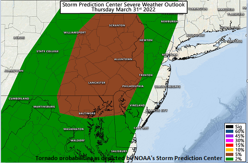
NOAA’s SPC has put a 5% risk (brown shading) of tornadoes for later today and tonight in eastern PA and northern MD. Map courtesy NOAA
After the passage of the cold front, colder air will push into the Mid-Atlantic/NE US on Friday, but this will not end of the threat of rainfall. A lagging upper-level trough will pivot across the region tomorrow resulting in lots of clouds, breezy conditions and scattered showers. In the western and higher elevation sections of the Mid-Atlantic/NE US, it may be just cold enough for “lake-effect” snow showers to take place, but it shouldn’t be as active as earlier this week. The upper-level trough finally exists to the east on Friday night and high pressure will build in for the start of the upcoming weekend. Another upper-level trough heads this way for Sunday bringing with it more clouds and the chance for additional rain showers.
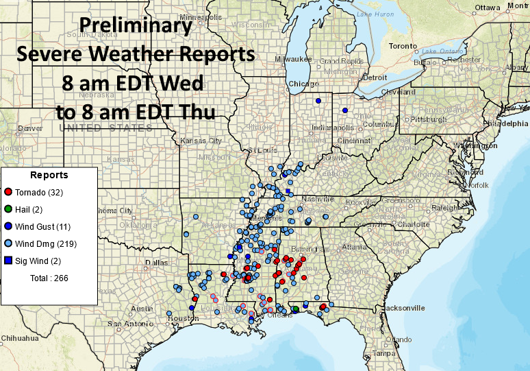
A severe weather outbreak on Wednesday resulted in numerous reports of damaging wind gusts across the Deep South and Tennessee Valley as well as several tornadoes. Map courtesy NOAA
Meteorologist Paul Dorian
Arcfield
arcfieldweather.com
Follow us on Facebook, Twitter, YouTube
Video discussion: