12:30 PM | ***March madness next 48 hours…begins with record-warmth, high winds, downpours, strong-to-severe thunderstorms…possible accumulating snow on Wednesday***
Paul Dorian

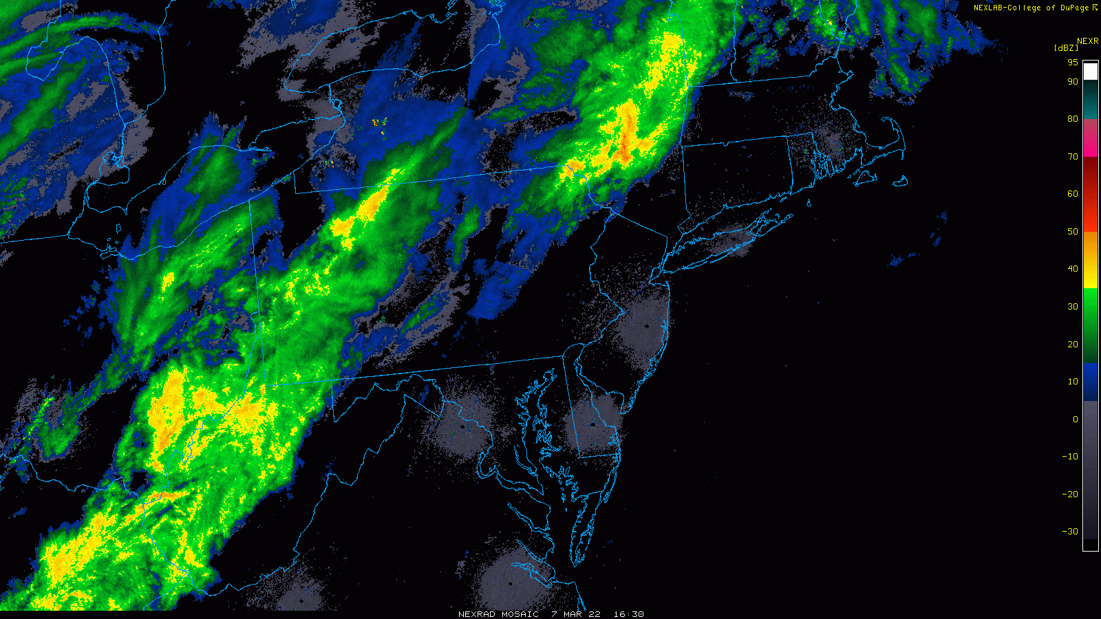
Showers will become numerous in the I-95 corridor later today and continue into the evening and there can be some embedded strong-to-severe thunderstorms. Maps courtesy NOAA, College of DuPage
Overview
Talk about some wild weather…
The Mid-Atlantic region will experience some March madness of its own over the next 48 hours or so with record-warmth today along with high winds and late day/evening heavy showers and scattered strong-to-severe thunderstorms and then much colder conditions by mid-week with the chance for accumulating snow. Today’s weather is courtesy of an approaching strong cold frontal system that will pass through the area tonight and set the stage for much colder weather by mid-week. Low pressure will push towards the southern Mid-Atlantic coastline by early Wednesday and it can be cold enough for some accumulating snow in parts of the Mid-Atlantic region. Another impressive cold blast will reach the eastern states early in the upcoming weekend.

A strong cold front arrives in the I-95 corridor this evening and there can be some strong-to-severe thunderstorm activity. Map courtesy NOAA/SPC
Details
Temperatures today are moving through the 70’s in many parts of the DC-to-Philly-to-NYC corridor and there are going to be some record highs set - all ahead of an approaching strong cold frontal system. (Some example record highs for today in jeopardy include 74 degrees at Philly Airport, 76 degrees at Dulles and BWI Airports, and 77 at Reagan National Airport (DCA)). Winds have increased in intensity and can gust to 50+ mph this afternoon from a southwesterly direction and then can gust to 50 mph from a northwesterly direction later tonight following the passage of the strong cold front. Showers will become numerous later in the day and then continue through much of the evening and some of the rain can be heavy at times. In addition, there is the chance for some strong-to-severe thunderstorm activity as the front approaches early tonight which can result in enhanced wind gusts and downpours.
On Tuesday, winds will remain stiff from a northwesterly direction and it’ll be noticeably colder compared to today’s potential record-breaking warmth. High pressure will move overhead during the day on Tuesday as it pushes eastward from the Upper Midwest. Clouds will thicken up tomorrow night as low pressure begins a push from the Tennessee Valley towards the southern Mid-Atlantic coastline.

Snow is indeed on the table for early Wednesday in parts of the Mid-Atlantic region and accumulations cannot be ruled out. Map courtesy NOAA, tropicaltidbits.com
By early Wednesday, precipitation will break out in much of the Mid-Atlantic region and it can be cold enough for some snow – even in the immediate I-95 corridor from DC-to-Philly-to-NYC. As is often the case this time of year and in most borderline temperature situations, the greater chances for snow accumulations will be to the north and west of the big cities; especially, in any higher elevation location. Also, any accumulation of snow on Wednesday would be much more likely on grassy surfaces as compared with asphalt (i.e., road) surfaces. Low pressure will likely move from southwest-to-northeast across southeastern Virginia and then to a position out over the open waters of the western Atlantic by mid-day on Wednesday. This track puts the DC-to-Philly-to-NYC corridor in the cold sector of the storm (i.e., on the northwest side) which puts accumulating snow on the table.

A very impressive cold blast will arrives in the eastern states early this weekend and below-normal temperatures will rule the bulk of Saturday and Sunday. Map courtesy NOAA, tropicaltidbits.com
After modification in temperatures later this week, another very impressive cold blast is destined to arrive in the eastern states this weekend. The next strong front may arrive in the I-95 corridor on Saturday morning with rain ahead of it and the chance for some snow following its passage; especially, across interior sections of the Mid-Atlantic/Northeast US. Much colder-than-normal air for this time of year will then encompass much of the eastern US for the Saturday night/ Sunday time period.
Meteorologist Paul Dorian
Arcfield
arcfieldweather.com
Follow us on Facebook, Twitter, YouTube
Video discussion: