
12:45 PM | *Soaking rain event for the Mid-Atlantic region from Friday into Saturday…becomes quite cool and windy as well*
Paul Dorian

An anomalously strong high pressure ridge will set up in the upper part of the atmosphere over southeastern Canada by the early and middle parts of next week. This system will help to steer stalled-out low pressure from the western Atlantic back towards the US east coast later next week. Map courtesy NOAA, tropicaltidbits.com
Overview
A soaking rain event is coming to the Mid-Atlantic region for Friday and Saturday and it’ll become quite cool and windy as well. Intensifying low pressure will cross over the Ohio Valley on Friday and then as it arrives the eastern US, it will begin to become influenced by building high pressure over southeastern Canada. As such, the low pressure will slow down in its advance to the east and ultimately will stall-out over the western Atlantic. The “blocking” type pattern that sets up in the upper atmosphere could prolong the chilly, damp weather into Sunday, Mother’s Day; especially, along coastal sections of the Mid-Atlantic. Later next week, the strong block will likely result in a retrogression of the stalled-out low pressure system and it likely moves from east-to-west and back to the east coast perhaps classified as a “sub-tropical” system.
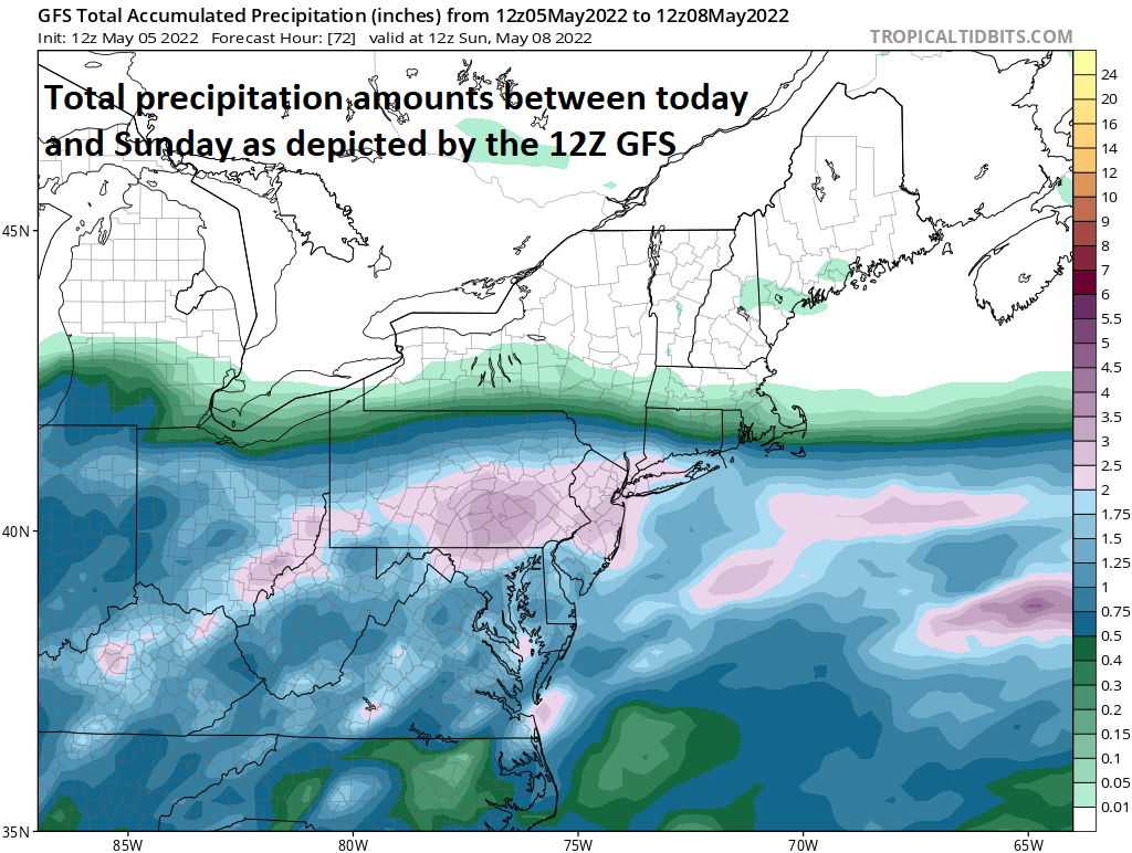
Rainfall amounts of 2-3 inches are on the table for this upcoming storm system in the Mid-Atlantic. Map courtesy NOAA, tropicaltidbits.com
Details
Low pressure will develop later today over the Lower Mississippi Valley and it will intensify on Friday as it moves over the Ohio Valley. Rain is likely to develop early Friday in the Mid-Atlantic region and then continue off and on and heavy at times right through tomorrow night and well into the day on Saturday. In fact, with a “blocking” pattern setting up in the atmosphere, this same low pressure system is likely to impact portions of the Mid-Atlantic into Sunday as well; especially, along coastal sections of Virginia, the Delmarva Peninsula and New Jersey. Rainfall amounts of 2-3 inches are on the table for many spots in the Mid-Atlantic region during this upcoming rain event. In addition to the rain, it’ll turn quite cool during the storm and (onshore) winds will intensify by Friday night and Saturday. The low pressure system will push off the east coast later in the weekend and grind to a halt out over the western Atlantic Ocean.

Low pressure will slow down as it reaches the eastern US and can cause rainfall on Friday and Saturday in the Mid-Atlantic region and perhaps even into early Sunday; especially, along coastal sections. Maps courtesy NOAA, College of DuPage
Meanwhile, a very strong high pressure ridge will develop in the upper part of the atmosphere over the southeastern part of Canada. This anomalously strong ridge of high pressure will ultimately play a role in pushing the stalled-out low pressure system back towards the east coast later next week. This low may end up being classified by NOAA as a “sub-tropical” system or perhaps even a “tropical” system by the time it backs westward later next week to the eastern seaboard.
Meteorologist Paul Dorian
Arcfield
arcfieldweather.com
Follow us on Facebook, Twitter, YouTube
Video discussion: