7:15 AM | *50 years ago this week one of the worst natural disasters Pennsylvania ever faced...Tropical Storm Agnes...DC, Virginia hit hard as well*
Paul Dorian

Track of Agnes from June 14th – June 23rd, 1972 (white circles indicate category 1 hurricane status); courtesy Wikipedia
Overview
The official Atlantic Basin tropical season was barely underway in June of 1972 when a polar front interacted with an upper-level trough of low pressure over the Yucatan Peninsula. Within a few days, a tropical depression formed and the system moved slowly eastward and emerged in the western Caribbean Sea by the middle of the month. The depression began to intensify over the warm waters of the Caribbean Sea and soon became Tropical Storm Agnes – the first named storm of the 1972 tropical season. Ultimately, Agnes would reach hurricane status, grow to a diameter of about 1000 miles, and become the costliest hurricane at the time to hit the US and the Commonwealth of Pennsylvania was the prime focus of its wrath.

Satellite image of Agnes on the first day it reached hurricane status just off the western tip of Cuba. Courtesy NOAA
General Discussion
Tropical Storm Agnes intensified over the Caribbean Sea in the middle of June 1972 and began curving northward passing just to the west of Cuba on June 17th. By the next day, Agnes reached hurricane status and then made landfall near Panama City, Florida on June 19th as a category 1 (weak) hurricane. In typical fashion, the tropical system weakened once it moved over land and dropped back to “depression” status as it pushed northeastward into Georgia.
Close-up of Agnes approaching Florida as a category 1 hurricane in June 1972; courtesy NOAA
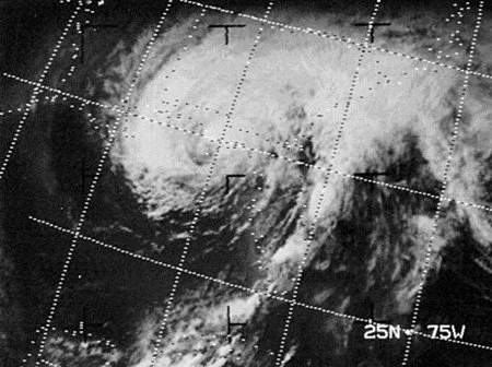
However, in this particular case, the tropical system then began to regain strength as it pushed through South Carolina and into eastern North Carolina. In fact, while over eastern North Carolina, Agnes regained tropical storm status as it was about to head out over the waters of the western Atlantic Ocean before re-curving northwestward and making landfall near New York City as a strong tropical storm. After this, Agnes ran into an atmospheric road block (i.e., upper-level blocking pattern) and this forced it to slow down and loop around into northern Pennsylvania where it eventually gradually dissipated. The slow movement of Agnes allowed for some incredible rainfall amounts to pile up in the Mid-Atlantic region; especially, in the Commonwealth of Pennsylvania.

Satellite image of the remnants of Agnes once over the Northeast US; courtesy NOAA
Pennsylvania’s worst nightmare
The weeks before Agnes approached Pennsylvania in June 1972 were quite wet with numerous heavy rain events. As a result, a disaster was almost unavoidable with the onset of slow-moving Agnes as grounds were already saturated throughout much of the state. As Agnes slowed down to a grinding halt right over northern Pennsylvania, the rainfall amounts piled up across the state and there was intense flooding – more so than in any other state. In many cases, the rivers rose to levels not ever seen before. The highest rainfall amount of 19 inches was measured over western Schuylkill County and much of the state ended up with at least 7 inches of rain making Agnes the wettest tropical cyclone ever for the state of Pennsylvania (the city of Philadelphia got off easy with only a few inches).
On June 22, the murky waters of the Susquehanna River reached eight feet above normal. Fourteen hundred National Guardsmen were ordered to the area where they worked to secure low-lying areas by erecting walls of shale, sandbags, and rock. By Friday, June 23, the river swelled to 38.5 feet; the dike had long since buckled and left surrounding towns truly vulnerable. On June 23, 1972, Harrisburg’s Patriot-News was canceled for the first time since it began in 1852. By Saturday evening on June 24th, the water levels had reached their peak and Agnes pummeled Wilkes-Barre and the Wyoming Valley with 14 trillion gallons of water; submerging homes and destroying communities.

Floodwaters from Agnes surround the Governor’s mansion in Harrisburg, PA
Elsewhere, the Brandywine Creek crested at 16.5 feet in Chadds Ford (Delaware County) sending flooding waters into that city. In Reading, the Schuylkill River reached a record flood level of 31.5 feet and hundreds of people were evacuated. In the end, more than 100,000 people were forced to leave their homes across the state due to flooding including many in the capital city of Harrisburg where some buildings were under 13 feet of water. Gov. Milton Shapp and first lady Muriel Shapp were rescued by boat from the flooded governor's mansion. By the time the storm finally ended, there were 128 deaths directly attributed to Agnes and 50 of those occurred in Pennsylvania – more than twice that of any other state – and there were $2.3 billion in losses across the Keystone State.

Rainfall amounts from Agnes reached a peak in Pennsylvania with 19 inches recorded in western Schuylkill County
Impact on the DC metro region
Rainfall amounts were staggering across Pennsylvania and also in much of the DC metro region. Chantilly, Virginia, for example, recorded 16 inches from Agnes and 13.65" officially fell at Dulles Airport. Wind gusts peaked at around 50 mph at Dulles and National Airports (8.16” inches of rainfall recorded at DCA). The most tragic aspect of this event in the Washington D.C. area was the loss of sixteen people who were swept to their deaths in the swirling floodwaters. Most of these drownings involved motorists that were trapped in automobiles (credit Washington Post's Capital Weather Gang).
Final thoughts
Hurricane Agnes finally exited Pennsylvania on June 25, 1972 with its sights set on western New York. By most accounts, the scope of the devastation puts Hurricane Agnes at the top of Pennsylvania’s worst natural disasters, even though it did not cause the most deaths. The two deadliest, both of which occurred on May 31, were the Johnstown Flood of 1889 (2200+ fatalities) and the Great Pennsylvania Tornado of 1985 (65 fatalities) [credit Washington Post/Capital Weather Gang].
Agnes left quite a legacy among those who suffered her wrath; consequently, the name was retired by NOAA and barred from future use. In fact, Hurricane Agnes was the first category 1 hurricane in the Atlantic Basin to have its name retired and is today one of only five such storms with that distinction.
Meteorologist Paul Dorian
Arcfield
arcfieldweather.com
Follow us on Facebook, Twitter, YouTube