1:00 PM | ***Showers/strong-to-severe storms likely later today/early tonight in the Mid-Atlantic…can result in localized flooding…worst stretch of heat/humidity so far for the mid and late week***
Paul Dorian

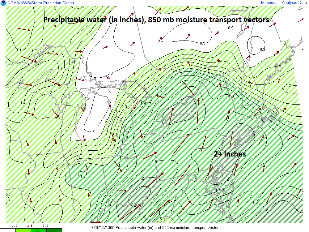
Very high moisture content exists today in the Mid-Atlantic region and this is an important contributing factor to the possibility of some heavy downpours later in the day and tonight. map courtesy NOAA/WPC
Overview
The combination of a very humid air mass and an impulse in the upper atmosphere drifting in this direction will likely result in numerous afternoon and evening showers and strong-to-severe thunderstorms in the Mid-Atlantic region. Given the high moisture levels and the ”lift” in the atmosphere that is expected later today, any PM shower or thunderstorm can dump a lot of rainfall in a short period of time with localized flooding a possibility. After a calmer day on Tuesday, the mid and late week will feature the worst stretch of heat and humidity so far this summer with afternoon highs in the low-to-mid 90’s along the DC-to-Philly-to-NYC corridor.

An impulse in the upper atmosphere will move overhead by early tonight and this system will produce upward motion and “lifting” in the DC-to-Philly-to-NYC corridor enhancing the chances for heavy showers and strong thunderstorms. Map courtesy NOAA, tropicaltidbits.com
Details
Several ingredients are coming together for the threat of some heavy rainfall later today and tonight across much of the Mid-Atlantic region and strong-to-severe thunderstorms. To begin, there is a steady southwesterly flow of air in the lower levels of the atmosphere and this is pumping in vast quantities of moisture. “Precipitable” water amounts are quite high today with readings in many spots of more than two inches and these levels are indicative of very high moisture content. Having high moisture content by itself is not a guarantee of heavy rainfall as there has to be a mechanism in the atmosphere to “squeeze” out this moisture and that may very well turn out to be an impulse aloft that is now dropping southeast from the Great Lakes region into the Mid-Atlantic. This “vorticity” max or “spin” in the atmosphere will slide overhead later today and tonight and should produce strong upward motion in the DC-to-Philly-to-NYC corridor.

A line of showers and embedded storms is depicted here by the 06Z NAM model run for the I-95 corridor f around 8 pm. Conditions are ripe for some heavy rainfall in the Mid-Atlantic with a combination of ingredients coming together. Map courtesy NOAA, tropicaltidbits.com
This “lifting” action in the atmosphere increases instability and, in turn, should enhance the chances for afternoon and evening showers and strong-to-severe thunderstorms – some of which can produce very heavy rainfall amounts in a short period of time. A batch of showers and storms already affected parts of the Mid-Atlantic region earlier today, but they have since pushed to the north, and numerous new showers and storms are headed this way from the eastern Ohio Valley/western Mid-Atlantic as upper-level support moves into the eastern states. One other note, heavy rainfall is a primary concern later today and tonight; however, also on the table are damaging wind gusts and even an isolated tornado or two associated with strong-to-severe thunderstorm activity. The threat of heavy showers and strong-to-severe thunderstorms will wind down later tonight and Tuesday promises to be a calmer day with some sunshine, quite warm conditions, and perhaps an isolated shower or thunderstorm.
Looking past tomorrow, it appears the worst stretch of heat and humidity will makes its way into the Mid-Atlantic/Northeast US for the mid and late week with afternoon highs likely in the low-to-mid 90’s from DC-to-Philly-to-NYC and not much respite at night with lows in urban areas in the upper 70’s. The heat in recent days has been confined to the central part of the nation, but it will finally make a push to the northeast for the mid and late week time periods. A weak frontal system could enhance chances for showers and thunderstorms on Thursday, but much of the second half of the week should be rain-free to go along with those expected hot and humid conditions. The weak front is likely to stall out in the region this weekend and that suggests there will be little to no relief in the hot and humid conditions which could very well persist right through Saturday and Sunday.
Meteorologist Paul Dorian
Arcfield
arcfieldweather.com
Follow us on Facebook, Twitter, YouTube
Video discussion: