12:10 PM | *”Hit or Miss” showers and thunderstorms in recent weeks frustrating those north of the PA/MD border…lawns turning brown in some areas…additional rain chances coming…but no guarantees*
Paul Dorian

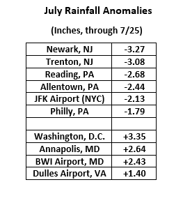
Quite a difference in rainfall anomalies for the month of July depending on which side of the PA/MD border one is located. Rainfall deficits are the rule to the north of the Mason-Dixon Line while surpluses exist to the south of there. Data courtesy NOAA
Overview
There have been many frontal passages in recent weeks across the Mid-Atlantic region that have produced showers and thunderstorms and, in some cases, severe weather. While these showers and thunderstorms have often been quite “numerous” to the south of the PA/MD border, they have usually been “isolated-to-scattered” across Pennsylvania, New Jersey and New York City. These “hit or miss” variety showers and thunderstorms are frustrating many residents to the north of the PA/MD border with lawns now beginning to turn brown in many areas. There will be additional chances of showers and thunderstorms in coming days, but still no guarantees; especially, to those north of the Mason-Dixon Line.
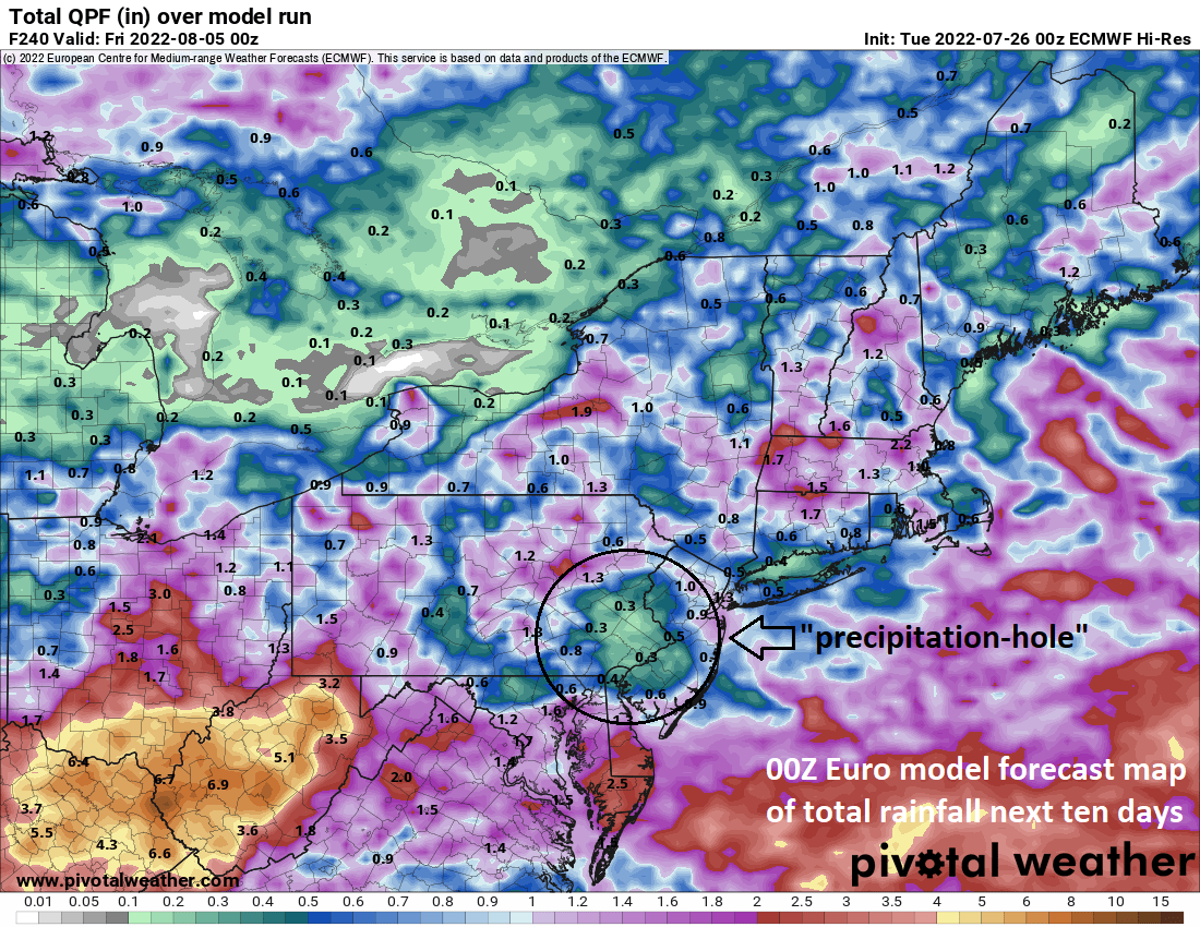
00Z Euro forecast map of rainfall amounts over the next 10 days continues a recent pattern of significantly higher amounts across Maryland, Virginia and DC when compared to locations to the north of the PA/MD border. In fact, a “precipitation-hole’ is clearly depicted here by this particular computer forecast model for the southeastern and east-central parts of Pennsylvania. Map courtesy ECMWF, Pivotal Weather
Details
It has been said that statistics don’t lie and if one takes a look at rainfall anomalies for the month of July, a noticeable difference is quite obvious for those areas north of the PA/MD border versus those to the south. From a scientific point of view, there is no reason that a geographical boundary like the Mason-Dixon Line should have any impact on precipitation patterns, but this isn’t the first such occasion. The winter before last featured much higher snowfall amounts to the north of the PA/MD border and far below-normal levels to the south of there. For the first 25 days of July, rainfall deficits are very common across southeastern and east-central Pennsylvania, New Jersey, and the NYC metro region while at the same time, rainfall surpluses dominate the picture across Maryland, Virginia and the DC metro area.
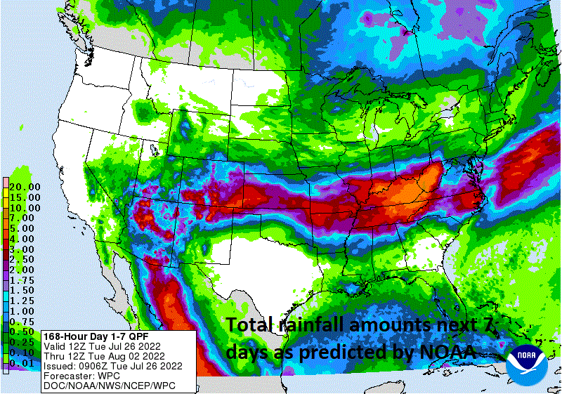
Total rainfall amounts over the next 7 days as depicted here by NOAA’s Weather Prediction Center (WPC) features higher amounts to the south of the PA/MD border. Map courtesy NOAA/WPC
Over the next few days there will be additional chances of rain in the Mid-Atlantic region, but there are signs the overall pattern of recent weeks may continue namely with better chances of significant amounts to the south of the PA/MD border. In fact, the 00Z Euro model forecast map of rainfall amounts over the next 10 days features a noticeable “precipitation hole” across southeastern and east-central Pennsylvania. There is actually some support for this particular model forecast by NOAA’s Weather Prediction Center (WPC) who depict noticeably higher rainfall amounts over the next 7 days to the south of the PA/MD border.
The first chance of rain in the Mid-Atlantic region comes later today and tonight as the frontal system that inched its way through last night returns to the north as a warm front. As has been the case recently, the best chance of the showers and thunderstorms from this active frontal boundary zone will be across Maryland, Virginia, and DC with lesser chances in Pennsylvania and New Jersey. A couple of upper-level disturbances will renew the chance of showers and thunderstorms on Wednesday and Thursday in the Mid-Atlantic region and then a frontal system arrives Friday with yet another opportunity for some rainfall. While these opportunities do present some hope to the moisture-starved residents of the northern Mid-Atlantic, there is no guarantee that any of these upcoming showers and thunderstorms will be much more than the “hit or miss” variety. However, to end on a more positive note, any shower or thunderstorm that does form over the next few days can certainly produce some significant rainfall amounts in a short period of time for a given location.
Meteorologist Paul Dorian
Arcfield
arcfieldweather.com
Follow us on Facebook, Twitter, YouTube
Video discussion: