10:30 AM | *The lid is about to come off…a change from very quiet to very active is on the table with respect to tropical activity in the Atlantic Basin*
Paul Dorian

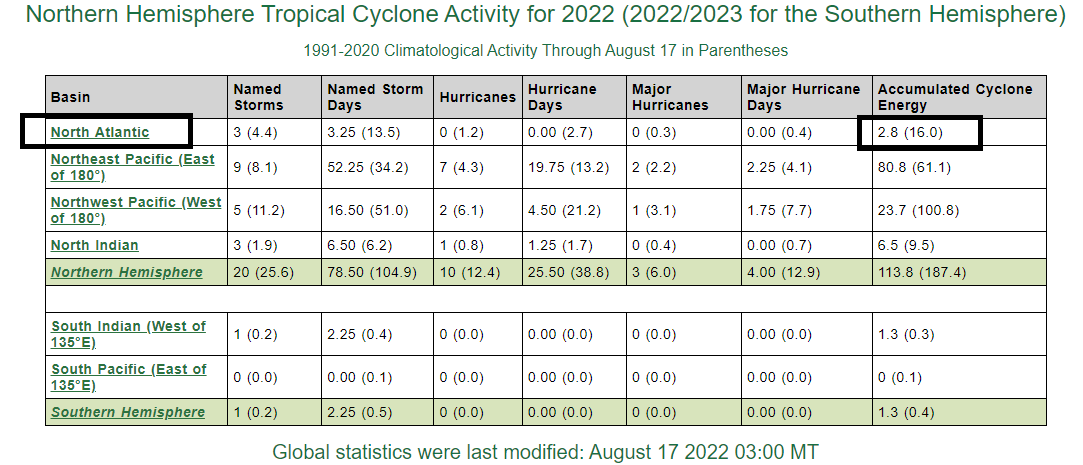
One of the best ways to measure overall tropical activity is with a metric known as the Accumulated Cyclone Energy or ACE. This is currently running at well below-normal levels in the Atlantic Basin, but big-time increases could be in the offing later this month and into September. Data courtesy Colorado State University, NOAA
Overview
We have now passed the mid-point of the month of August and, so far, tropical activity has been considerably below-normal in the Atlantic Basin. In fact, activity across the northern hemisphere as a whole has been below-normal as measured by a metric known as the “accumulated cyclone energy” or ACE. There are signs, however, that the lid is about to come off in the Atlantic Basin where a big-time increase in activity is increasingly likely over the next few weeks and beginning as early as this weekend over the Gulf of Mexico.

Two waves of interest exist now in the Atlantic Basin with one over the western Caribbean Sea and a second just off the west coast of Africa. Image courtesy University of Wisconsin/CIMSS, NOAA
Accumulated Cyclone Energy
One of the most accurate ways to monitor overall tropical activity is through the usage of a metric known as the accumulated cyclone energy or “ACE”. The ACE metric - which was originally created by Dr. William Gray and associates at Colorado State University and later tweaked by NOAA - not only factors in the intensity of a tropical cyclone, it also takes into account its longevity. A “major” hurricane, for example, that lasts for a long time will have a much bigger impact on the accumulated cyclone energy than a short-lived and weaker tropical system.
So far this tropical season – and there is a long way to go - activity has been well below-normal in the Atlantic Basin and across the northern hemisphere as a whole. Things are about to change, however, in the Atlantic Basin as environmental conditions are about to become much more favorable for tropical activity.
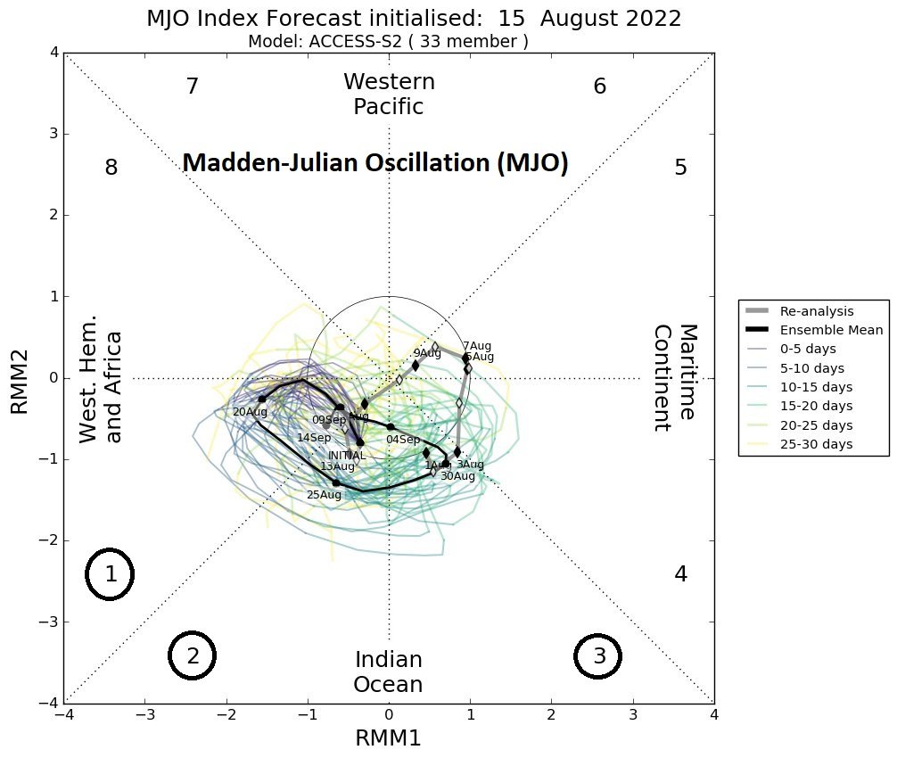
The Madden-Julian Oscillation (MJO) is forecasted to push into phases 1, 2 and 3 in coming weeks and this typically results in more tropical activity across the Atlantic Basin. Map courtesy Australian Meteorological Centre, Weather Bell Analytics (Joe Bastardi, Twitter)
Madden-Julian Oscillation (MJO)
One of the ways to assess favorability for tropical activity in the Atlantic Basin is through a metric known as the Madden-Julian Oscillation. The MJO can be characterized as an eastward moving “wave” or “pulse” of clouds and enhanced tropical rainfall near the equator that typically recurs every 30-to-60 days. The anomalous rainfall is often first evident over the Indian Ocean and remains apparent as it propagates eastward over the very warm waters of the western and central tropical Pacific. Over the cooler ocean waters of the eastern Pacific, the pattern of tropical rainfall generally becomes nondescript, but often reappears over the tropical Atlantic and Africa. One method meteorologists use to monitor the MJO is in an 8-phase diagram in which each phase generally coincides with locations along the equator around the globe. In addition to being informative about the location of the MJO, these phase diagrams provide some information to meteorologist as to the strength of the tropical disturbance as it traverses the tropics. Specifically, when the MJO index is within the center circle of the forecast plots, it is considered to be weak and when it is outside, it is stronger and usually moves in a counter-clockwise direction.
The different phases of the MJO correlate well with different temperature and precipitation patterns around the world depending on the given time of year. The current forecast by several computer forecast models, indicate that the MJO will swing into phases 1, 2 and 3 as we progress through the rest of August and into the month of September. Past observations show that these particular phases of the MJO during this time of year are quite supportive of increased tropical activity in the Atlantic Basin.

Higher heights (and pressure) than normal over SE Canada/NW Atlantic this time of year often results in tropical systems that can “undercut” the ridging potentially increasing their chances for an impact on the US mainland. Map courtesy NOAA, tropicaltidbits.com
Upper-air pattern
Another important factor to monitor this time of year with regard to the likelihood of tropical activity in the Atlantic Basin is the 500 millibar height pattern over North America. If higher heights (and pressure) develop over the southeastern part of Canada and the northwestern Atlantic Ocean this time of year, past observations tell us that chances tend to increase for tropical systems to impact the east coast of the US, Gulf of Mexico and/or Caribbean Sea. These potential tropical systems tend to “undercut” the high pressure ridging that can set up over SE Canada and the NW Atlantic. Indeed, forecast models suggest such anomalous ridging may form in this very region later this month and into the early part of September. This is a warning sign that tropical systems may indeed have the ability later this month to move from east-to-west and potentially towards the US mainland.
Stay tuned…the very quiet tropical season in the Atlantic Basin may soon become very active.
Meteorologist Paul Dorian
Arcfield
arcfieldweather.com
Follow us on Facebook, Twitter, YouTube
Video discussion: