10:15 AM | **Well up in the 90's on Thursday…heavy rainfall becomes a threat from Thursday evening right into the upcoming weekend**
Paul Dorian

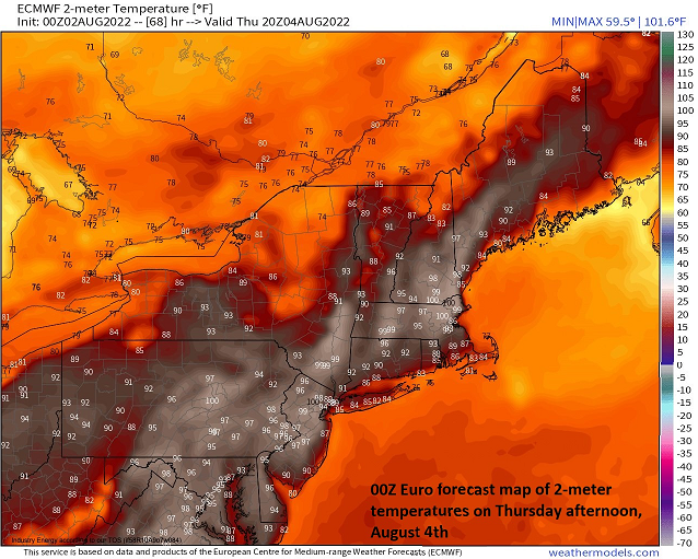
Temperatures on Thursday afternoon could climb into the 95-100 range along the DC-to-Philly-to-NYC corridor. Map courtesy “weathermodels.com”, ECMWF
Overview
The week started off with below-normal temperatures in much of the Mid-Atlantic region thanks to plenty of cloud cover and a light low-level easterly breeze. As is often the case this time of year, the break in the heat will be rather short-lived. High pressure pushes off the east coast at mid-week and the peak in this week’s heat and humidity in the Mid-Atlantic region may come on Thursday after persistent southwesterly flow develops on the backside of the high. After that, the potential exists for some heavy rainfall from Thursday night into the upcoming weekend as a frontal system stalls in the region with weak wind flow aloft and a very moist overall environment.

High heat and humidity will surge into the northeastern states on Thursday as southwesterly flow intensifies on the backside of high pressure which will shift to the western Atlantic. Map courtesy NOAA, tropicaltidbits.com
Peak of the heat and humidity may come on Thursday
The first day of the work week featured below-normal temperatures in much of the Mid-Atlantic region; especially, in eastern PA, New Jersey, and southeastern NY where stubborn clouds held on through the day and a low-level easterly flow of air developed. Temperatures today will be noticeably warmer with the return of sunshine and they’ll stay on the warm side at mid-week as high pressure heads towards the east coast.
By Thursday, with the high shifting to a position off the coast, broad southwesterly flow will funnel hot and humid air into the Mid-Atlantic region from the central states and Midwest. Temperatures on Thursday afternoon are likely to reach their peak for the week climbing to the middle and upper 90’s in the DC-to-Philly-to-NYC corridor…maybe even a flirtation with the 100 degree mark in some spots. In addition to the heat, dew point temperatures will climb into the upper 60’s/lower 70’s indicative of high humidity making for quite uncomfortable conditions and heat indices above 100 degrees.

A frontal system will stall out in the Mid-Atlantic region at week’s end given very weak wind flow in the upper part of the atmosphere. This boundary zone will likely become a focus area for showers and thunderstorms in the Mid-Atlantic region from Friday into Saturday - some of which can produce heavy rainfall amounts in a short period of time. Map courtesy NOAA, tropicaltidbits.com
Late week/weekend heavy rain threat
After the high heat and humidity of Thursday in the I-95 corridor, attention will turn to an approaching frontal system from the northwest that will be a slow-mover and it can produce some heavy shower and strong thunderstorm activity as early as Thursday evening for places like DC, Philly and NYC. This front will not have much of a push behind it (i.e., weak wind flow aloft) as high pressure will slide eastward into southeastern Canada - and not southeastward into the Mid-Atlantic region where it would have a better chance of pushing the front to the western Atlantic Ocean. As such, the front will stall out in an environment that will be very moist and - with some support aloft associated with a long-wave trough - ingredients may come together for additional showers and thunderstorms on Friday and Friday night including the threat of downpours. In fact, this same front is likely to meander in the Mid-Atlantic region this weekend and additional pieces of energy will rotate through the upper-level trough keeping it unsettled with scattered showers and thunderstorms still on the table. Any shower or storm that does this form on Friday and also during the upcoming weekend will have the capability of producing heavy rainfall in the Mid-Atlantic region similar to what may occur late Thursday and Thursday night.
Meteorologist Paul Dorian
Arcfield
arcfieldweather.com
Follow us on Facebook, Twitter, YouTube