10:40 AM | **Fiona likely to become a “major” while on its “staying out-to-sea” track…impressive late week cool shot in the Mid-Atlantic/Northeast US plays a role**
Paul Dorian

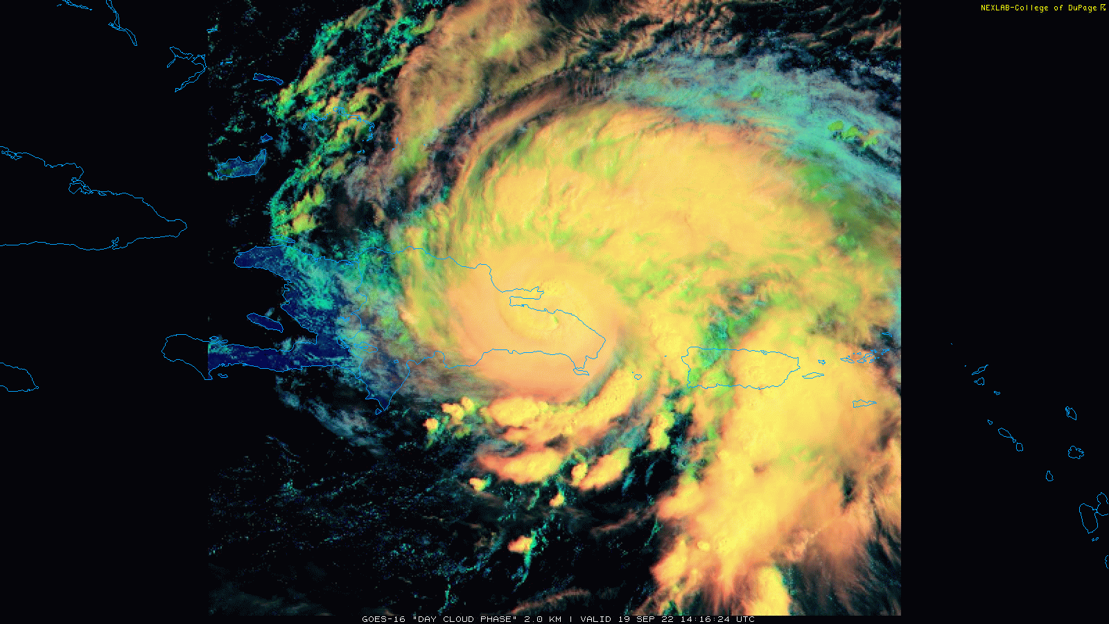
Hurricane Fiona has crossed over the eastern part of the Caribbean island of Hispaniola with heavy rainfall and powerful winds in Puerto Rico and the Dominican Republic. As the system pulls away from land and out over the warm waters of the western Atlantic Ocean, it’ll begin to strengthen and should attain “major” hurricane status later in the week as it turns to a northeasterly direction. Images courtesy College of DuPage, NOAA
Overview
Hurricane Fiona is crossing over the eastern side of Hispaniola this morning and is pounding away at the Dominican Republic and Puerto Rico with heavy rainfall, flash flooding and powerful winds. After moving away from land, Fiona will gradually make a turn during the next few days from its current northwest movement to north and then to the northeast ahead of an amplifying upper-level trough of low pressure that will build over the northeastern part of the nation. Fiona is likely to become the season’s first “major” hurricane during the next couple of days while out over the warm waters of the western Atlantic Ocean. The upper-level trough that will intensify over the northeastern states will help to keep Fiona away from the US east coast and will result in an outbreak of cool air late this week in the Great Lakes/Mid-Atlantic/Northeast US - the coolest air mass so far this season.
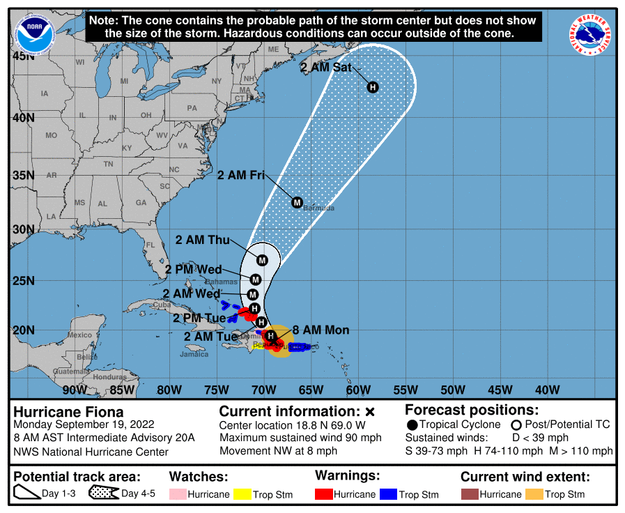
Hurricane Fiona is likely to become the season’s first “major” hurricane this week as is curves to the northeast ahead of an amplifying upper-level trough that will result in a late week cool blast for the Great Lakes/Mid-Atlantic/Northeast US. Map courtesy NOAA/NHC
Details
Hurricane Fiona continues to pound away at Puerto Rico and the Dominican Republic at this hour with heavy rainfall and powerful winds. As of 11am, Fiona featured sustained winds of 85 mph and was moving along in a northwest direction at about 8 mph. With its interaction of the island of Hispaniola, there has been some slight weakening of Fiona in the past few hours, but strengthening will take place once it moves away from land and out over the warm waters of the western Atlantic Ocean. In addition to the movement over the warm water which is favorable for intensification, atmospheric conditions will become more favorable as well over the next few days and Fiona is likely to reach “major” hurricane status (category 3 or higher ) as it heads to a position near Bermuda by the late week. This would be the first “major” hurricane so far in the overall rather quiet Atlantic Basin tropical season. Fiona is the 6th named storm of the 2022 tropical season…at the same time last year, there were 17 named storms.
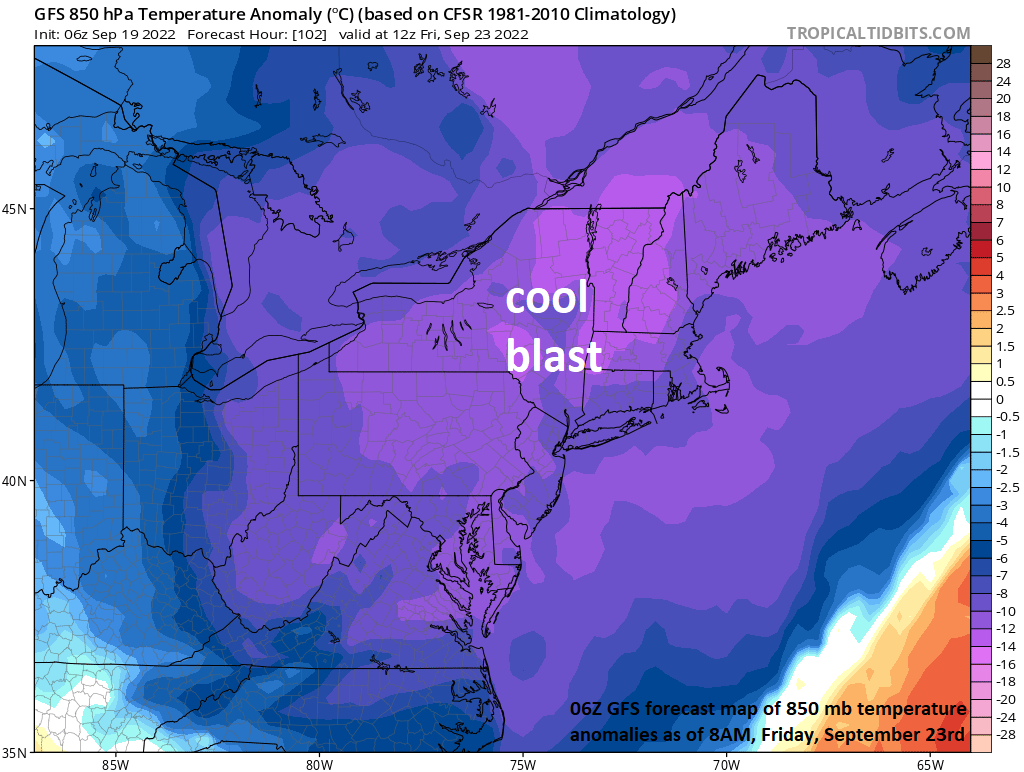
An impressive cool blast is headed to the northeastern part of the nation for the late week time period and the amplifying upper-level trough associated with it plays a key role in keeping Fiona away from the US east coast. Map courtesy NOAA, tropicaltidbits.com
One of the key factors in the “staying out-to-sea” track of Fiona in coming days will be an amplifying upper-level trough over the northeastern states. This intensifying upper-level trough will help to steer Fiona away from the US east coast and will become the catalyst for a much cooler-than-normal air mass to reach the Great Lakes/Mid-Atlantic/Northeast US by the latter part of the week. Down the road, this same upper-level trough could help to “absorb” Fiona and pull it back towards the Canadian Maritime provinces (e.g., Newfoundland) while the northeastern states experience an unusual cool blast. Temperatures on Friday could stay in the 60’s for highs all along the I-95 corridor and a stiff breeze from the north-northwest is possible as well with strong Canadian high pressure combining with the remnants of Fiona to generate a strong pressure gradient.
Meteorologist Paul Dorian
Arcfield
arcfieldweather.com
Follow us on Facebook, Twitter, YouTube
Video discussion: