11:45 AM | ***Western Atlantic storm…snow/ice eastern New England…California storms to wind down…large-scale pattern change unfolds across North America***
Paul Dorian

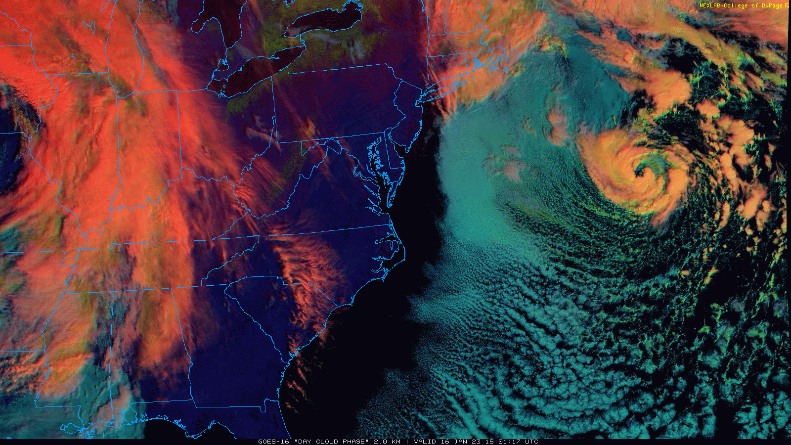
An “eye-like” feature has developed with a western Atlantic Ocean low that is creating snow and ice today across much of eastern New England. Images courtesy College of DuPage, NOAA
Overview
An active weather pattern continues across the nation on Monday with three different storm systems impacting the country. One storm has developed an “eye-like” feature over the western Atlantic Ocean and it is contributing to snow and ice today across much of eastern New England. A second system now over the middle of the country is generating rain on its warm side and accumulating snow in the cold sector. Meanwhile, California is getting pounded once again by a strong storm system and a weaker one is likely at mid-week. However, welcome relief is likely beyond that time as a large-scale pattern change unfolds across North America.
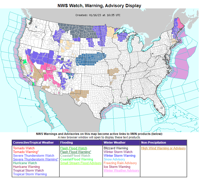
The NOAA “weather warnings” map today reflects three different storm systems that are impacting the US with multiple warnings in eastern New England, central/northern Plains and much of the western US.
“Eye-like” feature of western Atlantic storm…snow/ice eastern new England
It is currently snowing in Boston, Massachusetts which has been a rarity so far this winter season and snow and ice are impacting much of eastern New England from Rhode Island to Maine as a powerful storm system slowly moves over the western Atlantic Ocean. This storm has actually formed an “eye-like” feature at its core as it moves slowly over relatively mild ocean waters of the western Atlantic. Snow accumulations from this storm system will generally be limited to just 2 or 3 inches in much of eastern New England as sleet and freezing rain will be quite prevalent and a limiting factor.

Heavy snow will accumulate in the central Plains early this week amounting to 6-10 inches in many parts of Nebraska and northwestern Kansas. The stretch of accumulating snow from the storm now in the middle of the country will extend to the Upper Midwest over the next 48 hours or so. Meanwhile, snow continues to pile up in the Sierra Nevada Mountains of eastern California from the western storm and some will accumulate in eastern New England. Map courtesy Canadian Met Centre, tropicaltidbits.com
Central Plains storm will extend to the Upper Midwest
One of the recent storms to hit California has reached the middle of the country and it is holding its strength quite well and generating rain on its warm side and accumulating snow to the north and west of the storm track. In fact, accumulations of 6-10 inches are likely today/tonight in parts of the central Plains including much of Nebraska and northwestern Kansas. This low pressure system will push to the western Great Lakes on Tuesday with more accumulating snow to fall across the Upper Midwest. Rain is likely to reach the eastern states on Tuesday, but this will not be a significant event.
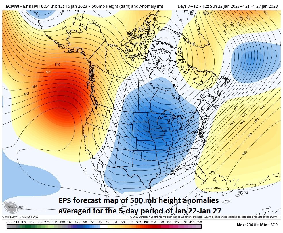
A large-scale pattern change will result in upper-level ridging from the eastern Pacific/western US and Canada to Alaska, an upper-level trough of low pressure will form over the central US/Canada, and ridging will persist over the western Atlantic Ocean. Map courtesy ECMWF, Weather Bell Analytics
California pounded again today…weaker system at mid-week and then welcome relief with large-scale pattern change
Yet another in a series of storms is impacting California today with heavy rainfall in low lying areas, heavy snow in the mountains, and strong winds throughout the Golden State. As has been the case with the most recent storms, localized flooding is a big concern given the already well-saturated grounds and strong winds can bring down some tree limbs with scattered power outages a continuing threat. After a break on Tuesday, another storm system is likely to arrive at mid-week. This next system, however, should be considerably weaker than the recent storms.
By later in the week, a large-scale pattern change will unfold across North America. This change in the upper atmosphere will feature high pressure ridging to extend from the eastern Pacific/US west coast northward to Alaska. As a result, the stormy pattern in California, Oregon and Washington will come to an end with protection from the developing ridge over the eastern Pacific Ocean. This pattern change will lead to other important changes as well across the nation. Specifically, an upper-level trough of low pressure will form over the central part of the US and Canada by early next week and likely slowly expand into the eastern states. A third feature on the weather maps by later next week will be persistent ridging of high pressure over the western Atlantic Ocean/Southeast US.

Colder-than-normal air may become quite widespread across the nation by later this month given the expected changes in the overall weather pattern. Map courtesy NOAA, tropicaltidbits.com
The combination of the upper-level ridge over the eastern Pacific Ocean and intensifying trough of low pressure in the middle of the country will set the stage for the transporting of cold air masses from northwestern Canada into the central US by early next week. The colder-than-normal air will then likely spread into the eastern states by later next week. While the west coast will quiet down in this evolving weather pattern, the central and eastern US will likely remain quite active going well into next week and with cold air getting involved, it’ll be a pattern to closely monitor in coming days.
Meteorologist Paul Dorian
Arcfield
arcfieldweather.com
Follow us on Facebook, Twitter, YouTube
Video discussion: