2:15 PM | **Cold shot arrives this weekend in the Mid-Atlantic region and others are likely to follow this month...Tropical Storm Philippe gets absorbed into the pattern-changing upper-level trough**
Paul Dorian
Temperatures between this afternoon and early Monday morning may drop some 40 degrees in the Mid-Atlantic region following the early weekend passage of a strong cold frontal system. Map courtesy NOAA, tropicaltidbits.com
Overview
Temperatures are some 10+ degrees above-normal today in the Mid-Atlantic region, but big changes are on the way this weekend and the change to noticeably cooler conditions may not be just an “in-and-out” affair. Strong upper-level ridging across the eastern US and Canada will give way to an upper-level trough of low pressure this weekend that will tend to hang around through much of October ensuring additional cold air outbreaks. This initial blast of much cooler air into the east will follow an early weekend strong cold frontal passage and Sunday promises to be the coolest day so far this fall season in the DC-to-Philly-to-NYC corridor. In addition to the cool down, winds will become an important factor by Sunday as the overall pressure gradient tightens across the northeastern states as Tropical Storm Philippe merges with the initial incoming upper-level trough system.
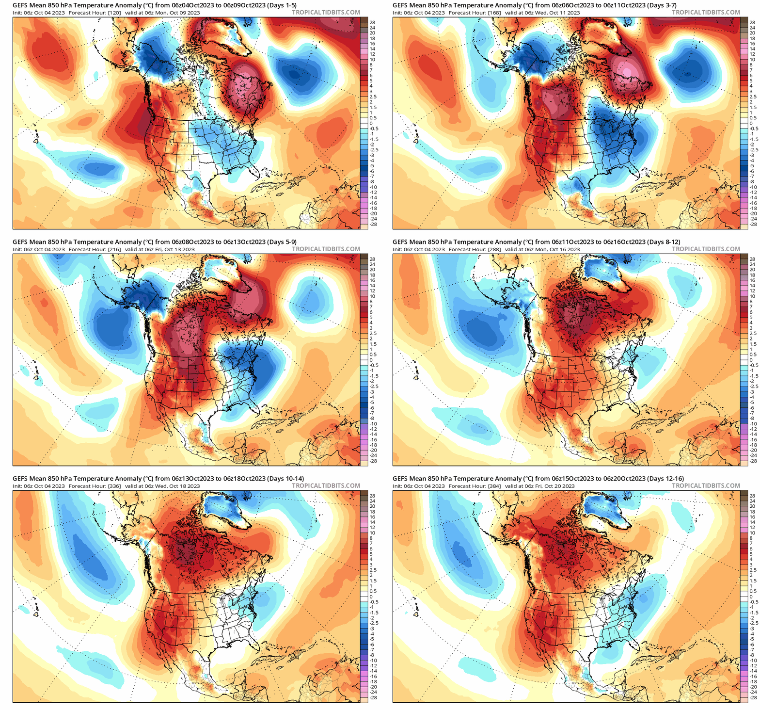
The 06Z GEFS forecast maps of 5-day mean 850 mb temperature anomalies going forward for the next couple of weeks show a transition from warmer-than-normal in the eastern states (shown in orange) to persistent cooler-than-normal conditions (shown in blue). Maps courtesy NOAA, tropicaltidbits.com
Details
Temperatures this afternoon will generally peak in the lower to middle 80’s across the I-95 corridor region from DC-to-Philly-to-NYC, but are likely to be some forty degrees colder by the time Monday morning rolls around. A strong cold front will pass through the eastern states on Saturday and will usher in much cooler air for the second half of the upcoming weekend. In fact, high temperatures on Sunday afternoon may be confined to the 50’s in parts of the DC-to-Philly-to-NYC corridor and there will be a strong NW wind making it feel even colder than the actual air temperature.
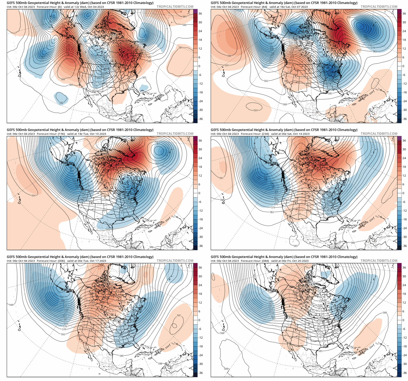
The 06Z GEFS forecast maps of 500 mb height anomalies going forward for the next couple of weeks show a transition from ridging of high pressure in the eastern states (shown in orange) to persistent upper-level troughing of low pressure (shown in blue). This transition aloft will lead to a cooler pattern across the eastern US that begins this weekend and may last well into the month of October. Maps courtesy NOAA, tropicaltidbits.com
The upper air pattern in recent days has featured strong ridging of high pressure in eastern US and Canada contributing to well above-normal weather during the first half of the week in the Mid-Atlantic. Over the weekend, big-time changes will take place aloft as an intensifying upper-level trough of low pressure will cross the Great Lakes and position itself over the Northeast US by Sunday morning.
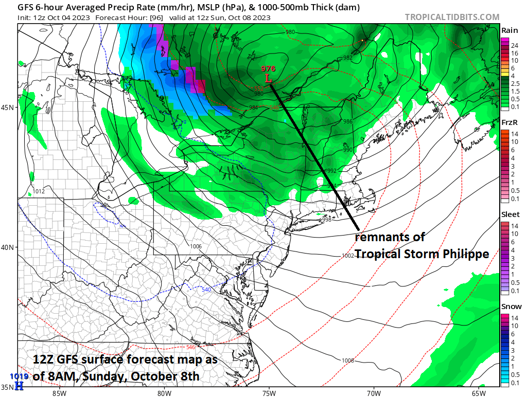
The state of Maine is liable to be impacted by another tropical storm this weekend and the remnants of TS Philippe will get “absorbed” into the incoming upper-level trough of low pressure. As a result, the overall pressure gradient field will tend across the northeastern states on Sunday assuring the formation of strong NW winds to close out the weekend. Map courtesy NOAA, tropicaltidbits.com
This initial upper-level trough of low pressure will tend to “absorb” the remnants of Tropical Storm Philippe later this weekend and the result will be a tightening pressure gradient across the northeastern states assuring the development of strong NW winds. After that, the large-scale upper-level trough will tend to spin around for much of next week in the eastern US assuring cool weather will continue for an extended period of time.
After a very warm start to the month, October may turn out to be cooler-than-normal in much of the eastern US given an expected significant pattern change. Map courtesy Weather Bell Analytics, NOAA
In fact, there are signs that the third week of the month may also feature troughing in the eastern states and this increases the odds that October will turn out to be a cooler-than-normal month as a whole across much of the eastern US. At the same time the east experiences persistent cool weather, ridging of high pressure is likely to dominate the scene across the western US with consistent warmer-than-normal temperatures.
Meteorologist Paul Dorian
Arcfield
arcfieldweather.com
Follow us on Facebook, Twitter, YouTube
Video discussion:


