
4:15 PM | ****Low pressure to intensify on Monday off the Mid-Atlantic coastline reaching near Long Island by mid-day Tuesday…snow on Tuesday can swing all the way down into SE PA and southern NJ****
Paul Dorian
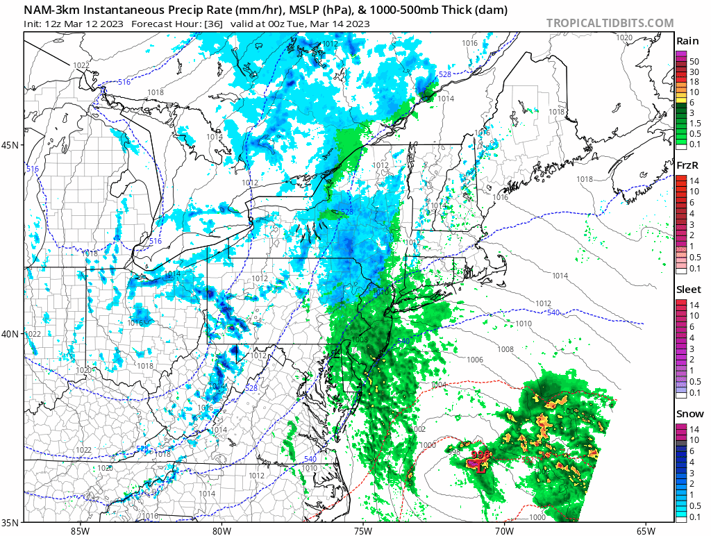
The high-resolution version of the NAM features an inverted trough extending back to the coast from the center of the oceanic low. This trough can play an important role in the movement and enhancement of a band of snow on Tuesday swinging from northeast-to-southwest and perhaps generating accumulations all the way down into southeastern PA and southern NJ. There is even an outside chance that some snow makes its way into northern Maryland. Maps courtesy NOAA, tropicaltidbits.com
Overview
It was thirty years ago that the so-called “Storm of the Century” pounded the eastern US all the way from Florida to Maine after what was a relatively quiet winter season of 1992-1993. In much the same manner, this winter season has been relatively quiet as well in much of the Mid-Atlantic/Northeast US in terms of cold and snow. However, as was the case thirty years ago, it looks like there will be a late winter March storm that years from now could make this relatively mild winter much more of a memorable season…at least for many of those in the Northeast US.

The ultimate positioning of the upper-level low on Tuesday will play a big role on how far to the south and west snow can wrap around the intense surface low off the Mid-Atlantic coastline. Map courtesy NOAA, tropicaltidbits.com
Details
While this potential early week storm will not impact the US east coast all the way from Florida-to-Maine as did the “Storm of the Century” thirty years ago, it could have a big impact on the Northeast US and likely all the way down to the northern Mid-Atlantic including NYC, much of eastern PA and NJ. This early week storm system which is supported by a vigorous upper-level low began its journey by pounding away at California on Friday and Saturday with tremendous snowfall in the higher elevations, excessive rainfall in coastal/low-lying areas, and powerful winds that caused power outages in some areas. That same upper-level low has pushed from the west coast on Friday to the Northern Plains on Sunday and it will drop southeastward over the next couple of days helping to form a powerful storm system just off the east coast.

Significant snow is likely from this upcoming storm across NE PA, Lower Hudson Valley of NY State and central/western MA and CT in New England. Snow may swing all the way down into southeastern PA and southern NJ due to an inverted trough extending to the coast from the center of the oceanic low. Map courtesy NOAA, tropicaltidbits.com
Precipitation has broken out today in parts of the Mid-Atlantic region and will continue into Monday mainly in the form of rain in the DC-to-Philly-to-NYC corridor and mainly snow in the usual favored interior higher elevation locations. The surface low will push northeastward on Monday just off the Mid-Atlantic coastline and ending up near Long Island by mid-day on Tuesday. Heavy snow is likely to break out by Monday night across much of New York State and interior New England as this system intensifies off the coast. Colder air will wrap into the system and any rain or mixture that is falling early Monday night in the I-95 corridor region from Philly-to-NYC can very well change to snow by early Tuesday.
Accumulating snow is likely in the NYC metro region and there can be accumulations all the way south into southeastern PA and southern New Jersey by later Tuesday by as an inverted trough extending back from the ocean low pressure center will enhance precipitation amounts back into this zone. There is even an outside chance that some snow swings around from northeast-to-southwest all the way down to the northern part of Maryland on Tuesday. Significant accumulating snow of a foot or more is likely from this storm system across NE PA and interior NW NJ. The real “bullseye” region in terms of snowfall from this storm may end up being the Lower Hudson Valley of NY State and central/western sections of Connecticut and Massachusetts. Winds will become an important factor as well by later Monday night through Tuesday night with 50 mph wind gusts possible on Tuesday throughout the Mid-Atlantic region on the back side of this powerful storm and scattered power outages are on the table.
Stay tuned…still plenty of details that have to be ironed out, but as we learned thirty years ago, there is precedent for big-time late winter snowstorms.
Meteorologist Paul Dorian
Arcfield
arcfieldweather.com