12:45 PM **An active and colder pattern…snow late tonight/early Tuesday across portions of PA/NJ…additional threats in the Mid-Atlantic region early this weekend and perhaps again early next week**
Paul Dorian
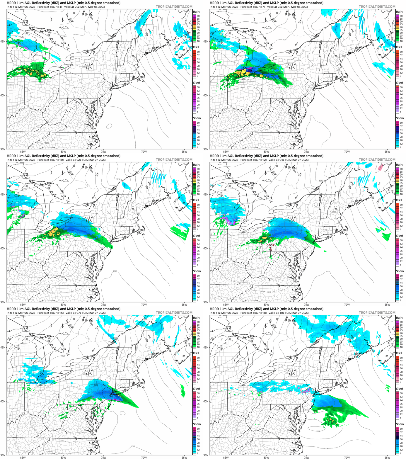
Fast-moving low pressure will generate a swath of accumulating snow late tonight into early Tuesday across portions of upstate Pennsylvania and western New Jersey. Maps courtesy NOAA, tropicaltidbits.com
Overview
The overall weather pattern will remain quite active in the Mid-Atlantic region during the next several days with one quick-moving system late tonight and there can be additional threats both early this weekend and early next week. This initial system can generate snow or rain changing to snow from late tonight into early Tuesday across portions of upstate Pennsylvania and western New Jersey and some higher-elevation spots can receive as much as 3-6 inches by daybreak. The overall weather pattern is turning colder due in large part to significant high-latitude blocking that has developed over northern Canada/Greenland and to a disappearing stubborn ridge over the southern US.
This forecast map of total snowfall by early Tuesday comes from a high-resolution forecast model known as the HRRR. Map courtesy NOAA, tropicaltidbits.com
Details
There has been persistent high-pressure ridging centered often over the southeastern states in recent weeks and this system has been a key factor in the overall warmer-than-normal weather for much of the central and eastern US. This stubborn ridge is about to disappear – at least on a temporary basis – at the same time high-latitude blocking locks in over northern Canada and Greenland. This combination will allow for further penetration of Canadian cold air masses into the central and eastern states in coming days which, in turn, will lead to a better chance for snow in the Mid-Atlantic region and Northeast US.
The current 500 mb height anomaly pattern across North America indicates strong high-latitude blocking over northern Canada/Greenland (purple; much higher heights than normal) and ridging (orange, slightly higher heights than normal) across the southern US which has been a persistent feature in recent weeks. Map courtesy NOAA, tropicaltidbits.com
In fact, there will be a chance of snow in limited portions of the Mid-Atlantic region from later tonight into early Tuesday. A fast-moving “clipper-like” low pressure system will travel from northwest-to-southeast later tonight and a swath of accumulating snow is likely to be the result from northwestern PA to west-central New Jersey. In fact, some of the upstate higher elevation locations in PA can see as much as 3-6 inches of snow by daybreak Tuesday. On the outer edges of the main snow band, the Philly and NYC metro region can see a bit of snow or rain-changing-to-snow with a coating to an inch on the table in suburban locations.
In areas south of the PA/MD border (e.g., DC metro region), this system will have little to no impact with nothing more than a few rain showers possible. This low pressure system will clear the east coast by mid-morning and winds will increase markedly in the DC-to-Philly-to-NYC corridor with gusts later tomorrow of 40+ mph on the table. The strong winds will continue on Tuesday night and Wednesday as well in the Mid-Atlantic/NE US.
The 500 mb height anomaly pattern across North America in one week’s time (Monday, March 13th) will likely still feature high-latitude blocking over northern Canada/Greenland, but the southern US ridge will virtually disappear leading to a colder central and eastern US compared to recent days. Map courtesy NOAA, tropicaltidbits.com
By the early part of the weekend, another upper-level low will travel across the northern states and it is likely to result in the formation of low pressure somewhere off the Mid-Atlantic coastline by Friday night or Saturday. It is too early to determine how much precipitation can fall in the Mid-Atlantic/NE US from this system and the precipitation type (i.e., rain or snow) is also an uncertainty at this vantage point.
Snowfall across North America (left) and the Northern Hemisphere (right) has reached levels well above-normal for this time of year. Maps courtesy Environment Canada
There may be a repeat performance early next week with another upper-level low system pushing across the northern US and it too can spawn the development of low pressure somewhere near the Mid-Atlantic coastline.
Both of these systems will need to be closely monitored in coming days...stay tuned.
Meteorologist Paul Dorian
Arcfield
arcfieldweather.com
Follow us on Facebook, Twitter, YouTube
Video discussion:


