
12:00 PM | ***An active, colder pattern…MJO, high-latitude blocking…storm threats for the Mid-Atlantic/Northeast US at week's end and again early next week***
Paul Dorian

The Madden-Julian Oscillation tracks a tropical disturbance that propagates around the world on a regular basis. Depending on its phase in a particular time of year, this teleconnection index can give clues as to upcoming temperatures patterns in the US. In this case, Phase 8 and Phase 1 tend to correlate with colder-than-normal conditions across much of the central and eastern US and that is forecasted by this particular computer forecast model (JMA) in coming days. Plot courtesy Japan Meteorological Agency/NOAA
Overview
The overall weather pattern will remain quite active during the next several days with storm threats possible in the Mid-Atlantic/Northeast US both at week’s end and again early next week. The overall weather pattern is also turning colder due in large part to significant high-latitude blocking that has developed over northern Canada/Greenland in response to recent stratospheric warming and to the likely upcoming disappearance of a stubborn ridge over the southern US.
Colder pattern, MJO
There has been persistent high-pressure ridging in recent weeks often centered over the southeastern states and this system has been a key factor in the overall warmer-than-normal weather for much of the central and eastern US. This stubborn ridge is about to disappear – at least on a temporary basis – at the same time high-latitude blocking locks in over northern Canada and Greenland. The high-latitude blocking is a tropospheric response to a recent stratospheric warming event and can very well have an impact on the nation’s temperatures for at least the next few weeks. This combination of high-latitude blocking and a disappearing southern US ridge will allow for further penetration of Canadian cold air masses into the central and eastern states which, in turn, will lead to better chances for snow in the Mid-Atlantic region and Northeast US beginning as early as late this week.
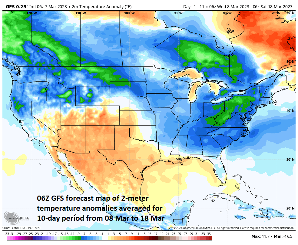
The 10-day period from 08 March to 18 March is forecasted by the 06Z GFS to feature a lot of colder-than-normal weather across the eastern half of the nation. Map courtesy NOAA, Weather Bell Analytics
Supporting evidence for a colder weather pattern across much of the nation comes from a teleconnection index value known as the Madden Julian Oscillation or MJO. The MJO can be characterized as an eastward moving “wave” or “pulse” of clouds and enhanced tropical rainfall near the equator that typically recurs every 30-to-60 days. One method meteorologists use to monitor the MJO is in an 8-phase diagram whereby each phase coincides with locations along the equator. In addition to being informative about the location of the MJO, these phase diagrams provide some information as to the strength of the tropical disturbance as it traverses the tropics. Specifically, when the MJO index is within the center circle of the forecast plots, it is considered to be weak and when it is outside, it is stronger and usually moves in a counter-clockwise direction. The different phases of the MJO correlate well with different temperature and precipitation patterns around the world depending on the given time of year.

The Madden-Julian Oscillation (MJO) is forecasted to go through Phase 8 (lower right) and then Phase 1 (upper left) in coming days. Temperature composites from numerous prior MJO events show that these tow phases are usually correlated with colder-than-normal weather across much of the eastern half of the nation in this time of year. Map courtesy NOAA
The current forecast by the Japan Meteorological Agency (JMA) computer forecast model indicates the MJO will be very strong over the next several days (i.e., well away from the center circle) and will rotate in a counter clock fashion through Phase 8 and then into Phase 1. These two phases of the MJO are pretty well correlated with colder-than-normal conditions in the central and eastern US this time of year using empirical observations from prior MJO events.

One storm threatens the Mid-Atlantic/NE US with rain and snow in the Friday/Saturday time frame. The primary (initial) low pressure system is likely to weaken over the northern Ohio Valley and then a secondary will intensify just off the Mid-Atlantic coastline by late Friday or early Saturday. Map courtesy Canadian Met Centre, tropicaltidbits.com
Storm threats
By the end of the work week, surface low pressure is likely to head to the northern Ohio Valley and similar to some recent systems, this primary (initial) low is likely to weaken and a secondary system may form somewhere just off the Mid-Atlantic coastline. It is this second low pressure system that will become the main player in the Mid-Atlantic region/NE US by late Friday or early Saturday. It is too early to tell exactly where this western Atlantic low may form and how quickly it can intensify – two important details that have to be ironed out in coming days. The potential does exist for some accumulating snow by week’s end in at least the usual favored areas across interior sections of the Mid-Atlantic and NE US. In the immediate I-95 corridor from DC-to-Philly-to-NYC, a possible scenario is for rain to fall initially, but then as the primary low fades and secondary takes over, a changeover to snow will be possible.

The 00Z EPS model run for the storm threat early next week depicts several features that snow lovers in the Mid-Atlantic/NE US would like to see as they are favorable for snow prospects. Specifically, the Euro forecast from this vantage point (and that is still several days away) depicts the following: 1) high-latitude blocking over Canada, 2) a deep trough in the eastern US, 3) high pressure ridge axis through the interior western US, and finally 4) an upper-level low near the “50/50” (latitude/longitude) benchmark …all of which are usually favorable for snow in at least parts of the Mid-Atlantic/NE US. Map courtesy Weather Bell Analytics/ECMWF
By the early part of next week, there may be a repeat performance in that a primary (initial) low pressure system may head to the northern Ohio Valley, weaken, and then a secondary system forms just off the Mid-Atlantic coastline. The details for this second threat likely won’t be known until the weekend as they could largely depend on the actions of the first system likely in the Friday/Saturday time period. As in the case for the system at the end of the work week, threat “number 2” has the potential for some accumulating snow in at least in the usual favored areas of the interior Mid-Atlantic and NE US and perhaps again a rain-changing-to-snow scenario in the I-95 corridor.

A second storm system threatens the Mid-Atlantic/NE US early next week with rain and snow. In a similar fashion to the Friday/Saturday threat, this second one may feature a primary (initial) low pressure system that weakens over the northern Ohio Valley which would then be followed by the formation of a secondary low pressure intensifying somewhere off the Mid-Atlantic coastline. Map courtesy Canadian Met Centre, tropicaltidbits.com
Stay tuned…the overall pattern remains active, is turning colder, and will soon get quite interesting.
Meteorologist Paul Dorian
Arcfield
arcfieldweather.com
Follow us on Facebook, Twitter, YouTube
Video discussion: