
12:45 PM | ****Active, colder pattern with multiple storm threats… possible burst of snow early Saturday eastern PA/NJ with inverted trough...second system can become a monster storm for NE US****
Paul Dorian

An inverted trough and rapid intensification can lead to a burst of heavier snow early Saturday across eastern PA, New Jersey, and NYC. Map courtesy NOAA, tropicaltibits.com
Overview
The overall weather pattern will remain quite active across the nation during the next couple of weeks with most sections experiencing colder-than-normal conditions. In the Mid-Atlantic/Northeast US, there may be as many as three storms during the next week or so presenting chances of rain and snow. The first threat of rain and snow will come from Friday into Saturday, the second system from late Sunday into Tuesday and this could turn into a monster storm for the NE US, and the potential exists for a third storm around the end of next week. In all cases, the most favored areas for accumulating snow will be the usual interior, higher elevation locations, but even the I-95 corridor can get some accumulating snow; especially, to the north and west of the big cities. One interesting aspect about the first storm, it will likely feature an inverted trough extending from the low pressure center over the western Atlantic to the Mid-Atlantic coastline early Saturday and will undergo rapid intensification…both of which can lead to a last minute burst of heavier snow in such places as eastern Pennsylvania and New Jersey.
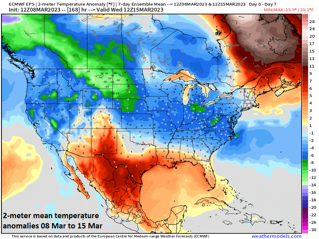
Colder-than-normal weather will occur across much of the nation taking us to the middle of the month of March. This pattern was set in motion by a stratospheric warming event in February and subsequent (and still on-going) high-latitude blocking. Map courtesy weathermodels.com (Dr. Ryan Maue, Twitter), NOAA
Friday/Saturday storm
An active and colder-than-normal weather pattern will continue for much of the nation during the next couple of weeks with California continuing to get pounded and likely multiple rain/snow threats in the Mid-Atlantic/NE US. The systems impacting California will bring more substantial snowfall to the Sierra Nevada Mountains on top of what is already an extremely deep snow pack and there will be significant rainfall in low-lying/coastal areas. The first of the systems to impact the Mid-Atlantic/Northeast US will come from tomorrow morning/mid-day into Saturday with rain or snow depending on time and location. Low pressure will move to a position over Ohio by early Friday morning and precipitation is likely to break out by mid-morning from central Virginia and the DC metro region northward into central Pennsylvania. The precipitation is likely to reach the eastern part of PA including the Philly metro region during the early afternoon hours on Friday and then New York City by late afternoon. In all of these I-95 metro regions, the precipitation during the day on Friday may go back and forth between rain and snow or simply be a mix with any possible small accumulations likely confined to grassy surfaces in the northern and western suburbs.
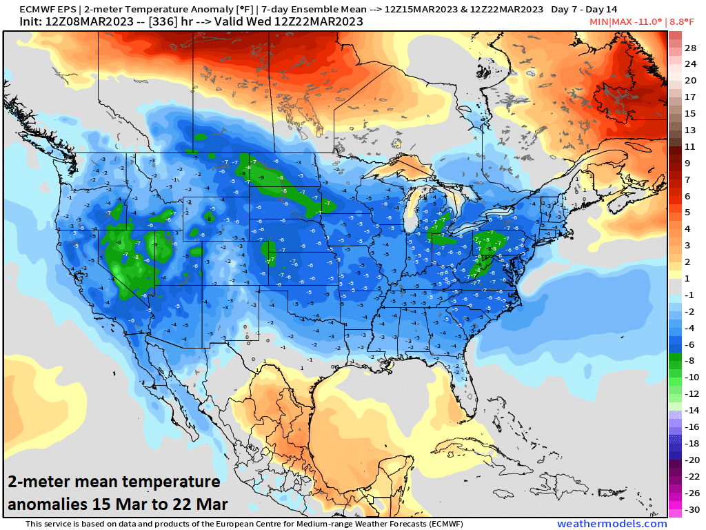
Not only will the next week be colder-than-normal across much of the nation, but so will the week of March 15-22. Map courtesy weathermodels.com (Dr. Ryan Maue, Twitter), NOAA
By late Friday, the initial surface low pressure system over Ohio will dissipate and a secondary low pressure system will start to take shape near the Carolina coastline and it’ll soon become the main player. In fact, this western Atlantic low will intensify quite rapidly from late Friday night into early Saturday and this strengthening will allow for colder air to wrap into the system from northwest-to-southeast. This influx of colder air later tomorrow night will be an important factor as it will likely result in a changeover of rain or a mix of rain and snow to all snow in places like eastern PA and interior New Jersey.
By late Friday night and early Saturday, there will be an inverted trough extending from the center of the oceanic low pressure area back to the Mid-Atlantic at the same time rapid intensification takes place. This combination could generate a burst of heavier snow early Saturday across places like eastern PA and New Jersey which, in a worst case scenario, could dump a couple-to-few inches in some spots…something to be prepared for early Saturday.

A second system will impact the Mid-Atlantic region and Northeast US from late Sunday into Tuesday and it could very well develop into a monster storm by Monday night or early Tuesday somewhere near the New England coastline. Map courtesy Canadian Met Centre, tropicaltidbits.com
Monster storm threat early next week
By Sunday night and Monday, another system will impact the Mid-Atlantic/NE US with rain and snow. This second system is likely to have much more support in the upper atmosphere compared to the first allowing it to “dig” farther to the south and east on the front side and then climb farther to the north and east on the back end. In fact, this second system could become an all-out monster storm by late Monday or early Tuesday somewhere near or along the Northeast US coastline…perhaps classifying as a “bomb cyclone” with its expected rapid and significant intensification. This second system is clearly something to closely monitor in coming days and if it develops quicker than currently expected, it could end up having a major impact on the northern Mid-Atlantic region in addition to the Northeast US.
From this vantage point, it looks like precipitation could break out in the Mid-Atlantic region with this second system late Sunday afternoon or Sunday evening and continue into Monday and once again, odds for snow and accumulations will be higher in the usual favored interior higher elevation locations, but cannot be ruled out in the immediate I-95 corridor. Heavy snow is possible in much of New York State and New England by the time we get to late Monday and again, the northern Mid-Atlantic region may end up in the threat zone as well….stay tuned.
Looking ahead, there are signs that yet another storm system crosses the country next week and it may present a third opportunity for rain and snow in the Mid-Atlantic/NE US sometime in the late Friday/Saturday time frame…a lot of time to monitor that threat.
Meteorologist Paul Dorian
Arcfield
arcfieldweather.com
Follow us on Facebook, Twitter, YouTube
Video discussion: