10:45 AM | ***Active weather pattern continues into May…severe weather threat on Thursday along Gulf coast…back-to-back soaking rain events Mid-Atlantic/Northeast US from Friday into Monday***
Paul Dorian
Deep upper-level low will likely become situated over the eastern Great Lakes come Monday morning and this will then tend to spin around for a few days bringing unsettled and unusually chilly conditions to the Great Lakes, Midwest, Mid-Atlantic and Northeast US…just as the month of May begins. Map courtesy ECMWF, Pivotal Weather
Overview
An active weather pattern will continue across the nation into early May largely fueled by the continuation of cold air outbreaks from Canada into the US. One such cold shot will push east on Thursday from the south-central states into the northern Gulf region and this “clash” between the incoming cold, dry air and the entrenched warm, humid air mass is likely to result in strong-to-severe thunderstorm activity from Texas-to-Florida and perhaps as far north as the Tennessee Valley.
This storm system will push northeast on Friday and a secondary storm will form near the Mid-Atlantic coastline later Friday night. A similar scenario will develop from Sunday into Monday with an initial (primary) low pushing towards the Great Lakes and a secondary storm likely to form near the northeastern US coastline. The end result…back-to-back soaking rain events for the Mid-Atlantic/Northeast US from Friday into Monday.
Following the passage of the second storm system, very chilly air for early May will flood the northeastern quadrant of the country for the Monday-to-Wednesday time period and the atmosphere will be quite unstable. As a result, there are likely to be some instability rain showers during the first half of next week and snowflakes and/or ice pellets can mix in across some of the higher-elevation, interior locations of the Mid-Atlantic/Northeast.
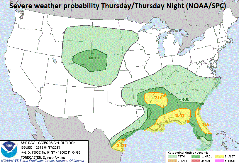
Severe weather is a threat today across the Deep South and Tennessee Valley. Map courtesy NOAA/Storm Prediction Center.
Details
The combination of cold, dry air advancing east into entrenched warm and humid air and support from a strong vorticity max (spin in the atmosphere) will increase chances for strong-to-severe thunderstorm activity in the Gulf Coast States later Thursday and early Thursday night. This threat for severe weather will extend from Texas-to-Florida and perhaps as far north as the Tennessee Valley. The severe weather threat will include the possibility of damaging wind gusts, torrential rainfall, hail, and even isolated tornadoes. This upper-level wave of energy will push to the northeast during the next 24 hours and surface low pressure will push to the northern Ohio Valley by mid-day Friday.
Severe weather is possible on Thursday across the Gulf Coast states from Texas-to-Florida and the threat can extend northward to the Tennessee Valley. One of the culprits for the possible severe weather will be the advancement to the east of a cold, dry air mass across the southern US that will “clash” with an entrenched warm and humid air mass in the northern Gulf region. Map courtesy ECMWF, Pivotal Weather
Rain associated with this northeastward moving storm system will spread into the Mid-Atlantic region during the day on Friday and it can become heavy at times going into and then through Friday night. A secondary low pressure system will form near the Mid-Atlantic coastline by late Friday night intensifying the rainfall and helping to tighten the overall pressure gradient field. Winds will intensify from an east or southeasterly direction on Friday night potentially leading to coastal flooding at times of high tides from NYC/Long Island-to-New Jersey-to-the Delmarva Peninsula. On Saturday, the soaking rain will spread to New England and occasional rain or drizzle will linger in the Mid-Atlantic region.
Back-to-back soaking rain events over the next five days will result in plentiful precipitation across much of the eastern US with several inches on the table in some areas. Map courtesy ECMWF, Pivotal Weather
By the time we get to the second half of the weekend, a multitude of upper-level lows will begin to consolidate into one as the northernmost system will become the dominant player and act to “absorb” the other upper-level lows. The end result will be one deep upper-level low by the early part of next week centered over the eastern Great Lakes. At the surface (and very similar to the first setup on Friday and Saturday), an initial (primary) low will push towards the Great Lakes and a secondary storm will form near the Mid-Atlantic coastline by late Sunday night/early Monday. As with the first event, this second one will result in soaking rains for the Mid-Atlantic/Northeast US and winds will become quite a noticeable factor as well.
An unusually chilly air mass for the first few days of May will dominate the scene next week across the Great Lakes, Midwest, Mid-Atlantic and Northeast US. Map courtesy ECMWF, Pivotal Weather
The deep upper-level low over the Great Lakes early next week will tend to spin around for a few days and this will result in unstable and unusually chilly conditions across the Great Lakes, Midwest, Mid-Atlantic and Northeast US. Scattered “instability” rain showers will be possible from time-to-time in the Monday-to-Wednesday time period and the air may be just cold enough for some snowflakes or ice pellets to mix in across some of the higher-elevation, interior locations of the northeastern states…not the best of starts for the month of May.
Meteorologist Paul Dorian
Arcfield
arcfieldweather.com
Follow us on Facebook, Twitter, YouTube
Video discussion:


