10:45 AM | ***Overall weather pattern continues to bring smoke to the Mid-Atlantic along with comfortable temperatures and low humidity…glimmer of hope for a decent rainfall early next week***
Paul Dorian
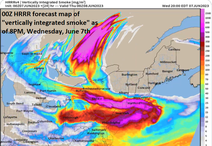
Smoke from wildfire activity in Quebec, Canada will continue to push into the Mid-Atlantic region on Wednesday afternoon and evening as persistent northwesterly flow continues on the back side of an upper-level low over the northeastern states. In fact, the the smoke headed this way for the PM hours on Wednesday may be the densest of all so far for NYC, Pennsylvania and New Jersey and the smell of smoke will become more noticeable. Map courtesy NOAA/WPC
Overview
It is quite common to have a “Bermuda High” type of weather pattern in the eastern US this time of year with high pressure stationed over the western Atlantic and southwesterly flow of air pushing hot and humid air to the Mid-Atlantic region from the Gulf of Mexico. Our current weather pattern is about as opposite as you can get with a meandering upper-level low centered over Maine/Nova Scotia leading to persistent northwesterly flow in the lower part of the atmosphere. This type of wind flow is influencing the weather in multiple ways.
First, it is leading to quite comfortable temperatures in the Mid-Atlantic region for the early part of June and, second, it is resulting in unusually low humidity levels. In addition, this persistent northwesterly flow continues to bring smoke into the area from wildfires that developed several days ago in Quebec, Canada. In fact, the most dense smoke of all in this current outbreak may push into New York City, Pennsylvania and New Jersey this afternoon and evening and the smell of smoke should become much more noticeable. In terms of rainfall, there were scattered late day showers and thunderstorms on Tuesday and a couple of troughs can bring isolated showers/thunderstorms to the Mid-Atlantic region later in the week. Looking ahead, there is a glimmer of hope for a more appreciable rainfall early next week with another upper-level low likely to spin into the Mid-Atlantic region from the Great Lakes.
This overall weather pattern has not only resulted in smoky skies in the Mid-Atlantic region, but also cooler-than-normal temperatures. Maps courtesy NOAA, tropicaltidbits.com
Details
The moon and sun have taken on an orange appearance in recent days thanks to smoke-filled skies that have resulted from northwesterly winds and wildfire activity across Quebec, Canada. An upper-level low has meandered for days over the far northeastern corner of the US and the Canadian Maritime Provinces and northwesterly flow has persisted on its back side in the Mid-Atlantic region. The downside of this flow of air is that it has pushed smoke from northwest-to-southeast (i.e. from southeastern Canada into the NE US) and helped to reduce air quality. In fact, the most dense smoke of all during this current outbreak may reach New York City, Pennsylvania and New Jersey from the north this afternoon and last into the evening. The upside with this overall scenario is that this same flow of air has resulted in very comfortable temperatures for the Mid-Atlantic region and low humidity levels with dew points in the 30’4 and 40’s along the I-95 corridor. Often in June, southwesterly flow persists bringing hotter and much more humid air to the region from the Gulf of Mexico…not so far this month or at anytime during the month of May.
Persistent northwesterly flow has brought low humidity air into the Mid-Atlantic region with dew points - a direct measure of overall humidity levels - into the 40’s on Wednesday which is not too common for the month of June. Map courtesy NOAA, tropicaltidbits.com
This overall weather pattern has resulted in relatively rain-free weather for the Mid-Atlantic region during the past few weeks and lawns are turning brown as a reflection of this extended dry spell. A frontal system did spark isolated showers and thunderstorms late yesterday, but the air mass was so dry, some of the rain which was limited in scope to begin with, failed to even reach the ground. Another couple of spokes of energy will rotate around this still meandering upper-level low over the northeastern states on Thursday and Friday and these can produce scattered showers and thunderstorms.
There is some hope for beneficial rain early next week in the Mid-Atlantic region as another upper-level low will spin its way from the Great Lakes to the Mid-Atlantic/NE US at the same time surface low pressure forms along a frontal boundary zone. Map courtesy NOAA, tropicaltidbits.com
Looking ahead, perhaps the best chance in awhile for any appreciable rainfall will come early next week as a frontal system moves from west-to-east across the Midwest and likely stalls as it approaches the Mid-Atlantic region. As it does so, low pressure may form along the frontal boundary zone just to the west of here and this, in turn, will turn our low-level flow of air to more of a southwesterly direction. This would help to increase moisture content in the atmosphere and it could just result in some decent rainfall around here during the early part of next week…something that has been missing in action in recent weeks.
Meteorologist Paul Dorian
Arcfield
arcfieldweather.com
Follow us on Facebook, Twitter, YouTube


