
11:15 AM | *Strong high pressure will be in control in the Mid-Atlantic/NE US for the next several days and that is to include the long holiday weekend…comfortable summer season ends on a nice note*
Paul Dorian
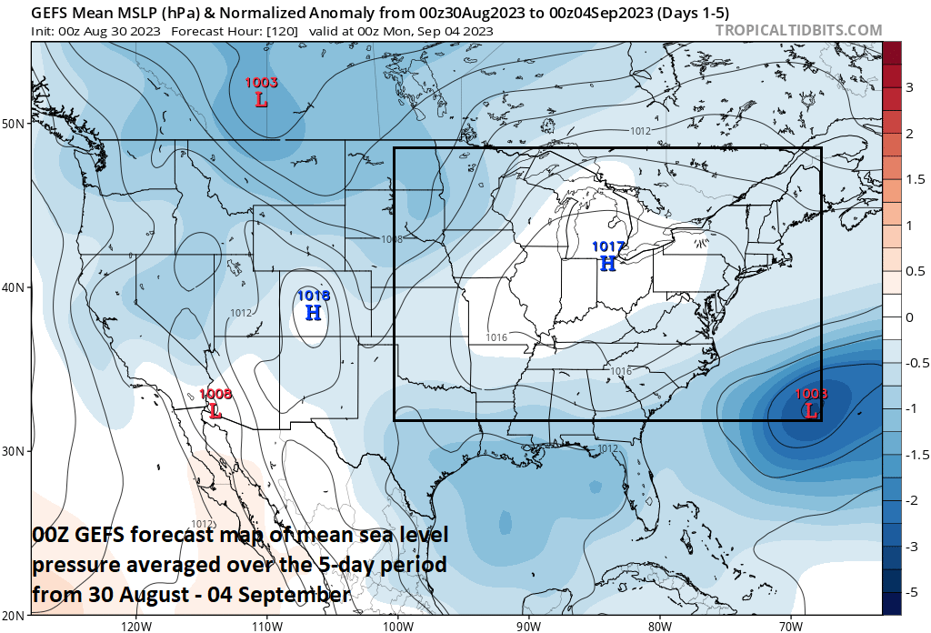
High pressure will be the dominant feature in the Mid-Atlantic/NE US during the next several days. Map courtesy NOAA, tropicaltidbits.com
Overview
Most would agree that the timing couldn’t be any better. In what has been an overall very comfortable summer in the Mid-Atlantic/Northeast US, the traditional end to the season will feature strong high pressure in control leading to an extended stretch of dry weather to include the Labor Day holiday weekend. Temperatures will start off very comfortable for the first part of this period; however, they’ll climb to very warm levels by the early part of next week.
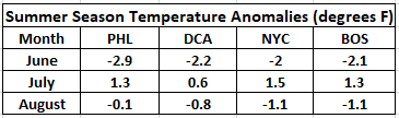
The meteorological summer season of June 1st - September 1st has been quite comfortable in the Mid-Atlantic/Northeast US with slightly below-normal temperatures overall for June, July and August. Data courtesy NOAA/NWS (August data through August 29th)
Details
With only one more day to go, the meteorological summer season of June 1st – September 1st has been quite nice across the Mid-Atlantic region and Northeast US with slightly below-normal temperatures overall when averaging together the months of June, July and August. (Astronomical summer season typically runs from June 21st to September 21st). Perhaps it is therefore only fitting that the traditional end to the summer season this year – the upcoming long Labor Day holiday weekend – features strong high pressure in control and an extended stretch of dry weather.

On the frontside of strong high pressure, temperatures will be normal to below-normal in the Mid-Atlantic region and Northeast US from later this week into the beginning of the upcoming weekend. Map courtesy NOAA, tropicaltidbits.com
A cold front has slid through the I-95 corridor on Wednesday morning generating showers and embedded thunderstorms and skies will clear later in the day leading to a pleasant night with comfortably cooler conditions. High pressure on Thursday will be positioned over the Great Lakes and it will strengthen and slowly migrate to the east as we wind down the month of August. This same high pressure system will help to prevent the remains of Hurricane Idalia from advancing any farther north than the state of North Carolina and those remnants will then get swallowed up by the ridge and meander off the east coast for several days. There may be a stiff breeze on Thursday around here with the strong pressure gradient between the incoming high pressure system and the tropical system that’ll be located to the southeast of here, but temperatures and humidity levels tomorrow will be quite comfortable for the last day of August. Tranquil weather will dominate from tomorrow night through Friday night with high pressure in control nearby and efficient radiational cooling conditions on both Thursday and Friday nights will allow for temperatures to drop to cool levels as we begin the month of September.

On the backside of strong high pressure, temperatures will climb to above-normal levels in the Mid-Atlantic region and Northeast US for the early part of next week. Map courtesy NOAA, tropicaltidbits.com
Over the weekend, the high pressure system will migrate to the east coast and very warm air on its back side will push northeastward from the south-central US to the Great Lakes region. In fact, weak southerly flow of air will likely develop in the Mid-Atlantic/NE US by the second half of the upcoming weekend and temperatures will respond by climbing to noticeably warmer levels by Sunday afternoon. On Monday (Labor Day) and Tuesday, it’ll turn very warm in the northeastern states with high temperatures of 90+ degrees likely in the DC-to-Philly-to-NYC corridor. With high pressure still in control, sunshine and rain-free conditions are likely to persist early next week in the Mid-Atlantic/NE US to go along with those expected warmer-than-normal temperatures.
Meteorologist Paul Dorian
Arcfield
arcfieldweather.com
Follow us on Facebook, Twitter, YouTube