
1:00 PM | ***Midwest/Great Lakes blizzard…more heavy rain, strong winds for Mid-Atlantic/NE US…intense cold pushes south and east into the US…east coast threat early-to-mid next week***
Paul Dorian
A blizzard is coming to much of the Midwest and Great Lakes from later Friday into Saturday and this same storm system will generate more heavy rain and strong winds for the Mid-Atlantic/Northeast US. Map courtesy NOAA, tropicaltidbits.com
Overview
As one powerful storm exits towards southeastern Canada, another system is gathering strength over the western US and it will become a powerhouse by Friday evening over the Upper Midwest/Great Lakes. This next strong storm will generate blizzard conditions over much of the Midwest and Great Lakes region from later Friday into Saturday and it’ll produce more heavy rain and strong winds for the Mid-Atlantic and Northeast US. Meanwhile, there has been a buildup of intense cold air over western Canada in recent days and it is now slipping south and east and into the US. This late week/weekend major storm system will actually help in its advance to the south and east and much colder air will work its way all the way to the eastern seaboard by the second half of the weekend. As it turns out, there are signs that a storm may intensify early next week somewhere near the east coast and with the expected late weekend influx of much colder air, accumulating snow may be on the table this time for the big cities along the I-95 corridor.

There can be substantial snowfall in such states as Illinois, Indiana, Wisconsin and Michigan with this late week/early weekend storm system. Winds will become very strong and they will continue to howl on Saturday throughout the Great Lakes with lake-effect snows likely just downstream of the still relatively warm waters. Map courtesy NOAA, weathermodels.com (Dr. Ryan Maue, Twitter)
Details
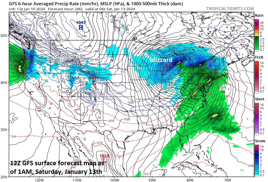
Power outages continue to affect much of the eastern seaboard today from the Carolinas-to-Maine as a result of the latest powerful storm system that is now pushing into the southeastern part of Canada. As this system exits, attention now turns upstream where low pressure is intensifying over the western states. This next system will become a powerhouse by the time we get to Friday evening centered somewhere over the Upper Midwest/Great Lakes region. In fact, this next storm is likely to generate blizzard conditions across portions of several Midwestern/Great Lakes states including Illinois, Indiana, Wisconsin and Michigan and impact such cities as Chicago, Milwaukee, Madison, and Grand Rapids. On Saturday, howling winds will continue across the Great Lakes and lake-effect snows are likely just downstream of the still largely unfrozen and relatively warm waters of Lakes Erie and Ontario.
In the storm’s warm sector, it looks like another heavy rain and strong wind event for the Mid-Atlantic/NE US centered on the Friday night time period as southeasterly winds out ahead of the surface low pressure system assure above freezing temperatures during the bulk of the storm. Given the already well saturated grounds from numerous recent heavy rain events, any additional heavy rainfall has the potential to produce another round of flash flooding on Friday night in the northeastern states.

Intense cold air is now slipping into the US from western Canada and it will feature temperatures that may be colder-than-normal by as much as 85 degrees or so (circled area upper, right). This forecast map of 2-meter temperature anomalies comes from the 06Z Euro and is valid at 10AM, Saturday, January 13th with the greatest departures from normal near the Montana/Canadian border (Map courtesy ECMWF, weathermodels.com (Dr. Ryan Maue, Twitter)
Meanwhile, intense cold has built up over the western part of Canada in recent days and it is just now slipping south and east into the US. This intense cold - partly as the result of an on-going stratospheric warming event in the northern hemisphere - will continue to push south and east over the next few days and the late week/weekend storm system will actually help out in its advance across much of the nation. As the stratosphere layer warms, it expands and, in compensation, the layer underneath called the troposphere contracts and cools. In this particular case, the stratospheric warming is centered near or over the western part of Canada and this is right about where the intense cold has developed in recent days.

The stratosphere has warmed over western Canada (left plot, indicated by arrow) in recent days and this is where some intense cold (right map, boxed in region) has developed in the troposphere layer right underneath. This intensely cold air will push to the south and east in coming days and a modified version will make its way all the to the east coast by late in the upcoming weekend. Maps courtesy NOAA, tropicaltidbits.com
It certainly is not too unusual to experience intense cold across the northern US in the middle of January; however, there are reasons to believe that this particular air mass will indeed be rather uncommon in that temperatures may be as much as 85 degrees or so below the average for this time of year. On the backside of the storm system, much colder air should make it all the way to the eastern seaboard by the second half of the weekend.

Enough cold air is likely to arrive in the Mid-Atlantic region by next Monday, January 15th to put accumulating snow on the table for the I-95 corridor if indeed a storm intensifies along the east coast. Map courtesy ECMWF, weathermodels.com
As it turns out, the influx of much colder air to the eastern US may become important as there is the threat for yet another storm system early next week that could intensify somewhere near the east coast in the Monday night/Tuesday time frame. There are still plenty of details to work out and the atmosphere has to get through the late week/weekend storm system; however, accumulating snow would likely be on the table for any early-to-mid week storm given the expected preceding influx of much colder air.
Meteorologist Paul Dorian
Arcfield
arcfieldweather.com
Follow us on Facebook, Twitter, YouTube
Video discussion: