
11:45 AM | ****Two accumulating snow events this week in the Mid-Atlantic region…second one at week’s end has a lot of potential and will be followed by an Arctic blast****
Paul Dorian

The late week system will feature very strong upper-level low over southern Canada/Great Lakes and this will spawn the development and intensification of low pressure near the east coast. This late week has a lot of potential and it can produce significant snowfall amounts in parts of the Mid-Atlantic region. Map courtesy ECMWF, Weather Bell Analytics (Joe Bastardi, Twitter)
Overview
During the past couple of years, many spots along the DC-to-Philly-to-NYC corridor have not had more than an inch of snow in any single event…that “snow drought” is about to end. In fact, there will likely be two accumulating snow events this week in the Mid-Atlantic region with the first one from later today into Tuesday likely resulting in a general 2-4 inch snowfall and there can be isolated higher amounts of 5 inches. The second accumulating snow event comes at week’s end and this one has the potential to produce significant snowfall amounts. This late week system will be followed by an Arctic blast for the upcoming weekend in the Mid-Atlantic region. Temperatures are likely to climb back to above-normal levels later next week, but Arctic outbreaks are destined to return to the central and eastern US during late January and February given the on-going stratospheric warming event over the northern hemisphere polar region.

Low pressure will intensify just off the east coast late tonight and early Tuesday and the result is likely to be a general 2-4 inches snowfall in the DC-to-Philly-to-NYC corridor - the highest in a couple of years in some spots - and there can be isolated higher amounts of 5 inches. Map courtesy NOAA, tropicaltidbits.com
Monday/Tuesday accumulating snow
Many places along the Mid-Atlantic’s I-95 corridor have not had more than an inch of snow in a single event since the second half of the winter in early 2022, but that “snow drought” should shortly come to an end. Snow developed across the DC and Baltimore metro regions late last night and early this morning associated with a “forerunner” upper-level jet streak with a coating to an ½ inch or so.

Low pressure just off the east coast will intensify rather rapidly late tonight and early Tuesday and there will be strong “frontogenesis” by mid-day tomorrow leading to the chance for some heavier snow bands in the Mid-Atlantic region. Map courtesy NOAA, tropicaltidbits.com
The main action, however, with this unfolding system will take place from later today into later Tuesday and a general 2-4 inch snowfall is likely in the DC-to-Philly-to-NYC corridor with isolated higher amounts of 5 inches. The snow will be of the light and fluffy variety given the very dry (e.g., dew point of 3 degrees near Philly at mid-day) and cold air that infiltrated the Mid-Atlantic region on Sunday following the passage of an Arctic front that featured strong winds and snow shower/squall activity. The low pressure system will intensify rather rapidly late tonight and early Tuesday just off the east coast and strong “frontogenesis” can lead to the formation of heavier snow bands in the Mid-Atlantic region on Tuesday.

Low pressure will intensify near the east coast on Friday and this system has the potential to produce significant snowfall amounts in the Mid-Atlantic region. There will be a direct discharge of Arctic air on its heels from eastern Canada into the Mid-Atlantic region during the upcoming weekend. Map courtesy NOAA, tropicaltidbits.com
Accumulating snow event at week’s end
High pressure will take control of the weather at mid-week and then attention will turn to an impressive upper-level low that will rotate through southern Canada and over the Great Lakes region. This upper-level system represents a piece of the polar vortex that has recently split up as a result of an on-going stratospheric warming event. The strong upper-level low will help to spawn the formation of low pressure along the east coast by Friday and this next system is likely to produce another round of accumulating snow for the Mid-Atlantic region at the end of the week. There is a lot of potential with this system, in my opinion, with significant snow accumulations on the table in the Mid-Atlantic region…something we’ll keep our eyes on in coming days.

The late week storm system will usher in another Arctic air mass for the Mid-Atlantic region for the upcoming weekend likely leading to single digits lows in many areas. Map courtesy NOAA, Pivotal Weather
Arctic blast for the upcoming weekend
In the wake of the late week storm, there will be a direct discharge of Arctic air from eastern Canada into the Mid-Atlantic region and Northeast US. This Arctic air outbreak is quite likely to result in single digit lows by Sunday and Monday mornings in much of the northeastern part of the nation - aided in part by snow cover that should become widespread by the weekend. The Arctic air mass will remain in control into Monday of next week, but there will be warmup later next week across much of the central and eastern US that will bring temperatures back to above-normal levels.
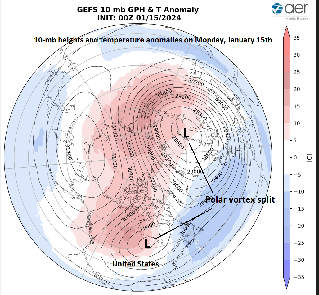
The polar vortex has split into two in recent days and this on-going stratospheric warming event over the polar region of the northern hemisphere enhances the chance for additional Arctic air outbreaks in the central and eastern states during late January and February. Map courtesy NOAA, AER (Dr. Judah Cohen, Twitter)
On-going stratospheric warming
The likely warmup next week should only be a temporary event as an on-going stratospheric warming event in the polar region of the northern hemisphere enhances the chance for additional cold air outbreaks during late January and February across the central and eastern US. The polar vortex has split into two vortex centers during just the past couple of days and this is the second time this “split” has occurred during the last couple of weeks. The impact of stratospheric warming in the northern hemisphere’s polar region can take up to several weeks before it impacts temperature patterns across the central and eastern US; hence, likely cold air outbreaks coming during the month of February.
Meteorologist Paul Dorian
Arcfield
arcfieldweather.com
Follow us on Facebook, Twitter, YouTube
Video discussion: