
1:00 PM | ***Dense fog, wet and mild in the Mid-Atlantic with a surge in temperatures on Friday…rain-to-snow scenario interior on Sunday night…wet MS/TN Valleys and west coast***
Paul Dorian

Plenty of rain is coming to the Lower Mississippi and Tennessee Valleys in coming days - alleviating recent drought conditions - and there will be plenty of moisture headed to the US west coast during the next couple of weeks. Map courtesy Canadian Met Centre, tropicaltidbits.com
Overview
The next couple of days will be wet, foggy and mild in the Mid-Atlantic region and there will be a surge of temperatures on Friday in much of the I-95 corridor. Another storm system is then going to impact the Mid-Atlantic late in the weekend with one surface low pressure system (primary) heading into the Ohio Valley and a secondary likely to form near the Mid-Atlantic coastline. While there will be little cold air around initially, strong high pressure will build into southeastern Canada and act as a cold air source. This is likely to result in a changeover from rain-to-snow across much of the interior, higher elevation Mid-Atlantic region on Sunday night and there is a chance for a changeover to snow all the way down into the N/W suburbs of the big cities.
Elsewhere, the overall pattern for the next several days will bring copious amounts of rainfall to the Lower Mississippi and Tennessee Valleys - areas that have been quite dry in recent weeks - and to the US west coast from California-to-Washington which will be inundated by multiple storms during the next couple of weeks.
Wet, dense fog, and mild in the Mid-Atlantic region
The next couple of days will feature mild conditions in the Mid-Atlantic, occasional rain and drizzle, and widespread dense fog resulting from the mild air moving over the now diminishing snowpack. This type of fog is known as an advection fog and occurs when moist, mild air passes over a colder surface such as snow and is cooled from underneath down to its dew point (i.e., 100% relative humidity). On Friday, it’ll turn even warmer and the rain may wind down early in the day allowing for skies to brighten during the afternoon hours. And as a final blow to any remaining stubborn snow piles, temperatures will surge to end the work week in metro areas like DC and Philly where highs could reach 65 degrees and 60 degrees respectively. The surge of warmth on Friday may not quite make it all the way north into the NYC metro area as that region is likely to stay on the cool side of a frontal system.
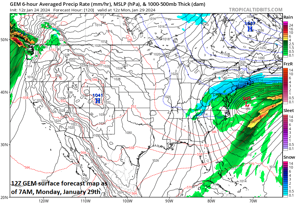
Enough cold air could get wrapped into a late weekend storm system near the Mid-Atlantic coastline for a changeover from rain-to-snow in many interior higher elevation sections and there is a chance for a changeover to snow into the N/W suburbs of the big cities. Map courtesy Canadian Met Centre, tropicaltidbits.com.
Rain-to-snow scenario late this weekend across the interior Mid-Atlantic
The weekend does begin on the mild side in the Mid-Atlantic region, but it turns colder by the second half. A storm system will impact the Mid-Atlantic region on Sunday and Sunday night with a (primary) low pressure system heading into the Ohio Valley and a secondary forming just off the Mid-Atlantic coastline. This secondary low just off the Mid-Atlantic coastline becomes the main player by the time we get to late Sunday night/early Monday morning. While there will be little in the way of true cold air around initially, a developing strong high pressure system across southeastern Canada could eventually help to provide enough cold air for a changeover from rain-to-snow across interior higher elevation sections of the Mid-Atlantic and possibly, down into the N/W suburbs of the big cities. A cold air mass will follow for the early part of next week in the Mid-Atlantic region, but it turns milder again later next week.

The “rain-to-snow” scenario in the interior Mid-Atlantic region is shown by the 12Z Canadian forecast model (above) and also the 12Z Euro as shown here for 1AM, Monday. Map courtesy ECMWF, Pivotal Weather
Very wet period for Lower Mississippi and Tennessee Valleys and also the west coast
This unfolding pattern of moisture flowing northeastward from the Gulf of Mexico into the eastern US will result in copious amounts of rainfall for the Lower Mississippi and Tennessee Valleys during the next few days. In fact, several inches of rain are possible in these areas that have been experiencing drought conditions over the past few months.

The Lower Mississippi and Tennessee Valleys have experienced drought conditions in recent weeks…that will change significantly with this week’s soaking. Map courtesy NOAA/CPC
The next couple of weeks will also likely be very wet for the US and Canadian west coasts with multiple storm systems on the way for California, Oregon, Washington and British Columbia (Canada). A powerful west-to-east jet stream across the Pacific Ocean will no doubt bring the phrase “atmospheric river” back to the forefront many times in coming days…low-lying areas out west will get plenty of rainfall and higher elevation locations will get lots of snowfall (e.g., Sierra Nevada).
Meteorologist Paul Dorian
Arcfield
arcfieldweather.com