
10:45 AM | ****Heavy rain, potentially damaging winds in the Mid-Atlantic/NE US from Tuesday into Wednesday…second powerhouse storm system at week’s end and a Midwest blizzard...some intense cold****
Paul Dorian

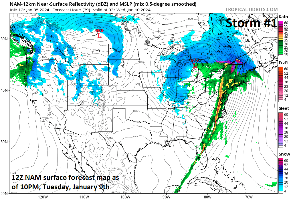
Strong and potentially damaging winds - aided by a powerful low-level jet streak - will accompany the initial powerhouse storm system this week raising the chance for numerous power outages from later tomorrow into Wednesday across the Mid-Atlantic region and Northeast US. Map courtesy NOAA, tropicaltidbits.com
Overview
A very active weather pattern will continue this week with two powerhouse storm systems to deal with across much of the nation. The initial storm system will produce lots of snowfall from today into Tuesday in a zone from the central Plains to the Midwest. This same system will produce heavy rain on Tuesday afternoon and Tuesday night in the Mid-Atlantic region and Northeast US with significant flooding on the table. In addition, strong and potentially damaging winds will accompany this first storm system raising the chance of power outages from later tomorrow into Wednesday across the northeastern states.
By the end of the week, another powerful storm system will be taking shape and this one will have more in the way of Arctic air to work with and a blizzard is likely across much of the Midwest with additional heavy rainfall and strong winds destined for the eastern seaboard. The passage of the weekend storm will usher in much colder air for the Mid-Atlantic and Northeast US and signs continue to point to some intense cold possibly moving into the central and eastern US by early next week. In addition, attention will turn to the possibility of yet another storm system to deal with in the eastern states during the early or middle part of next week.
Heavy rain is destined for the Mid-Atlantic/Northeast US on Tuesday afternoon and Tuesday night and there can be a line of thunderstorms mixed into the picture aligned from north-to-south. Snow (shown in blue) will likely bring accumulations to portions of the Midwest and interior New England as well. Map courtesy NOAA, tropicaltidbits.com
Initial powerful storm system
Low pressure will pull out of the central Plains later today and intensify substantially on its way to the Midwest by later tomorrow. Snow will spread from the central Plains today to the Midwest/northern Mississippi Valley region on Tuesday and rain will push northeastward into the Mid-Atlantic/NE US. By tomorrow afternoon, the rain will become heavy in the DC-to-Philly-to-NYC corridor and it’ll continue heavy at times into tomorrow night with a few inches possible. Given the already well saturated grounds from multiple recent heavy rain events, the risk for significant flooding will be high in the Mid-Atlantic/NE US. In addition, a big factor during this storm will be the winds which will become quite strong and potentially damaging raising the prospects of power outages in many parts of the eastern US. On the front side of the storm, winds can gust past 50 mph or so from an east-to-southeast direction in the Mid-Atlantic/NE US and then on the back side on Wednesday, winds can gust past 40 mph from a west-to-southwest direction. Given the very wet grounds throughout the northeastern states, these strong winds may knock down some tree limbs and even fully-grown trees may be vulnerable with the soaked grounds and possibly weakened root systems.
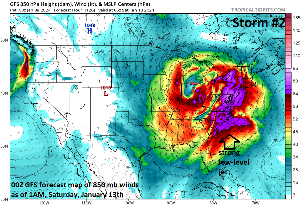
Strong and potentially damaging winds - aided by a powerful low-level jet streak - will accompany the second powerhouse storm system late this week/weekend raising the chance again for power outages across much of the northeastern quadrant of the nation. Map courtesy NOAA, tropicaltidbits.com
Second powerhouse storm system at week’s end/weekend
Another powerhouse storm system will impact a wide part of the nation at week’s end and into the upcoming weekend. In fact, this second system may meet the qualifications of a “bomb cyclone” - rare over land - which is defined as having its central pressure drop by at least 24 millibars in a 24-hour period. Some computer forecast model runs have the lowest pressure of this storm bottoming out as low as 962 millibars which is 28.41 inches and quite rare for this part of the world.
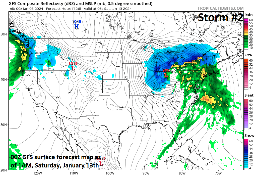
An all-out blizzard is possible at the end of the week/upcoming weekend across much of the Midwest and blizzard conditions may extend to throughout the Great Lakes region as well. In the warm sector, more heavy rainfall is destined for the eastern states and, once again, winds are likely to be quite strong with damage to trees and limbs on the table. Map courtesy NOAA, tropicaltidbits.com
This second storm system will have more in the way of Arctic air to work with and the result may be an all-out blizzard for sections of the Midwest including such states as Michigan, Illinois and Indiana. In the east, mild air will again surge northward out ahead of the surface low over the Midwest leading to the possibility of more flooding rainfall and, once again, winds will be strong and potentially damaging from the Midwest/Great Lakes to the Mid-Atlantic/Northeast US. The passage of the weekend storm system will usher in colder air for the Mid-Atlantic/Northeast US and there could be another (third) storm system to deal with in the eastern states during the first half of next week….more on that later this week.

Extreme cold has generally been confined to the Siberian side of the North Pole, but there are strong signs for an influx into North America with this forecast map of 2-meter temperatures as much as 50 degrees below-normal by Tuesday of next week. Map courtesy NOAA, weathermodels.com (Dr. Ryan Maue, Twitter)
Intense cold
One final note of interest, a stratospheric warming event that began in November has contributed to the unleashing of some brutally cold air masses into the middle and high latitudes from the polar region. A few weeks ago, China recorded its lowest temperatures in many decades and just in the last week, Scandinavian countries of Sweden, Denmark and Finland have seen some of their coldest temperatures since last century.
There continue to be strong signs that intense cold air will make its way onto the North America side of the North Pole later this week and into the weekend. In fact, recent forecast model runs show some intense cold air reaching the middle Mississippi and Tennessee Valleys in about a week’s time with temperatures some 50 degrees below-normal for this time of year.
Buckle up…lots of action in the weather department during the next week to ten days.
Meteorologist Paul Dorian
Arcfield
arcfieldweather.com
Follow us on Facebook, Twitter, YouTube
Video discussion: