
10:30 AM (Thursday) | ***Storms cleanse the atmosphere of the high heat and humidity...at least for a few days...heat returns in full force for Sunday through Wednesday time period***
Paul Dorian

The time period from Sunday through Wednesday of next week looks very hot in the Mid-Atlantic region with the upper 90’s certainly on the table for afternoon highs…and there can be some record-breaking high temperatures in this stretch. Map courtesy Weather Bell Analytics, ECMWF
Overview
Powerful storms rocked the Mid-Atlantic and Northeast US late yesterday and last night and cleansed the atmosphere of the high heat and humidity…at least for a few days. One of the ingredients involved with yesterday’s unstable atmosphere was a cold frontal system that has edged off the east coast On Thursday morning; however, we are not done yet with this system. That cold front will stall out later today right along the east coast and copious amounts of tropical moisture will ride up along its boundary zone from tomorrow into Saturday leading to additional showers and thunderstorms around here and some of the rain will be heavy. The high heat of recent days has backed off for the next few days, but it will return in full force in the Mid-Atlantic region for the Sunday, Monday, Tuesday, Wednesday time period and 100 degree highs are on the table.
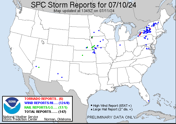
Six tornadoes have been confirmed across New York State from yesterday’s storms and there have been multiple wind damage reports as well across the Mid-Atlantic/NE US. Map courtesy NOAA/SPC
Details
Powerful thunderstorms hit much of the interior Mid-Atlantic and Northeast US late yesterday and last night with many reports of wind damage and six tornadoes have now been confirmed in New York State. The combination of a cold front, high heat, and copious amounts of tropical moisture led to the very unstable conditions in the atmosphere and the late day and nighttime thunderstorms. The frontal system edged off the east coast earlier today and there is a noticeable improvement in the air mass with lower temperatures and also lower overall humidity amounts. The front will stall along the coast later today and lots of tropical moisture will ride up along the frontal boundary zone from tomorrow into Saturday. After a largely rain-free day today in the Mid-Atlantic region, the threat of showers and thunderstorms will increase markedly on Friday and continue right into Saturday…some of the rain that falls will be heavy at times.

There was some beneficial rainfall last night in the Mid-Atlantic/NE US and more is on the way. Showers and thunderstorms are likely on Friday, Friday night, and Saturday and some of this rain will be heavy at times with a couple of inches possible; especially, across Delaware and Southern New Jersey. Map courtesy Weather Bell Analytics, ECMWF
In terms of temperatures, the passage of the cold front – even to a nearby position just off the coast – has allowed for a noticeable reduction of the high heat of recent days. Highs on Wednesday were commonly well up in the 90’s along the DC-to-Philly-to-NYC corridor, but should be confined to the upper 80’s today and then the lower 80’s on Friday when there will be plenty of cloud cover. Dew point temperatures have also dropped noticeably on the heels of the frontal passage from the 70’s on Wednesday to the 60’s on Thursday, but overall moisture will become higher again on Friday and the threat of rain will increase.
After a lingering chance of showers and thunderstorms on Saturday - some of which can be heavy - the latter part of the upcoming weekend will generally feature rain-free conditions as the “coastal” moisture finally exits to the east. As a result, Sunday should feature plenty of sunshine and with an intensifying upper-level ridge, temperatures are likely to soar well up into the 90’s all along the I-95 corridor. The hot weather will continue on Monday, Tuesday, and Wednesday and record highs could very well be challenged with the mid-to-upper 90’s likely for afternoon highs…indeed, triple digit high temperatures can be reached in a few spots.

While the Sunday through Wednesday time period of next week looks to be very hot in the Mid-Atlantic region, there is already some relief in sight. A cooler-than-normal air mass will drop southeastward from Canada into the northern US by the middle of next week and it likely reaches the Mid-Atlantic region in about a week’s time. Map courtesy NOAA, tropicaltidbits.com
There is light at the end of the tunnel, however, with respect to next week’s expected heat wave. While the Sunday through Wednesday time period looks very hot, a cooler air mass should drop southeastward by the middle of next week from Canada into the Northern US. After a likely mid-week frontal passage, it should turn cooler around here by around Thursday of next week and this will be quite welcome after what is expected to take place during the first half of the week. There are even some signs that suggest the remainder of July might turn out to be rather reasonable temperature-wise across the Mid-Atlantic…we’ll wait a bit to confirm that possibility.
Meteorologist Paul Dorian
Arcfield
arcfieldweather.com
Follow us on Facebook, Twitter, YouTube
Video discussion: