
12:45 PM | ***TS Debby strengthens off SC coast with 60 mph winds...makes second landfall early Thursday...to turn north and impact Mid-Atlantic region from late Thursday through Friday night***
Paul Dorian

Tropical Storm Debby sits just off the coast of South Carolina at mid-day on Wednesday and has strengthened some with maximum sustained winds increasing from 45 mph at 8AM to 60 mph at 11 AM. Images courtesy NOAA/STAR (GOES-East)
Overview
Tropical Storm Debby is out over the very warm waters of the southwestern Atlantic Ocean and it has strengthened some today with maximum sustained winds now at 60 mph. Tropical Storm Debby will make a second landfall by early tomorrow morning and then begin a turn to the north that should bring it’s remnants just to the west of the Mid-Atlantic’s I-95 corridor on Friday afternoon. As such, there is the threat of some heavy rainfall, strong thunderstorms, gusty winds in the Mid-Atlantic region from late Thursday through Friday night and isolated tornadoes are on the table. The tropical system will accelerate to the northeast by Saturday with improving conditions in the Mid-Atlantic region and we’re setting up for a stretch of nice weather from Sunday through Tuesday all across the northeastern part of the nation.

Heavy rain fell in much of the Mid-Atlantic region last night, but this was just a “forerunner” event. Another heavy rain event is on the was as the remains of Tropical Storm Debby pass by on Friday likely bringing 2-4 inches of rain to much of the Mid-Atlantic and isolated higher amounts are possible. Map courtesy NOAA/WPC, Mark Margavage (X)
Details
Tropical Storm Debby has been meandering off the coast of South Carolina today over some very warm waters of the southwestern Atlantic Ocean. It has indeed undergone strengthening with maximum sustained winds increasing from 45 mph at 8AM to 60 mph at 11AM. Tropical Storm Debby is likely to make a second landfall very late tonight or early Thursday morning along the central coastline of South Carolina. Rainfall amounts have been excessive in parts of the Southeast US from this tropical system with expected final amounts as high as 25 inches in South Carolina, and 15 inches in portions of North Carolina and Georgia.
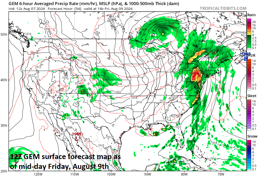
The center of the remnants of Tropical Storm Debby will likely slide just to the west of the Mid-Atlantic’s I-95 corridor on Friday in a general south-to-north direction. The result in the Mid-Atlantic region will be some heavy rainfall, strong thunderstorms, gusty winds, and even isolate tornadoes are on the table from late Thursday through Friday night. Map courtesy Canadian Met Centre, tropicaltidbits.com
Later tomorrow, a turn to the north of the tropical storm will begin bringing the remnants into the Mid-Atlantic region on Friday and likely passing just to the west of the I-95 corridor. As a result, there is the threat for some heavy rainfall, strong thunderstorms, and gusty winds from late Thursday through Friday night in the Mid-Atlantic region. In addition, isolated tornadoes are on the table in the I-95 corridor as is somewhat typical in areas on the right side of the storm track with an accelerating northward-moving tropical system. Also typical of a tropical system when it reaches higher latitudes, this remnants of Debby will accelerate likely reaching New England on Saturday and then the Canadian Maritime Provinces by later Sunday.

A beautiful air mass is headed to the Great Lakes, Midwest, Mid-Atlantic, and Northeast US for the Sunday through Tuesday time period of next week with comfortable temperatures and humidity levels. Map courtesy Canadian Met Centre, tropicaltidbits.com
On the heels of the tropical system, weather conditions will improve on Saturday morning in the Mid-Atlantic region and the day should turn out to be mainly sunny in places like Philly and Washington, D.C. Beyond that, a stretch of very nice weather is coming to the Great Lakes/Midwest/Mid-Atlantic/Northeast US from Sunday through Tuesday of next week with very comfortable temperatures and humidity levels as we head towards the middle of August.
Meteorologist Paul Dorian
Arcfield
arcfieldweather.com
Follow us on Facebook, Twitter, YouTube
Video discussion: