
11:30 AM | *Atlantic Basin showing some life after quietest stretch with no newly named storms since 1968...cool, crisp air mass from Great Lakes to Northeast US with a few early day record breakers*
Paul Dorian

September has begun and there are now three tropical waves to monitor in coming days. From a climatological viewpoint, the peak of the Atlantic Basin tropical season falls on right around the 10th of the month. Map courtesy NOAA/NHC
Overview
The month of September is now underway and there are three tropical waves to monitor in the Atlantic Basin in coming days, but none of these has yet to attain named tropical storm status. In fact, there has not been a newly named tropical storm system in the Atlantic Basin since “Ernesto” formed back on August 12th. The time period from the 13th of August until today, September 3rd, is the first such quiet stretch since 1968 without a newly named tropical system.
At the same time the tropics are showing some life after a quiet stretch here in early September, cool, crisp and dry air is dominating the scene from the Great Lakes/Upper Midwest to the Mid-Atlantic/Northeast US. Numerous locations early this morning were quite close to their record low temperatures for the date and indeed, there were a few spots that actually set daily low temperature records.

Sea surface temperatures have been running at well above-normal levels in the Atlantic Basin which is usually favorable for tropical activity; however, it is only one of several factors that can have an influence on tropical storm formation and intensification. For example, the influx of Sahara Desert dust air can play a role in tropical activity in the Atlantic Basin as can North Atlantic sea surface temperatures, and even solar activity has been observed as playing a role. Map courtesy NOAA, weathermodels.com
Tropical scene
“Ernesto” became a named tropical storm on August 12th as it neared the Leeward Islands and ultimately, it reached hurricane status out over the warm waters of the western Atlantic. Since “Ernesto”, there has not been a newly named tropical storm system in the Atlantic Basin and the stretch of time from August 13th until today, September 3rd, without a newly named tropical storm hasn’t happened since 1968 (credit Dr. Philip Klotzbach, X). We have now reached the beginning of the month of September which is climatologically speaking when the Atlantic Basin tropical season reaches a peak. Indeed, the tropics are showing some life in the Atlantic with three different tropical waves to monitor in coming days...none of these has yet to climb to named tropical storm status and there is no guarantee that they any of them will.
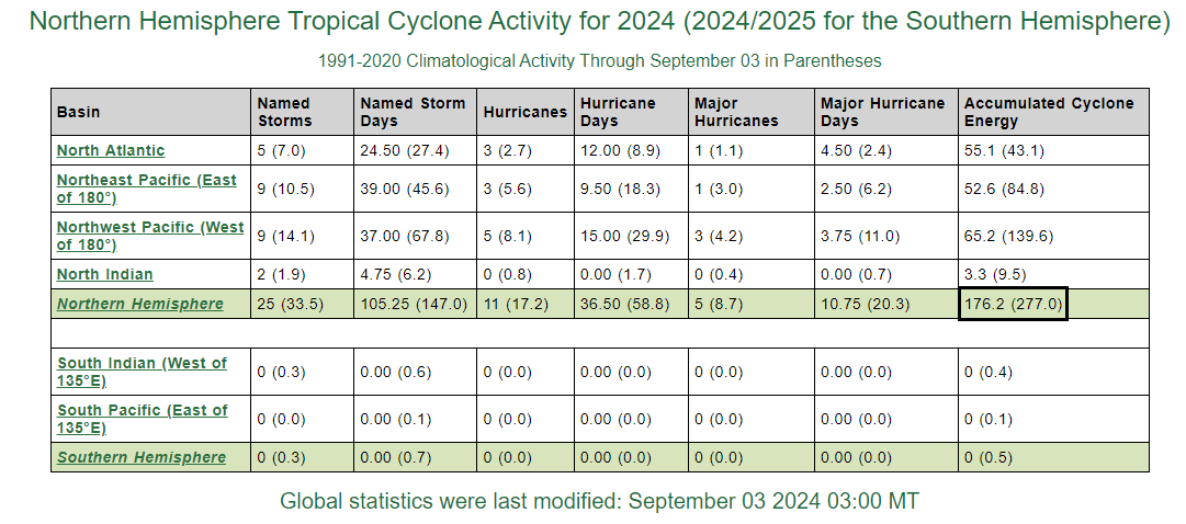
Tropical activity for the Northern Hemisphere is running at below-normal levels in terms of the accumulated cyclone energy (ACE, right boxed in region). Data courtesy Colorado State University
Overall, for the 2024 tropical season, and despite this recent quiet stretch, the Atlantic Basin still remains at above-normal levels in terms of accumulated cyclone energy (ACE) due to an active early season. (The ACE is an excellent metric used by meteorologists to assess overall tropical activity as it factors in both magnitude and longevity of tropical systems). The northern hemisphere as a whole is running at below-normal levels with respect to ACE thanks in large part to a quieter-than-normal Pacific Ocean that has taken place so far on both sides of the International Date Line (180°).

Very cool conditions early today across the Great Lakes, Midwest, Mid-Atlantic and Northeast US and there were even a few record breakers for the date. Map courtesy coolwx.com, NOAA
Cool, crisp, dry air mass from the Great Lakes to the Northeast US
Meanwhile, as the tropical scene in the Atlantic Basin shows some life here at the beginning of September, a cool, crisp, and dry air mass has encompassed the region from the Great Lakes/Upper Midwest to the Mid-Atlantic/Northeast US during the past couple of days. Temperatures have been below-normal for early September and should stay at pleasant levels for another couple of days with the backing of a strong Canadian-born high pressure system that is currently over the northeastern states. The temperatures early today dropped to near record lows over many locations in the Midwest, Mid-Atlantic, and Northeast US and a few daily low temperature records were actually broken in this unusually cool outbreak for early September (e.g., State College, PA at 45 degrees, Saranac Lake, NY at 31 degrees).
Looking ahead, relatively comfortable temperatures should continue through the late week/early weekend across the northeastern states, but the rain-free conditions may come to an end as an incoming cold front from the northwest combines with low pressure moving up along the Atlantic seaboard in the Friday night-to-Saturday night time period. On the heels of a late weekend frontal passage, more cool and dry air will push back into the Great Lakes, Upper Midwest, Mid-Atlantic and Northeast US for the early part of next week.
Meteorologist Paul Dorian
Arcfield
arcfieldweather.com
Follow us on Facebook, Twitter, YouTube
Video discussion: