****A couple of snow events in the Mid-Atlantic…a burst of snow later Friday…an important snow threat for late Sunday night and Monday with several inches on the table****
Paul Dorian
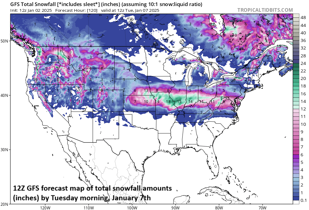
A west-to-east moving strong storm system will produce significant snowfall amounts later this weekend and early next week from the central Plains to the Mid-Atlantic region. Immediately to the south of the accumulating snow zone, there will be a highly impactful swath of ice all along the way. Map courtesy NOAA, tropicaltidbits.com
Overview
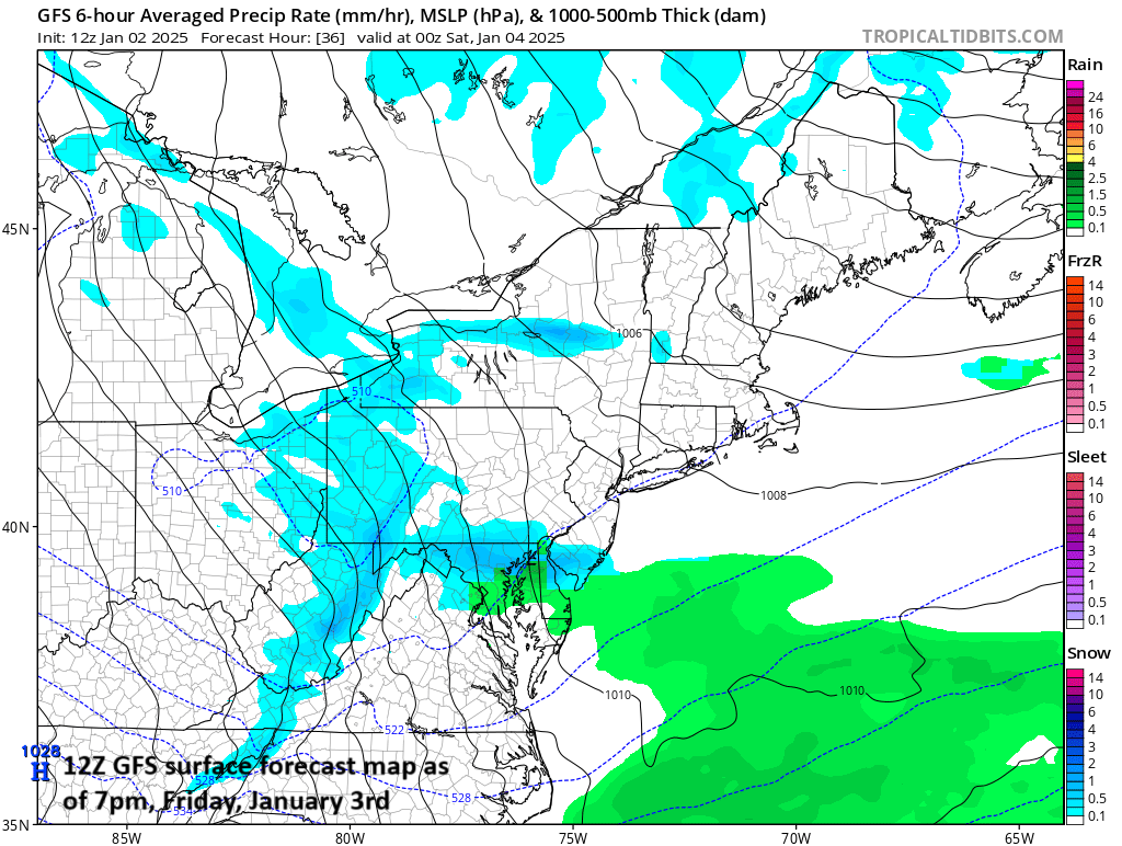
A colder and active weather pattern is indeed unfolding for the central and eastern US and it is likely to bring two threats of snow to the Mid-Atlantic region during the next several days. First, an upper-level wave will rotate around the base of a large-scale trough of low pressure later tomorrow and it can produce snow showers in the area and maybe even a period of steadier snow; primarily, in the region from DC/Delmarva-to-southeastern PA/southern NJ…some accumulations are on the table of a coating to an inch or so in DC and as much as 2 or 3 inches in the Philly/northern Delmarva/southern NJ area.
A surge of Arctic air will then follow the system later tomorrow night setting us up for a cold weekend in the Mid-Atlantic region. A more important threat of snow comes for late Sunday night and Monday as low pressure moves eastward from the Midwest with significant accumulations on the table in portions of the Mid-Atlantic region including the DC-to-Philly corridor.
While a more important snow threat exists for late Sunday night and Monday in the Mid-Atlantic region, a system arriving late tomorrow should not be discounted. There are likely to be snow showers in the southern Mid-Atlantic region later tomorrow and perhaps even a period of steadier snow. Some accumulations are on the table with a coating to an inch or so possible in the DC metro and as much as 2 or 3 inches possible across SE PA, northern Delmarva, and southern New Jersey. Map courtesy NOAA, tropicaltidbits.com
Threat of snow/snow showers late Friday/early Friday night
It turns colder today and tomorrow in the Mid-Atlantic region and then another step-down in temperatures will take place this weekend as Arctic air moves in on the heels of a cold frontal system. This cold front will push into the area later tomorrow and early tomorrow night and it will have some support aloft as a short-wave of energy rotates through the base of a large-scale upper-level trough of low pressure. As such, there will be enough lifting in the atmosphere to produce some snow shower activity and perhaps even a period of steadier snow. Some accumulations are possible later tomorrow and early tomorrow night; primarily, in the region from DC-to-the-Delmarva-to-southeastern PA-to-southern New Jersey with a coating to an inch or so in the DC metro, and as much as 2 or 3 inches in the Philly/northern Delmarva/southern NJ area. This system pushes east of here late tomorrow night and an Arctic air mass will follow for the weekend.
Low pressure will move from west-to-east this weekend and early next week from the central Plains to the Mid-Atlantic region. Snow should move into the Mid-Atlantic region late Sunday night and continue on Monday with significant accumulations on the table in, for example, the DC-to-Philly corridor. Map courtesy NOAA, tropicaltidbits.com
Threat of significant accumulating snow late Sunday night and Monday
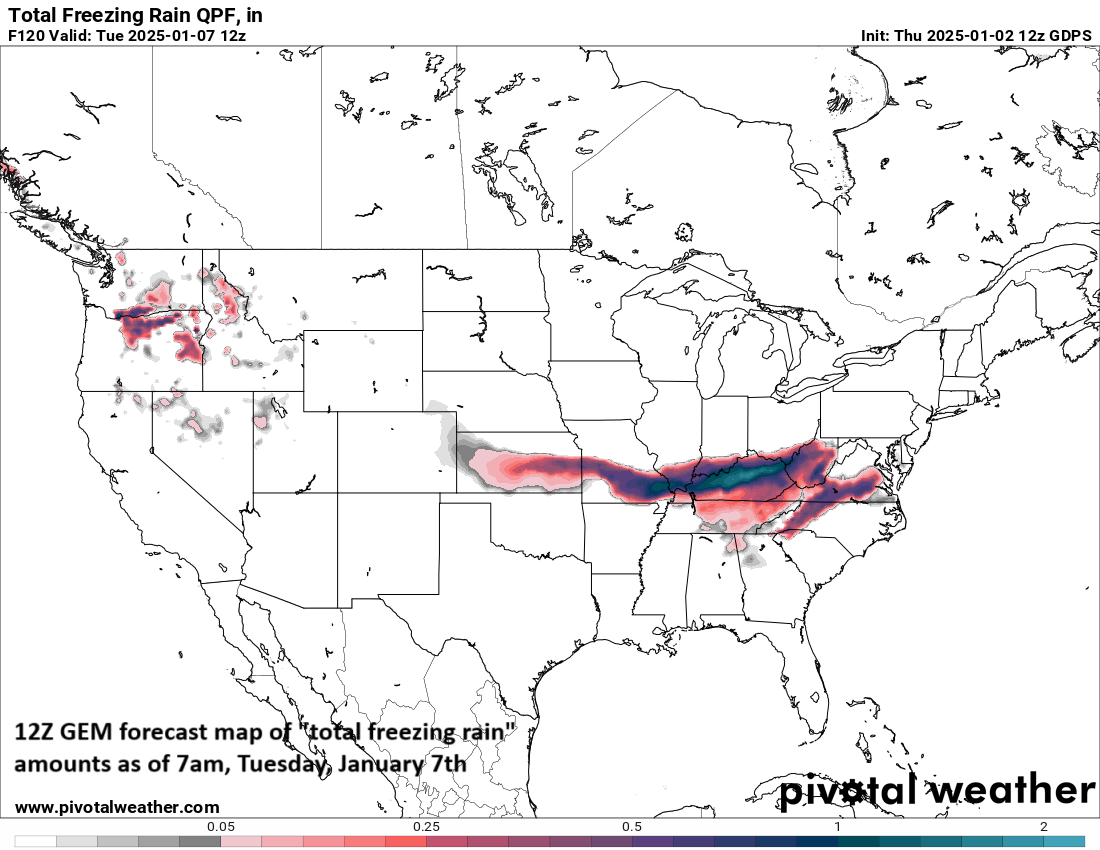
By the latter part of the weekend, low pressure will intensify over the middle of the nation and it’ll have quite a bit of cold air to work with resulting in plenty of accumulating snow on its north side. This system will move from west-to-east producing a significant snowfall late in the weekend across much of the Midwest. In addition, there will be a swath of highly impactful ice associated with this storm system as it treks east from the central Plains to the Mid-Atlantic region.
The storm system that will impact a wide part of the nation this weekend and early next week will produce a long swath of highly impactful ice as it treks eastward from the central Plains to the Mid-Atlantic region. Map courtesy Canadian Met Centre, Pivotal Weather
There is a good chance for accumulating snow to make its way into the Mid-Atlantic by late Sunday night or early Monday morning with plenty of cold air well established in the region. In fact, significant snowfall amounts are on the table for Monday in at least portions of the Mid-Atlantic region with the most probable zone for this in the I-95 corridor extending from the DC metro region to southeastern PA. As it stands now, the NYC metro region is somewhat less likely to get this kind of significant snow accumulation; however, the threat up there can still increase with days to go before the event. One other note, some sleet and/or freezing rain can mix into the picture on Monday complicating the snowfall accumulation estimates; especially, from the southern half of the DC metro to the Delmarva Peninsula to southern New Jersey.
Arctic air will follow this system with a wide part of the nation next week experiencing some bitter cold (aided by fresh snow cover in many areas) as our long anticipated major pattern change takes firm control.
Get ready…January is looking like a wild month.
Meteorologist Paul Dorian
Arcfield
arcfieldweather.com
Follow us on Facebook, Twitter, YouTube


