
**Coastal storm to bring a prolonged period of onshore flow to the Mid-Atlantic…potentially leading to significant coastal flooding/beach erosion…limited rainfall amounts to inland locations**
Paul Dorian

Prolonged onshore flow (i.e., east-to-northeast winds) will enhance the threat of significant coastal flooding/beach erosion from Long Island southward to New Jersey and the Delmarva Peninsula. Map courtesy NOAA, tropicaltidbits.com
Overview
Lots of players are on the field as we begin the weekend with one upper-level low over the Great Lakes that is dropping slowly to the southeast and a second wave of energy in the southern stream that is helping to spin up a surface low pressure system off the southeast US coast. In addition, there is a strong high-pressure system to our north that continues to shift slowly offshore as we begin the weekend. The combination of the high to the north and low to the south is already producing an onshore flow of air in the Mid-Atlantic region and this will persist for the next few days potentially leading to significant coastal flooding/beach erosion from Long Island-to-New Jersey-to-the Delmarva Peninsula. While there can be some heavy showers and strong wind gusts across inland areas during the next few days, rainfall amounts will be much more limited with the worst impact from this developing storm system confined to coastal sections.
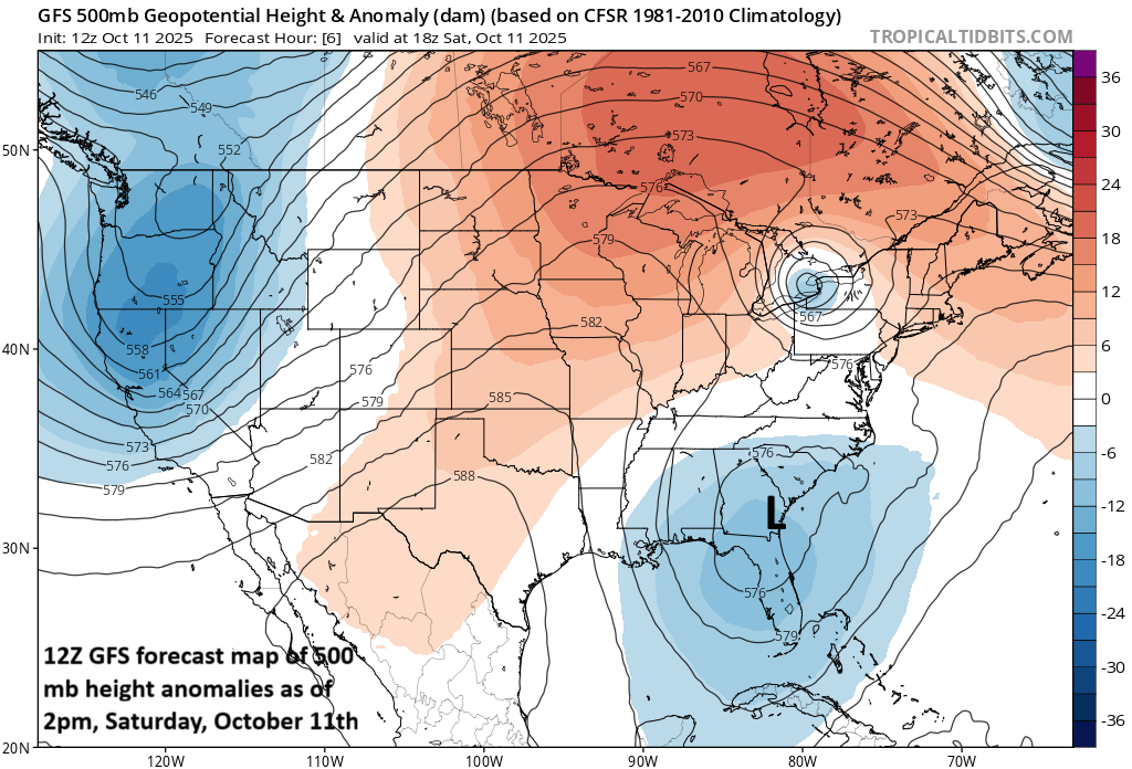
Two separate areas of low pressure aloft - one over the SE US coastline and one over the eastern Great Lakes - are key players in this upcoming event. Map courtesy NOAA, tropicaltidbits.com
Details
A strong low-pressure system now forming along the SE US coastline - supported by a sharp upper-level trough extending from the Ohio Valley to the eastern Gulf - will move slowly up along the Atlantic seaboard. With the strong high pressure positioned off the NE US coastline, the pressure gradient will tighten across the Mid-Atlantic region especially from later tonight into Sunday. An east-to-northeast flow will take hold and intensify and persist for a prolonged period potentially leading to significant coastal flooding and beach erosion from Long Island southward to the Delmarva Peninsula. The highest wind gusts during this extended event will likely be along the coastal sections of the Mid-Atlantic with 40-50 mph on the table from Long Island to eastern NJ to the coast of the Delmarva Peninsula, and inland areas (e.g., Philly, DC metros) should experience wind gusts in the 20-40 mph range.
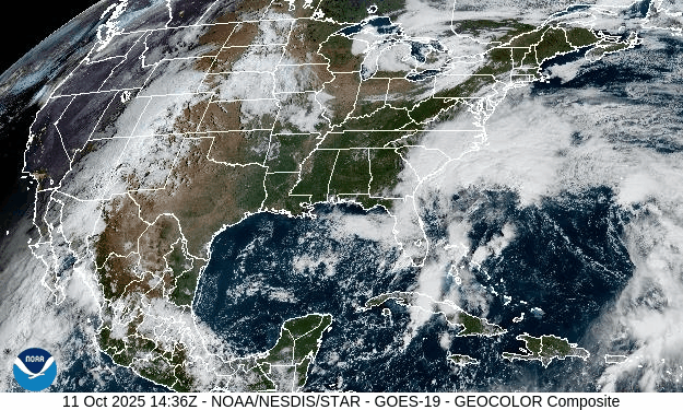
Surface low pressure is intensifying today near the SE US coastline with support aloft from a strong trough of low pressure. Images courtesy NOAA (GOES-East)
In terms of rainfall, highest amounts are likely along coastal sections with a few inches possible by the time the storm system winds down early next week in places like coastal NJ and Long Island. For inland areas along, for example, the corridor from DC to western NJ and including the Philly metro, it appears that rainfall amounts will be much more limited…maybe in the half inch to one inch range. This big differences expected between coastal sections and inland locations is the result of the gradual phasing of the two upper-level troughs of low pressure which looks like it will take a two or three day period. As such, there could be two surface lows for quite awhile instead of one consolidated storm, and that will limit rainfall amounts across inland locations in the Mid-Atlantic region…something we’ll continue to monitor.
Meteorologist Paul Dorian
Arcfield
arcfieldweather.com