
**Winter storm headed to the Mid-Atlantic/Northeast US on Tuesday with biggest impact across interior sections...snow, ice, rain mix in the I-95 corridor...little or no accumulations**
Paul Dorian

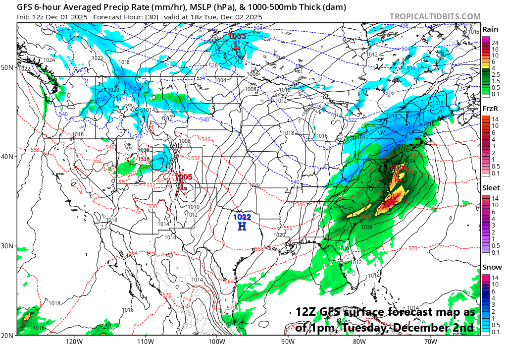
The best chance for significant snow on Tuesday (4-8 inches) will be across interior sections of the Mid-Atlantic and Northeast US…any snow or ice accumulation in the immediate I-95 corridor will be quite limited. Map courtesy NOAA, tropicaltidbits.com
Overview
December has begun on a cold note across the northeastern states and below-normal temperatures are likely on average through at least the first half of the month. Two factors that have been pointing us to an extended cold stretch this month include an unusually early stratospheric warming event over the polar region of the Northern Hemisphere, and the movement of a tropical disturbance along the equator that is moving through locations which favor colder-than-normal weather in the eastern states.
The cold pattern will remain active as well with the next storm system to impact the Mid-Atlantic and Northeast US on Tuesday, and this follows a significant Great Lakes snow event late last week and a major snowstorm in the Midwest this past weekend. The best chance for significant snow on Tuesday will be across the interior sections of the northeastern states where several inches of snow are likely and heavy rain is the main threat along coastal areas from southern New Jersey to the Delmarva Peninsula. The I-95 corridor will be in the “battle zone” region for awhile on Tuesday morning with snow and ice likely at the front end that will transition to plain rain for the main part of the storm. Small snow accumulations are possible before the transition to plain rain with a coating to an inch or so possible in some of the northern and western suburbs...watch for slick spots during the AM hours.
Low pressure heads to a position off the Mid-Atlantic coastline by later tomorrow as high pressure retreats off the Northeast US coastline. Map courtesy NOAA, tropicaltidbits.com
Details
A major snowstorm hit the Midwest and Great Lakes region during the weekend, and the next winter storm will hit the Mid-Atlantic region and Northeast US on Tuesday and Tuesday night. Strong high pressure will build into New England later today and a chilly, dry air mass has pushed into the northeastern states following an overnight cold frontal passage. Strong low pressure will ride up along the frontal boundary zone and head to a position off the Mid-Atlantic coastline by late in the day on Tuesday.
Precipitation is likely to arrive in the DC metro region during the wee hours, by daybreak in Philly, and shortly after daybreak in NYC. The initial precipitation is likely to be in the form of snow or a mix of snow and sleet in much of the DC-to-Philly-to-NYC corridor. The snow and ice will then mix with and ultimately change over to plain rain as slightly milder ocean air pushes in with the high pressure system to the north retreating to a location over the western Atlantic Ocean. Before the changeover to plain rain, a coating to an inch of snow is possible in some of the northern and western suburbs...watch for slick spots during the AM hours. Precipitation winds down later tomorrow and it is possible that the rain will briefly turn back to snow in some spots before the drier air moves into the area. Elsewhere, several inches of snow on the order of 4-8 inches (isolated higher amounts) are likely across interior sections of the northeastern states all the way from south-central PA to southeastern Maine…

The coldest air of the season so far arrives on Thursday night with overnight lows in the teens in most suburban locations along the I-95 corridor. Map courtesy NOAA, tropicaltidbits.com
Later in the week, the coldest air of the season so far will head into the Mid-Atlantic region and Northeast US following the passage of a strong cold front. As a result, temperatures are likely to plunge into the teens by late Thursday night/early Friday morning throughout suburban locations along the I-95 corridor. After that, we’ll have to monitor the movement of low pressure across the southeastern states. There is a chance that this system pushes far enough to the north by Friday night/early Saturday to produce some snow in the Mid-Atlantic region...we’ll monitor this threat during the next few days. Looking ahead, there are continuing strong signals for colder-than-normal weather across much of the nation as we proceed through the month of December including the likelihood for another stratospheric warming event over the polar region.
Meteorologist Paul Dorian
Arcfield
arcfieldweather.com
Video discussion: