
***Arctic blast today with strong winds, snow showers/squalls...next Arctic blast headed to north-central US...weekend system likely to produce accumulating snow in Mid-Atlantic region***
Paul Dorian

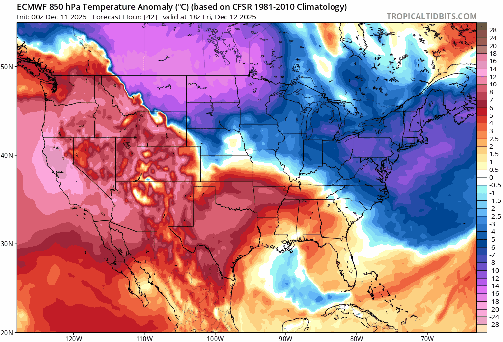
A key factor in the likely accumulating snow event later this weekend across the Mid-Atlantic region and I-95 corridor will be a vigorous jet streak aloft which will enhance upward motion in the area. Map courtesy NOAA, tropicaltidbits.com
Overview
In the wake of yesterday’s “clipper” system, another Arctic air mass is pouring into the northeastern states on stiff NW winds and temperatures today will struggle to climb from early day levels. In addition, snow showers are likely in parts of the area and heavier snow squalls can develop causing travel headaches across some interior, higher elevation locations. Another “clipper” system will reach the Mid-Atlantic region on Friday, and it’ll gradually weaken during the day as it loses some of its upper-level support and this will limit its impact on the DC-to-Philly-to-NYC corridor.
By later tomorrow, the next Arctic air mass will plunge into the north-central US from Canada and this one will be brutal...potentially the worst of the bunch since the cold pattern developed around Thanksgiving Day. Temperatures this weekend can drop to 20 degrees below zero in parts of the region from Montana to Wisconsin and wind chills can reach dangerously low levels. Meanwhile, yet another “clipper” system will push east-southeast crossing over central Plains, Midwest and Ohio Valley on Saturday and then into the Mid-Atlantic region by Saturday night. This system will feature some strong support in the upper atmosphere with a vigorous jet streak and has the potential of producing accumulating snow in the Mid-Atlantic region from late Saturday into early Sunday. Arctic air that invades the north-central states on Friday and Saturday will then spread to the northeastern states on Sunday following the passage of this next “clipper” system.
Arctic air is pouring into the northeastern states today in the wake of yesterday’s “clipper” system and the next Arctic blast arrives in the north-central states by tomorrow night/early Saturday. This next blast will mean business with some serious cold and numerous record or near record low temperatures are possible this weekend. Maps courtesy ECMWF, tropicaltidbits.com
Details
In the wake of a “clipper” system that pushed well to the north and west of the I-95 corridor on Wednesday, another Arctic air mass is riding into the Mid-Atlantic region today on strong northwesterly winds that can reach 40 mph or so. Temperatures will be reluctant to climb from early morning levels which are far below normal for this time of year. In addition to the wind and Arctic chill, lake-effect snow bands are forming just downstream of the still relatively warm lake waters and there can be snow shower activity in any part of the Mid-Atlantic region and snow squalls are even possible across some of the interior, higher elevation locations (e.g., north of I-80 in upstate PA).
On Friday, the next in a series of “clipper” systems will produce accumulating snow in the Ohio Valley and then head towards the Mid-Atlantic region. The upper-level support for this system will tend to diminish during the day on Friday; therefore, any appreciable snow will likely be limited to western sections of the Mid-Atlantic such as in the southwestern part of Virginia which has been a hot spot so far this season for snowfall. Indeed, only a touch of snow is possible in the DC-to-Philly-to-NYC corridor on Friday given the expected weakening of the “clipper” as it tries to push eastward.

Actual air temperatures can drop to twenty or twenty-five degrees below zero this weekend across parts of the Northern Plains/Upper Midwest…wind chills will be even lower with dangerously low levels in some areas. Map courtesy NOAA, Dr. Ryan Maue (X), weathermodels.com
By late tomorrow and early Saturday, another Arctic air mass will invade the north-central US from Canada, and this one will be brutal...perhaps the worst of all since this cold pattern got cranking around Thanksgiving Day. Temperatures could drop to twenty degrees below zero across portions of Montana, Minnesota, and Wisconsin this weekend and wind chills will become dangerously low in many areas. Look for numerous record or near record low temperatures from the Northern Plains to the Great Lakes/Midwest early in the weekend and that threat of record-breaking cold may shift to the northeastern states by the end of the weekend and early part of next week.
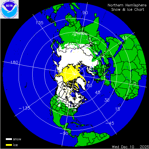
Virtually the entire country of Canada is now covered by snow as we approach the middle of December as is Greenland and Siberia on the other side of the North Pole…all of these areas are important cold air source regions for the US. Map courtesy NOAA
Yet another “clipper” system will head in an east-to-southeast direction on Saturday crossing over the central Plains, Midwest and Ohio Valley, and this is the one with the greatest potential of producing accumulating snow in the Mid-Atlantic region including the I-95 corridor. When this system arrives in the Mid-Atlantic on Saturday night, it looks like it will have quite a bit of upper-level support; specifically, in terms of a powerful jet streak. This jet streak is likely to generate strong upward motion across the Mid-Atlantic on Saturday night and Sunday morning assuring there is no weakening as compared with the Friday “clipper” system. The result is likely to be accumulating snow from late Saturday into early Sunday in the Mid-Atlantic and this should include the I-95 corridor region from DC-to-Philly-to-NYC. Current snowfall estimates are in the “light-to-moderate” range, but there are still a few days to go, and an upward trend is possible.

An early estimate of snowfall amounts in the Mid-Atlantic region is shown here for the weekend “clipper” system using a “National Blend of Models or NBM”. There are still a few days to go and an upward trend is possible…stay tuned. Map courtesy NOAA, Weather Bell
Following any snow that falls on Saturday night and Sunday morning, Arctic air that will be centered over the Great Lakes and Midwest will flood the northeastern states riding in on stiffening NW winds. The Arctic chill that arrives on Sunday in the northeastern states will stick around into Tuesday with well below normal temperatures for mid-December. Looking ahead, there is likely some noticeable warming on the way for the latter part of next week across the northeastern states. One final note, football games on Sunday will certainly be affected by this next Arctic air outbreak with very windy and cold conditions expected in Philly (1pm, Eagles vs Raiders) and New York City (1pm, Giants vs Commanders) and especially in Chicago where the Bears play the Browns at 1pm and temperatures will struggle to pass much above the ten degree mark for afternoon highs...btw, only 60 days until spring training.
Meteorologist Paul Dorian
Arcfield
arcfieldweather.com
Follow us on Facebook, Twitter, YouTube
Video discussion: