
***Soaking rain event from late Thursday night into Friday morning...maybe even a gusty thunderstorm...strong winds to follow on Friday with dropping temperatures and scattered snow showers***
Paul Dorian
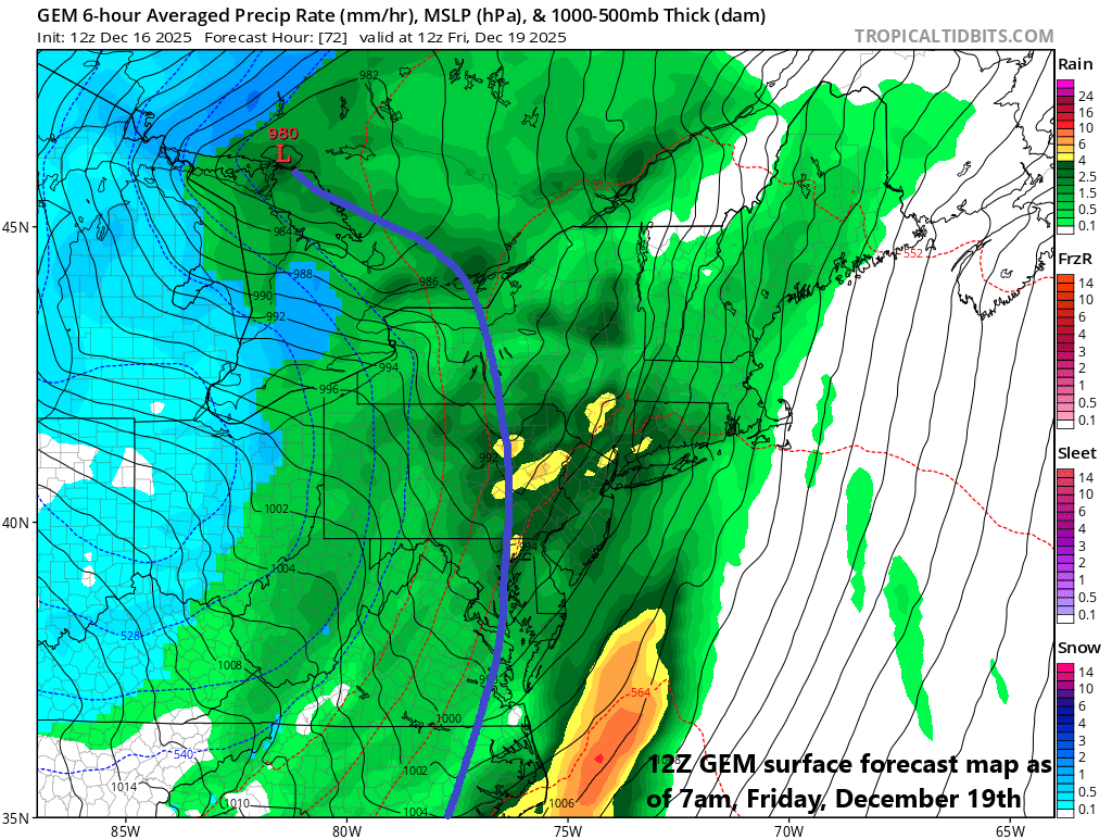
As the strong cold front approaches the Mid-Atlantic region late Thursday night/early Friday morning, the rain can fall heavily at times and there can even be a gusty thunderstorm in the area. Map courtesy Canadian Met Centre, tropicaltidbits.com
Overview
The next big weather event in the Mid-Atlantic region will feature rain associated with a strong cold front and there can even be a thunderstorm in the mix before the frontal system clears the area. The rain can come down hard at times from late Thursday night into Friday morning and - given the current snow cover in much of the area – we’ll have to watch for the possibility of some localized flooding. The strong cold front will pass through the Mid-Atlantic region during Friday morning, and strong winds will develop on its backside from a northwesterly direction gusting to 40 mph or so...even higher wind gusts are likely across New England. In addition, temperatures are likely to drop markedly as the cold air mass pours into the region and snow showers are likely to develop; especially, in some of the higher elevation interior locations. The weather will settle down for the weekend with dry conditions expected on both days and a moderate chill in the air.
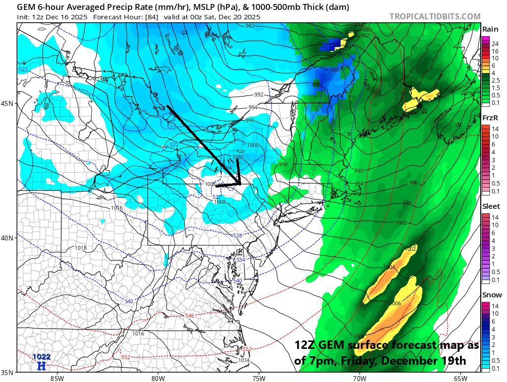
After the strong cold front clears the east coast on Friday, temperatures will drop markedly, winds will pick up noticeably from a northwesterly direction, and snow showers will form just downstream of the Great Lakes. Map courtesy Canadian Met Centre, tropicaltidbits.com
Details
It’ll turn milder during the next couple of days in the Mid-Atlantic region which will set the stage for a big-time rain event from late Thursday night into Friday morning. The entrenched Arctic air mass that has resulted in far below-normal temperatures around here during the past few days will finally give up its ground during the mid-week time period as high pressure shifts to the east and a southwesterly flow of air forms in the lower levels of the atmosphere. The cold pattern that we have suffered through in the Mid-Atlantic region since around Thanksgiving Day has been relentless with twenty consecutive days of below-normal temperatures in some spots (e.g., DCA).
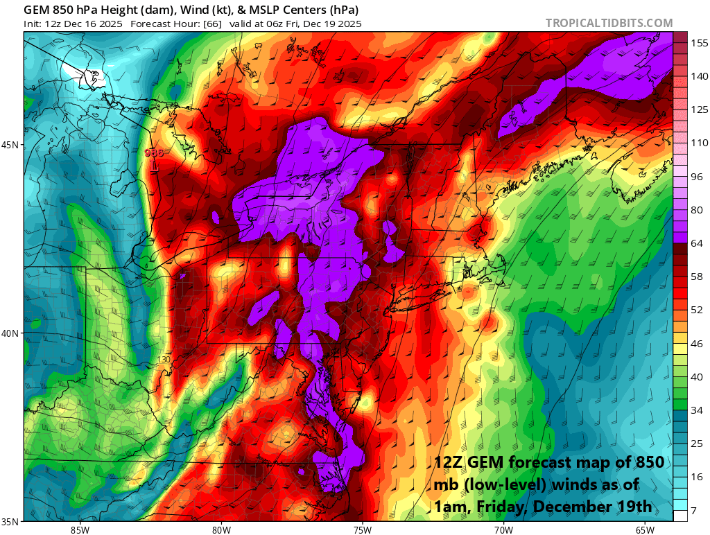
Wind gusts may reach into the 40-50 mph range in the Mid-Atlantic region late Thursday night and Friday as the strong cold front sweeps through the area. In addition to the winds, temperatures are likely to drop markedly post-frontal passage and snow showers will form just downstream of the Great Lakes. Map courtesy Canadian Met Centre, tropicaltidbits.com
On Thursday, a strong cold front will cross the Ohio Valley and temperatures ahead of it will climb to the highest levels seen around here in quite awhile with some spots reaching 50+ degrees for afternoon high temperatures (e.g. DC, Philly). It’ll likely stay dry through the daytime hours on Thursday, but then periods of rain will develop later in the evening all along the DC-to-Philly-to-NYC corridor. The rain can come down hard in the overnight hours and a gusty thunderstorm cannot be ruled out as the cold front sweeps towards the eastern seaboard. Given the remaining snow cover in some areas, the combination of soaking rain and melting snow could result in some localized flooding so be on the lookout for that; especially, in those areas with the deepest snowpack (e.g., SE PA, central NJ).
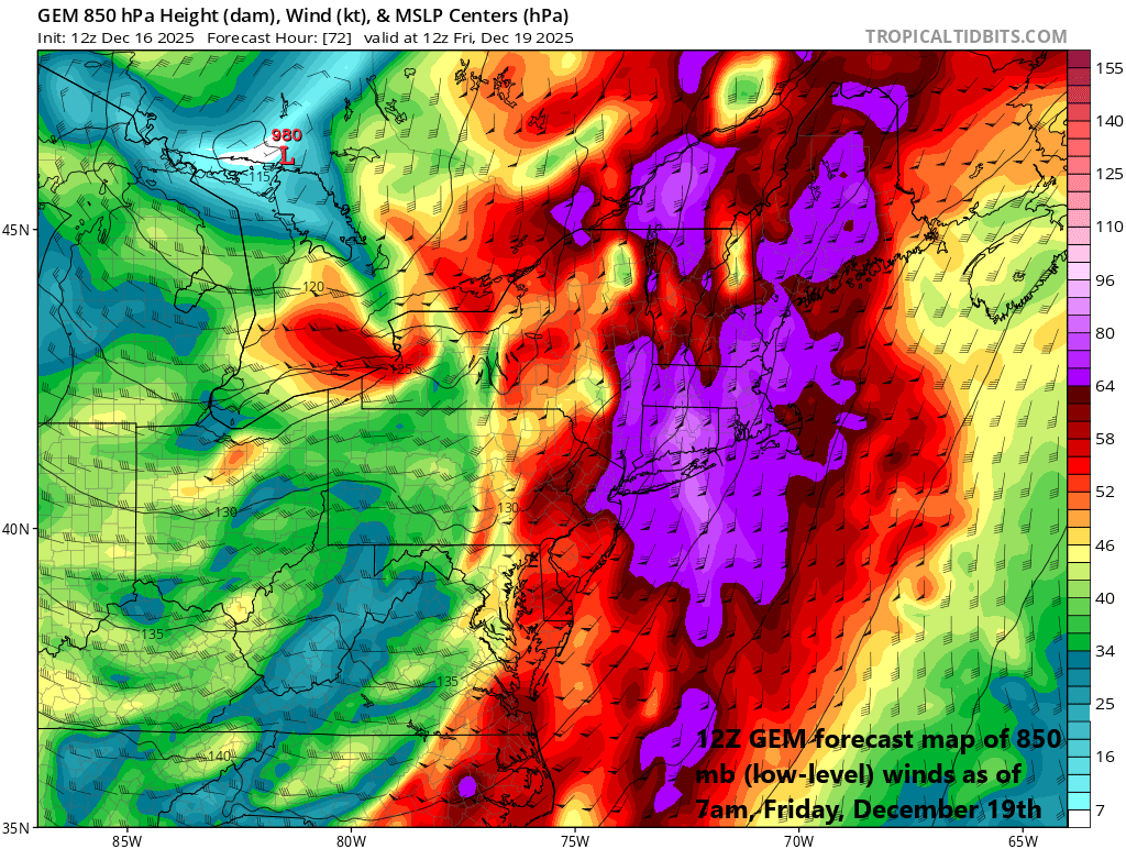
Wind gusts may reach damaging levels (50-60 mph) across New England on Friday as the strong cold front sweeps through the region. In addition to the winds, temperatures are likely to drop markedly post-frontal passage and snow showers will form just downstream of the Great Lakes. Map courtesy Canadian Met Centre, tropicaltidbits.com
On Friday morning, the strong cold front will sweep off the east coast, the rain will come to an end, winds will increase from a northwesterly direction, and temperatures are likely to drop markedly. Snow showers are likely to form with the cold intrusion of air; especially, in those higher elevation interior locations of the Mid-Atlantic region (e.g., areas to the north of I-80 in upstate PA). The weather should quiet down this weekend with some sunshine likely on both days in the Mid-Atlantic region and temperatures will be moderately chilly for this time of year.
Meteorologist Paul Dorian
Arcfield
arcfieldweather.com