
****Plenty of winter weather for the northeastern states during the next week or so...accumulating snow, significant icing on the table and more Arctic air outbreaks****
Paul Dorian
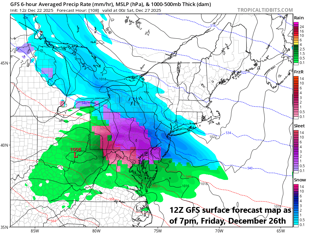
The day after Christmas may be filled with frozen precipitation across portions of the Mid-Atlantic/Northeast US with strong high pressure positioned over eastern Canada. Map courtesy NOAA, tropicaltidbits.com
Overview
While the nation’s mid-section enjoys rarely ever-seen sustained warmth for Christmas week, the northeastern states will experience plenty of winter weather during the next 7 days or so. One system will bring some snow and ice to the northern Mid-Atlantic region and Northeast US from late tonight into Tuesday and though not a significant event, there can be some slippery spots tomorrow even in the big cities along the I-95 corridor from Philly-to-Boston. Another storm could threaten the Mid-Atlantic region and Northeast US with accumulating snow and significant ice at the end of the week with strong high pressure positioned over eastern Canada anchoring an Arctic air mass. By the end of the upcoming weekend, another low pressure will slide to the Great Lakes, and its training cold front will head to the east coast. This combination can produce rain, ice and snow across the northeastern states late in the weekend and it’ll be followed by another Arctic air outbreak for the first part of next week.
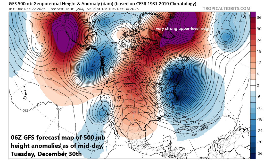
Strong ridge of high pressure that has been parked over Scandinavia in recent weeks will retrograde during the next week or so and shift to near Greenland, Iceland, and northeastern Canada by early next week. Map courtesy NOAA, tropicaltidbits.com
Details
A cold front passed through the northeastern states on Sunday, and the new work week has started off with below-normal temperatures despite an abundance of sunshine. The sunshine will fade away later today as clouds expand in coverage along a warm frontal boundary zone that extends to the south and east of a low-pressure system located just to the north of the Great Lakes. Precipitation will break out later tonight across the Mid-Atlantic and then push northeastward on Tuesday into the New England area. It should be cold enough for primarily snow to fall late tonight/early Tuesday all the way down to the PA/MD border and then a mixed bag is likely for awhile before the precipitation winds down by mid-day as plain rain. While snowfall will be limited by low snow ratios with a coating to an inch or so in most places in the Mid-Atlantic, there certainly can be some slippery spots on Tuesday as temperatures however for awhile at or just below the freezing mark. In some of the higher elevation locations of northeastern PA and interior NW NJ, a couple of inches of snow could accumulate before a mixture takes place in those spots. To the south of the Mason-Dixon Line, there can be a touch of sleet and/or snow late tonight/early Tuesday, but little to no snow accumulation is anticipated in, for example, the DC metro region.
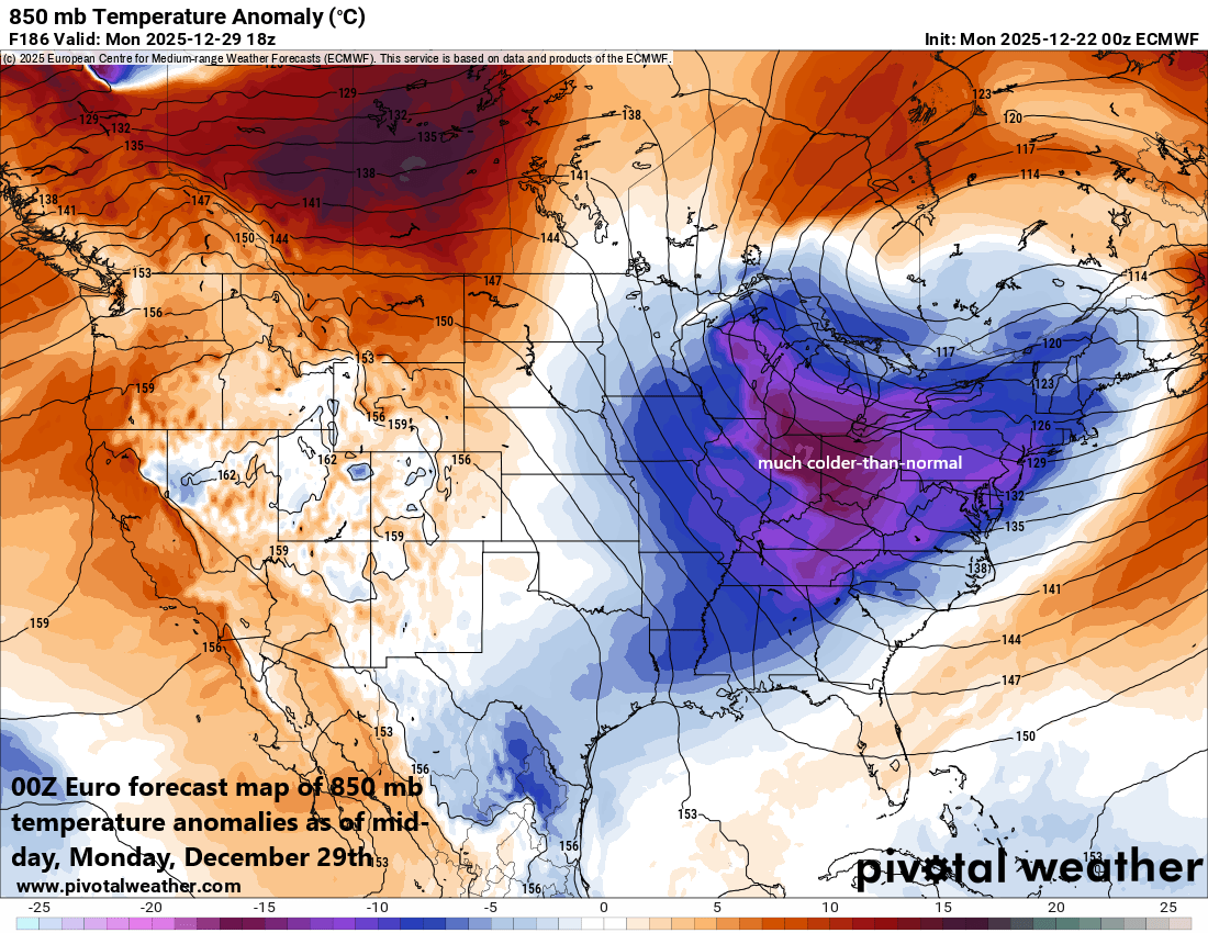
Yet another Arctic air outbreak is destined to reach the northeastern part of the country by early next week on the heels of a strong cold frontal passage. Map courtesy ECMWF, Pivotal Weather
For the mid-week, generally dry, and moderately chilly conditions will rule for the northeastern states, which is good news as it can be a busy travel day ahead of the Christmas holiday which falls on Thursday. By late Thursday, a key player for the week weather pattern will be strong surface high pressure developing over the Hudson Bay region of Canada and this will be supported by an upper-level ridge that begins to intensify near Greenland. The high-pressure over eastern Canada will act as a cold air source region for the northeastern states by the time we get to the end of the work week.
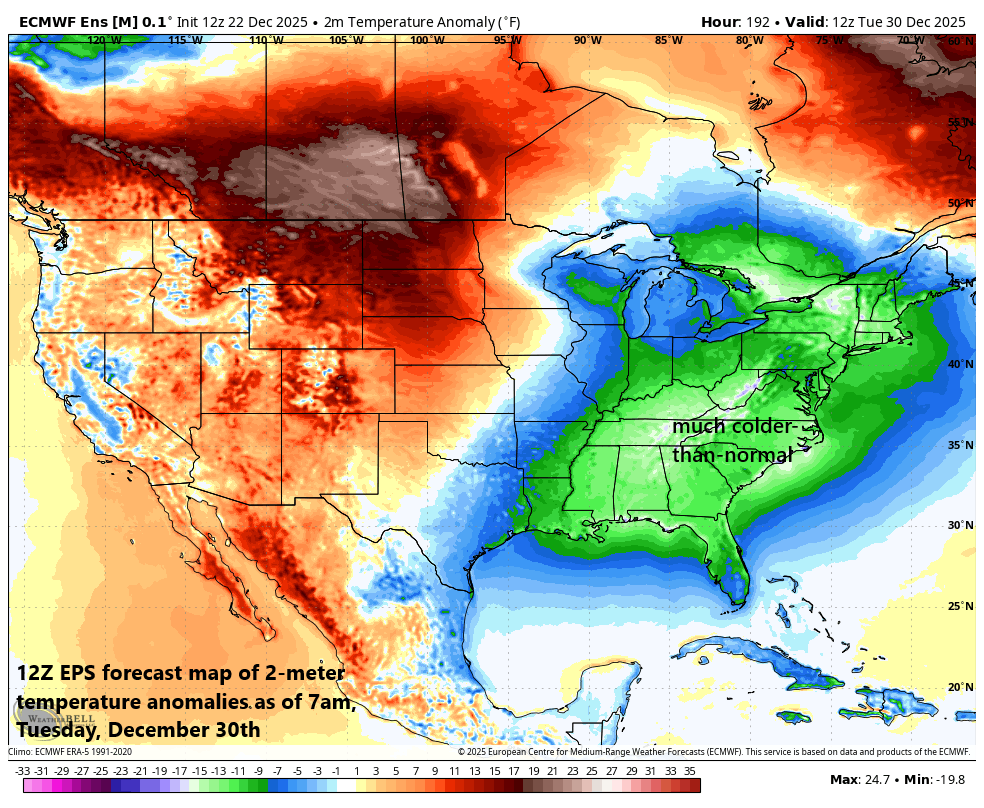
Arctic air brings much colder-than-normal weather to much of the eastern half of the nation by next Tuesday, December 30th. Map courtesy ECMWF, Weather Bell
At the same time this strong high-pressure system builds over eastern Canada, low pressure will drop south and east to the Great Lakes from south-central Canada. This is indeed yet another “clipper” type of system that rides from northwest-to-southeast along the polar jet stream – a common pattern in La Nina winters – and its moisture field will tend to expand in coverage as we get to Friday, December 26th. With cold air likely to “feed” into the northeastern states by the end of the week from the north, this expanding moisture field associated with the “clipper” system could result in significant icing in some parts of the northeastern US and accumulating snow in others.
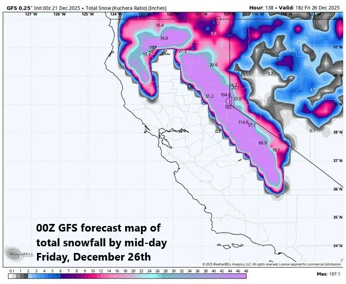
Winter weather will not be confined to the northeastern part of the country this week…substantial snow will accumulate in the Sierra Nevada Mountain range of eastern California by the upcoming weekend with as much as 100 inches possible in some of the higher elevation locations. Map courtesy NOAA, Weather Bell
On the heels of the late week system, the upcoming weekend should start off on the chilly side in the Mid-Atlantic and Northeast US. By the latter part of the weekend, yet another low-pressure system is going to push to the Great Lakes region, and its trailing cold front will slide towards the east coast. It might be too warm for frozen precipitation in much of the Mid-Atlantic late in the weekend, but snow and ice could certainly be a factor in the Northeast US. Following the passage of the cold front, another Arctic air mass will flood the northeastern states, bringing well below-normal temperatures to the region for the first part of next week, and there can be snow shower activity once again just downstream of the Great Lakes.
Meteorologist Paul Dorian
Arcfield
arcfieldweather.com
Video discussion: