***Winds kick up as much colder air arrives...2026 starts with another Arctic blast and perhaps some snow...two important developments in the atmosphere increase east coast storm chances***
Paul Dorian

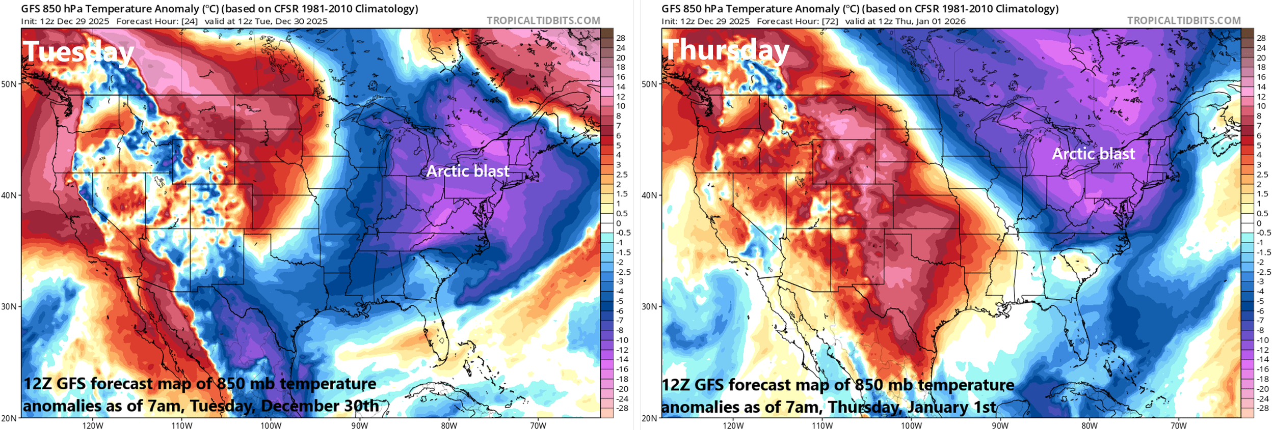
The next few days will feature not one, but two Arctic blasts across the northeastern states with the first arriving later today/tonight and a second one pushing in on Wednesday night and Thursday. Maps courtesy NOAA, tropicaltidbits.com
Overview
A powerful cold front will barrel through the region during the next couple of hours and the winds should kick up dramatically as much colder air plunges into the northeastern part of the country. In fact, gusts can reach 50 mph this afternoon and evening in the Mid-Atlantic region from the usual post-cold frontal direction of west-to-northwest. This incoming blast of cold air will be followed quickly by a second one right around the time we transition to the new year on Thursday and that influx of Arctic air may be accompanied by some snow. As we go through the medium-term, two important changes in the atmosphere will be unfolding, and they can lead to an increased chance of an east coast storm and accumulating snow in the Mid-Atlantic region.
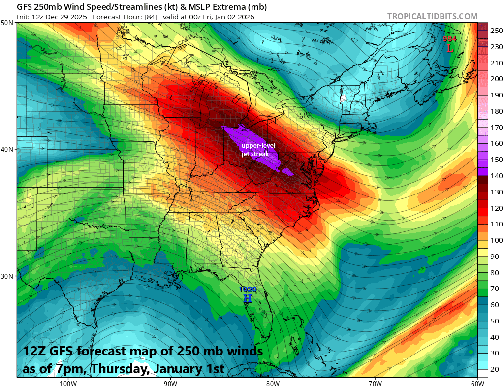
A strong upper-level jet streak will rotate through a large-scale trough of low pressure on Wednesday night and Thursday and this feature can help to generate snow showers in the I-95 corridor…perhaps even a period of steadier snow as we begin the new year. Map courtesy ECMWF, Weather Bell Analytics
Arctic blasts to end December and begin the new year
A powerful cold front will sweep off the east coast early this afternoon and winds will pick up noticeably on its heels with gusts possible to 50 mph from a west-to-northwest direction. Temperatures peaked earlier today at quite mild levels ahead of the cold front and will drop sharply this afternoon in the wake of its passage with the 30’s likely by late afternoon. With continued strong winds on Monday night and Tuesday, it’ll feel even colder than the actual outdoor temperatures and there can be a snow shower or two in the immediate I-95 corridor region. Meanwhile, in areas just downstream of the Great Lakes, snow showers and snow squalls will dump accumulating snow through tomorrow with the classic setup for this time of year featuring bitter cold air flowing just above the still relatively warm lake waters. On Wednesday, a short wave in the upper atmosphere will rotate through a long-wave trough of low pressure generating additional snow showers across interior higher elevation sections of the Mid-Atlantic and Northeast US and the Arctic chill in the air will remain intact.
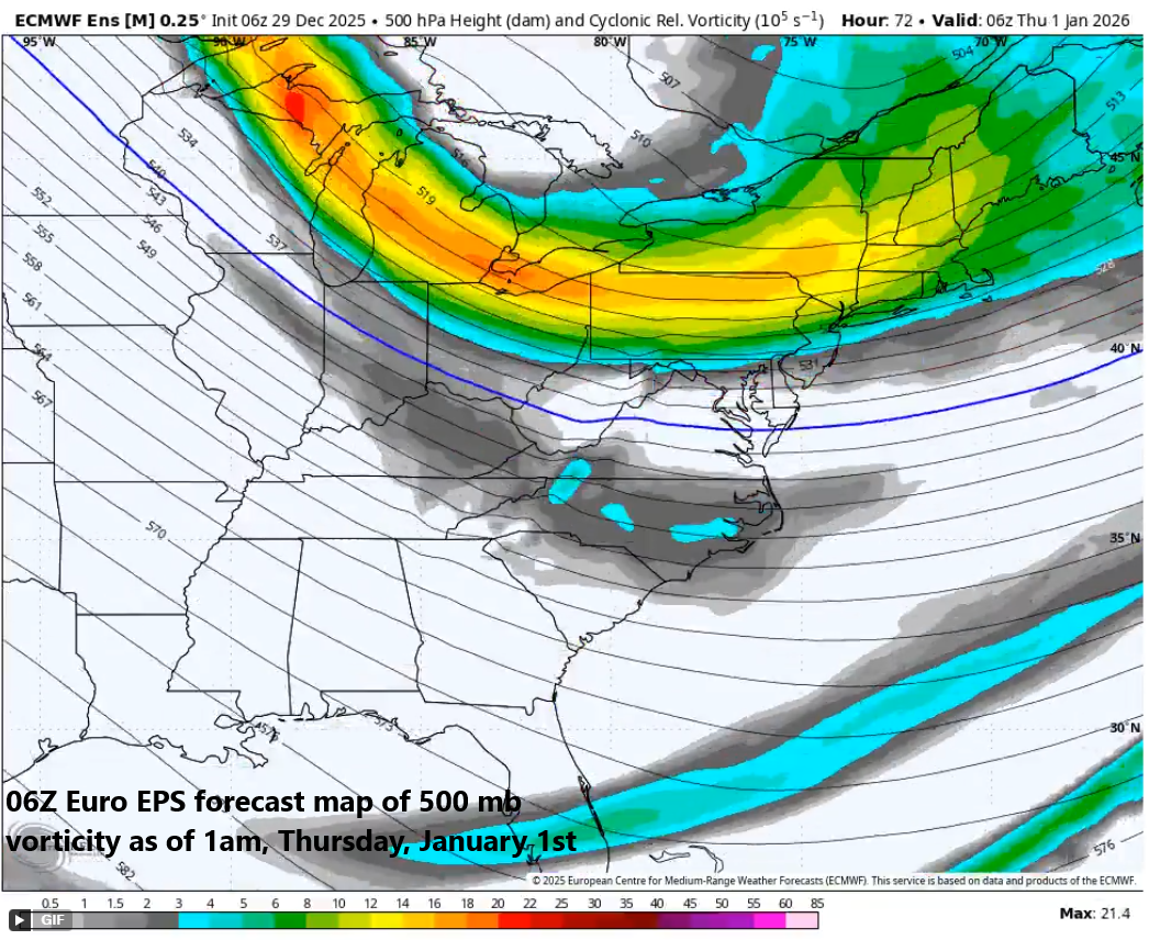
A strong short-wave will rotate through a large-scale upper-level trough on Wednesday night and Thursday and this system can produce snow showers in the I-95 corridor…perhaps even a period of steadier snow as we begin the new year. Map courtesy ECMWF, Weather Bell Analytics
By Wednesday night and Thursday an even stronger short-wave aloft will drop south and east into the Mid-Atlantic region from the Great Lakes. This system will be supported aloft by a vigorous jet streak which can increase the chance for snow showers even into the immediate I-95 corridor region of DC, Philly and NYC... and perhaps even a period of steadier snow. This threat of snow is currently not being picked up by the computer forecast models; however, the likelihood of a strong jet streak raises a red flag to me for a possible surprise snow...something to monitor during the next couple of days.
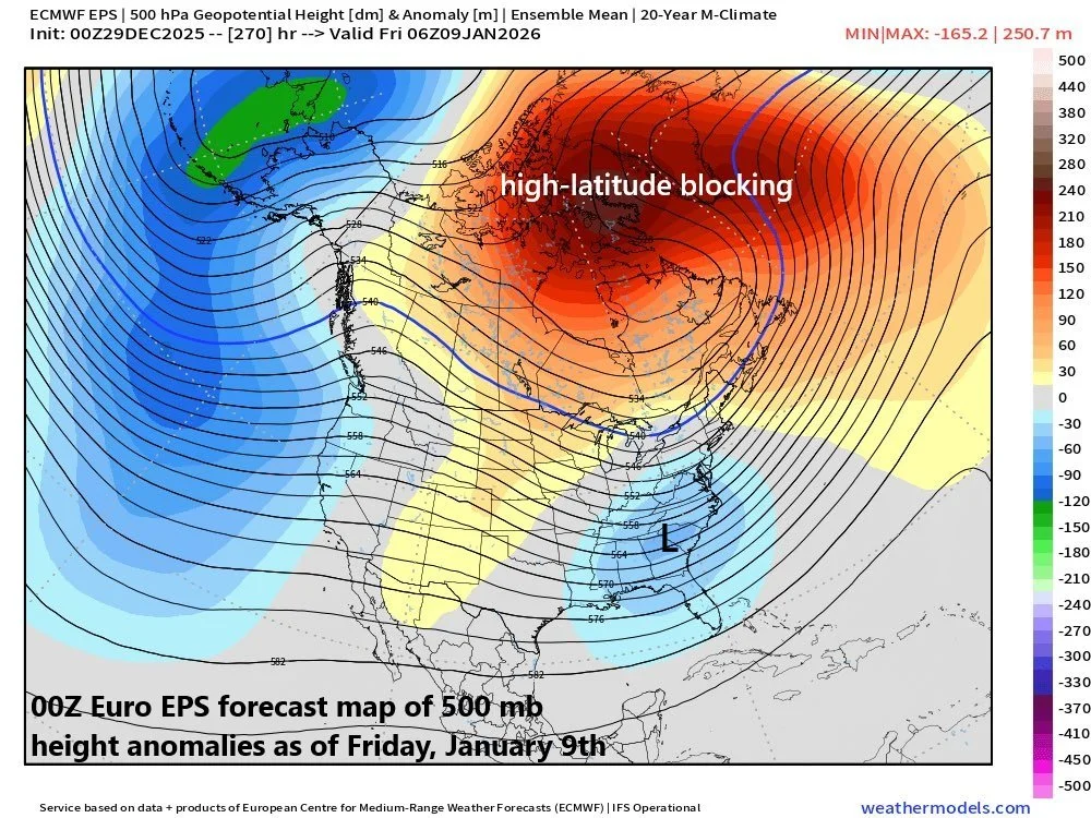
By later next week, the overall 500 mb height pattern across North America could feature strong high-latitude blocking centered over northern Canada/Greenland (shown in orange) and an upper-level trough in the Southeast US (shown in blue) supported by a more active southern branch of the jet stream. Map courtesy ECMWF, weathermodels.com
High-latitude blocking
Meanwhile, two important changes are unfolding in the environment across North America which could ultimately increase chances for east coast storms and accumulating snow in the Mid-Atlantic region. First, high-latitude blocking is seemingly kicking into gear across places like Greenland, Iceland and northern Canada, and teleconnection index trends suggest to me this is not going to be a short-term change (NAO, AO in “negative” territory for a sustained time). In fact, high-latitude blocking across North America which was largely absent during the past few weeks may actually intensify and expand in coverage as we progress through the first couple weeks of January. This kind of an overall upper-level pattern tends to favor the forcing of cold air masses from Canada into the eastern US and can lock in the cold for an extended period of time...all favorable, of course, for the prospects of accumulating snow.
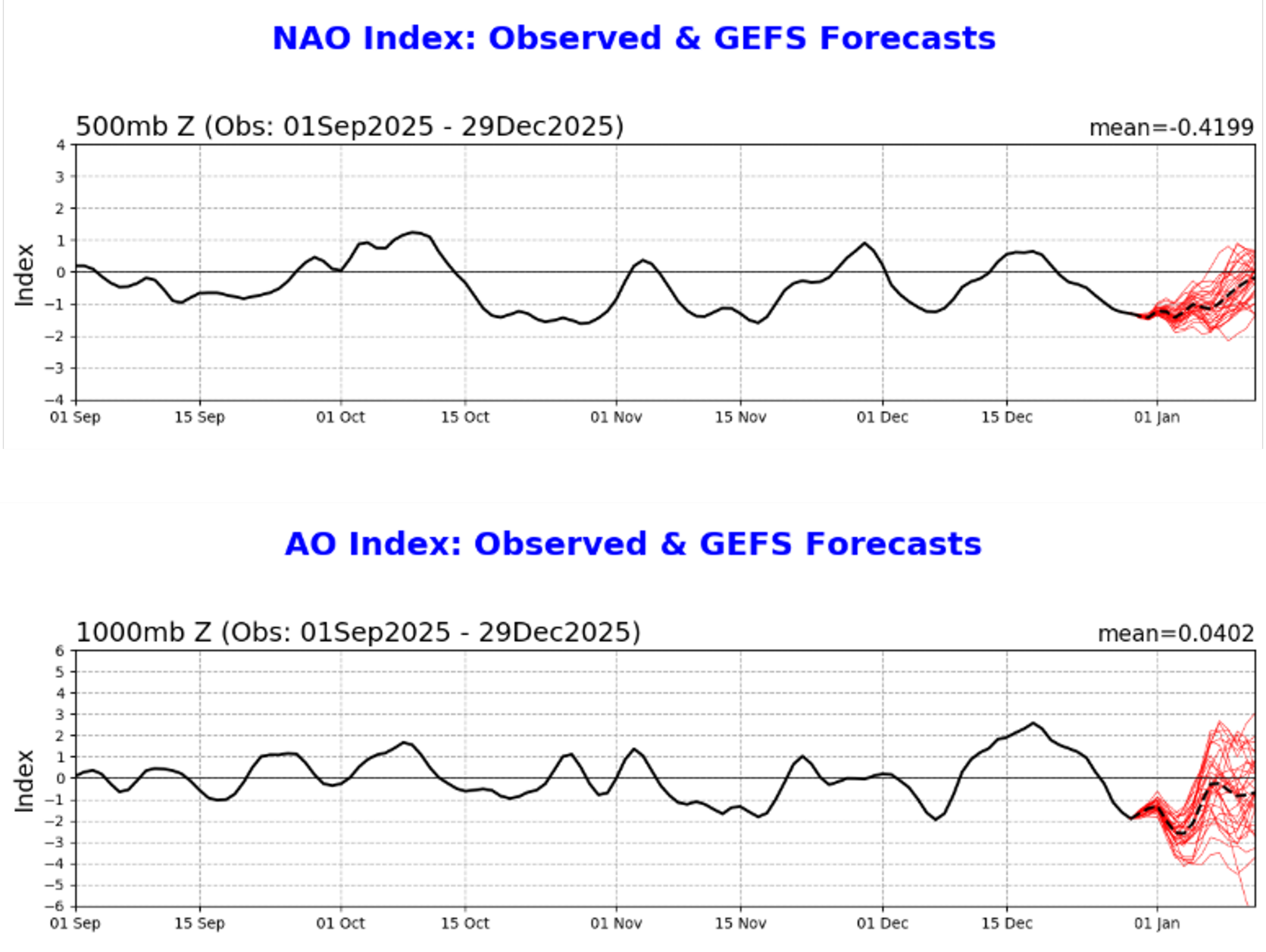
The North Atlantic Oscillation (NAO) and its closely related cousin, Arctic Oscillation (AO) will spend much of their time through the next couple of weeks in “negative” territory. This kind of trend in these teleconnection indices usually correlates well with strong high-latitude blocking across North America. Plots courtesy NOAA
Activation of the southern branch of the jet stream
In addition to the increasing prospects of sustained high-latitude blocking, there are signs that the sub-tropical jet stream will become more active in coming weeks as compared with the last month or so when it was largely absent in the overall pattern as the polar jet dominated. If the southern branch of the jet stream does, in fact, become more of a factor then that could in turn lead to more southern storms which ultimately can climb up along the eastern seaboard likely with copious amounts of available moisture...something to monitor in coming days.
Buckle up...the combination of high-latitude blocking and an activation of the southern jet could produce results as early as the second half of next week (i.e., an east coast storm with accumulating snow in the Mid-Atlantic region).
Meteorologist Paul Dorian
Arcfield
arcfieldweather.com
Follow us on Facebook, Twitter, YouTube
Video discussion: