***A cold start to the new year with a fresh batch of Arctic air...”short-wave” enhanced snow showers from Wednesday evening into early Thursday...cold signals for the month of January***
Paul Dorian

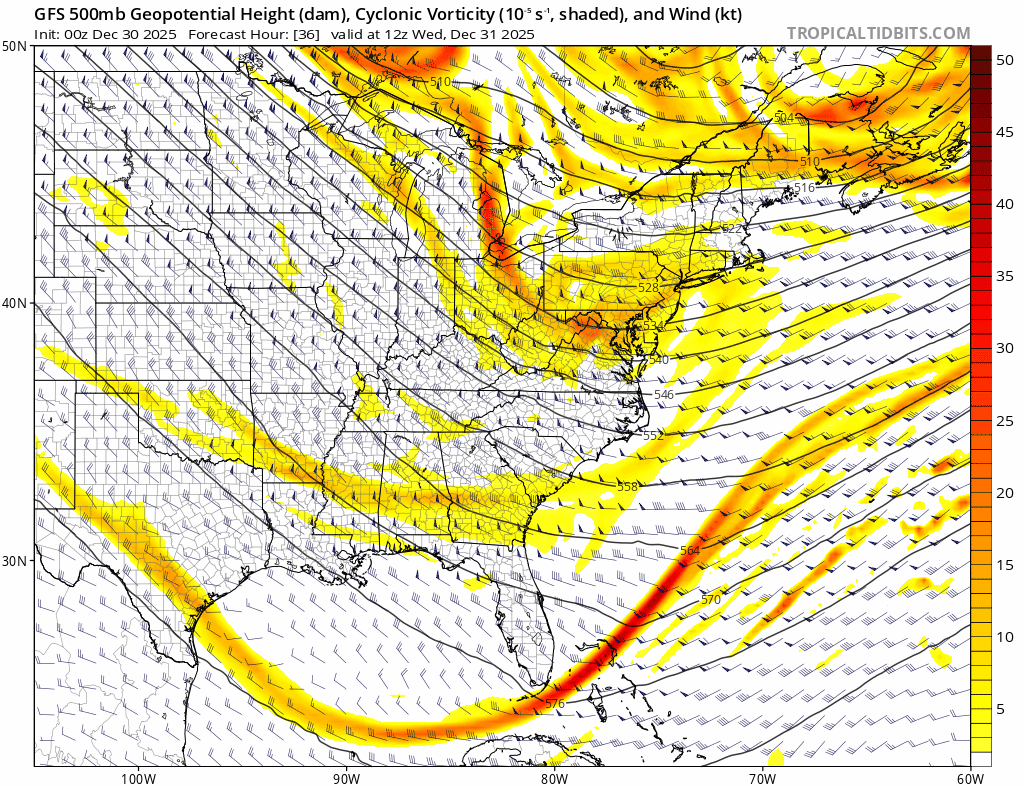
Two upper-level short-waves of energy will rotate through a long-wave trough during the next few days and can enhance lake-effect snow shower activity. The second and stronger of the two short-waves can produce some small accumulations in the DC-to-Philly-to-NYC corridor from late Wednesday night into early Thursday…right as we begin the new year. Maps courtesy NOAA, tropicaltidbits.com
Overview
The passage of a strong cold front on Monday ushered in an Arctic air mass to the Mid-Atlantic region and Northeast US and it is being accompanied by very strong winds that can gust today up to 50 mph or so. A reinforcing Arctic blast will arrive to start the new year on Thursday, and temperatures will remain well below-normal for the first few days of January. Looking ahead, numerous signs point to a continuation of the colder-than-normal pattern across the northern US as we progress through January and some extreme cold could get into the mix.
In addition to the wind and cold, the next few days in the Mid-Atlantic and Northeast US will also feature a couple of upper-level “short-wave” disturbances that will rotate through a “long-wave” trough of low pressure now centered over the northeastern states. As a result, there can be snow showers at various times including late tonight and early tomorrow from one disturbance and again late tomorrow night to early Thursday from a second disturbance. This second “short-wave” is the stronger of the two and small snow accumulations cannot be ruled out – even in the immediate I-95 corridor from DC-to-Philly-to-NYC – right as we begin the new year on Thursday.
Arctic cold, strong winds
A powerful cold front swept off the east coast on Monday, and the winds picked up dramatically on its heels with gusts reaching 50 mph or so from a west-to-northwest direction. The strong winds will continue through much of today in the Mid-Atlantic and Northeast US and can again gust to 50 mph or so. Meanwhile, in areas just downstream of the Great Lakes, lake-effect snow showers and snow squalls have developed and can produce some accumulating snow during the next several hours across western Pennsylvania and New York State with the classic setup featuring bitter cold air flowing just above the still relatively warm lake waters.
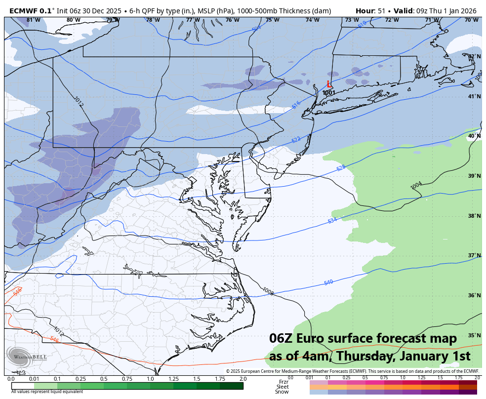
A short-wave upper-level disturbance will bring the chance for enhanced snow showers from late Wednesday night into early Thursday…even into the immediate I-95 corridor region from DC-to-Philly-to-NYC…small accumulations are on the table as we begin the new year. Map courtesy ECMWF, Weather Bell Analytics, Tony Pann (X)
“Short-wave” enhanced snow shower chances
By later tonight, an upper-level “short-wave” will drop south and east across the Great Lakes and enhance the lake-effect snow shower activity resulting in some (additional) accumulations across Michigan, Ohio and western Pennsylvania...some of this snow shower activity can make its way into the I-95 corridor region late tonight or early Wednesday.
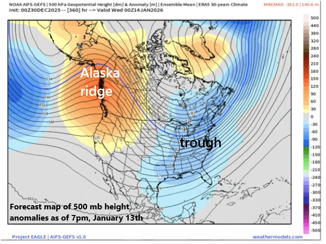
Signs point to the formation of an Alaskan ridge of high pressure in the upper part of the atmosphere by the middle of January combined with some high-latitude blocking over Canada and a trough of low pressure over the eastern states…a combination that favors colder-than-normal weather across the central and eastern states. Map courtesy ECMWF, weathermodels.com, BAM Weather
By later Wednesday, an even stronger upper-level “short-wave” will drop south and east across the Great Lakes, and it will again enhance the lake-effect snow shower activity in many of these same areas from the Great Lakes to the Mid-Atlantic region. Indeed, this second and stronger upper-level disturbance has a better chance of producing small snow accumulations in the immediate I-95 region from DC-to-Philly-to-NYC from later Wednesday night into early Thursday - right at the beginning of 2026 – with enhanced snow showers or even a period of steadier snow. Temperatures will be well below normal on Thursday, January 1st, and continue to be on the cold side of normal as we head through the first weekend of the new year.
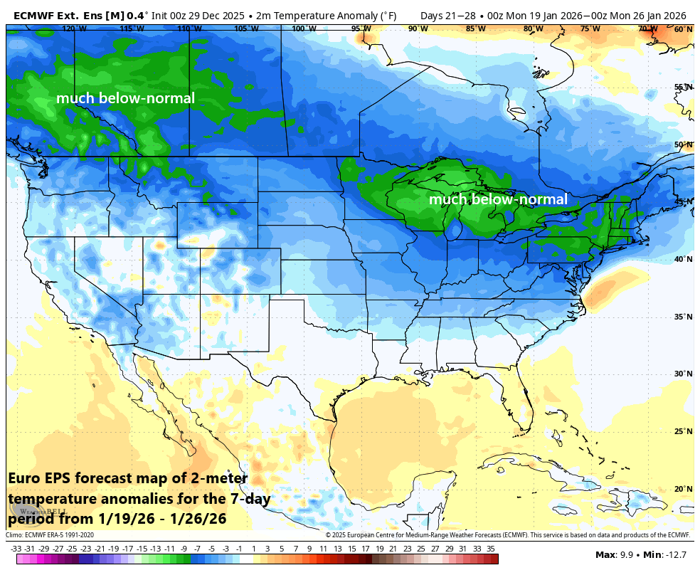
Very impressive cold look to this 2-meter temperature anomaly forecast map for the 7-day period from 1/19/26 to 1/26/26. Temperature departures from normal to this extend from this far out are impressive indeed and especially considering the computer forecast models have generally underestimated the cold air intrusions into the US from Canada. Map courtesy ECMWF, Weather Bell Analytics
A look ahead...signals point to many more Arctic cold blasts for the northern US
Looking ahead, numerous signals point to the continuation of a colder-than-normal pattern for the northern US as we progress through January. Specifically, the upper-level pattern for January looks like it will feature high-latitude blocking or higher heights than normal for much of the time across the northern part of Canada, Greenland and Iceland. In addition, there is reason to believe that a strong ridge of high pressure will develop across Alaska as we head through the new month. This combination of ridging over Alaska and northern Canada typically leads to favorable conditions for cold air masses from the Arctic region to drop southward into the central and eastern US.
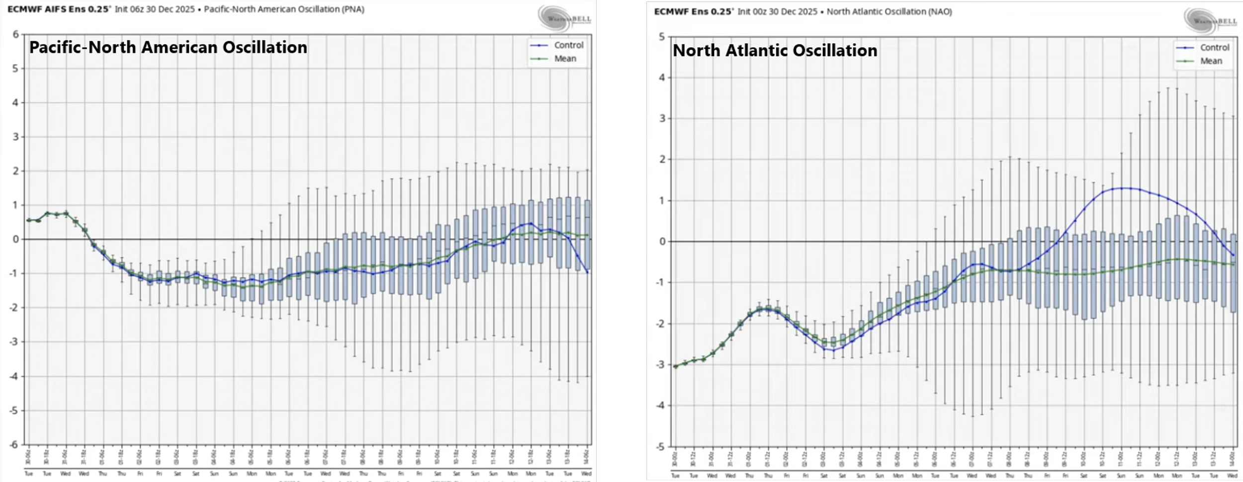
Teleconnection indices such as the Pacific-North American (left plot) and North Atlantic Oscillation (right plot) generally support the idea of the development of an Alaska ridge of high pressure (+PNA) and high-latitude blocking (-NAO, green line). Plots courtesy NOAA, Weather Bell Analytics, BAM Weather
Teleconnection indices such as the Pacific North America (PNA) and North Atlantic Oscillation (NAO) support the notion of the development of an Alaska ridge and high-latitude blocking over Canada (i.e., +PNA, -NAO). One final note, early indications of sharply negative temperature anomalies for the latter part of January suggest some extreme cold may be on the table given the fact that the latter part of January is the coldest time of year from a climatological point-of-view.
Meteorologist Paul Dorian
Arcfield
arcfieldweather.com
Follow us on Facebook, Twitter, YouTube
Video discussion: