
***Snow showers this evening as an Arctic front approaches...a late-night burst of heavy snow is possible...watching low pressure for the weekend...cold signals for second half of January***
Paul Dorian
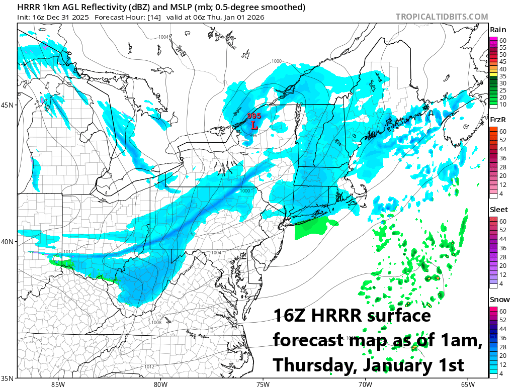
Snow showers are likely this evening in much of the Mid-Atlantic region; especially, to the north of the PA/MD border. By late tonight, a heavier snow band (seen in dark blue) may develop right along the cold front and this could impact the DC-to-Baltimore-Philly-to-NYC corridor in the 3-5 AM time period. Map courtesy NOAA, tropicaltidbits.com
Overview
A reinforcing shot of Arctic air will push into the Mid-Atlantic region in the overnight hours assuring a very cold start to the new year. The cold front that will usher in this next Arctic air mass will have some kick to it and it could spark a quick burst of heavy snow during the late-night hours which will follow snow showers in many areas this evening. Temperatures on the first day of the new year will be well below normal and will struggle to climb much past the 30-degree mark in the I-95 corridor region and strong northwest winds will make it feel even colder than the actual outdoor temperatures. The colder-than-normal weather pattern continues through the upcoming weekend and we’ll be monitoring low pressure over the Southeast US to see if it can come far enough to the north to impact the Mid-Atlantic region. Looking ahead, the cold pattern may relax for a week or so; however, numerous signals point to the return of the cold pattern before we get to the middle of the month.
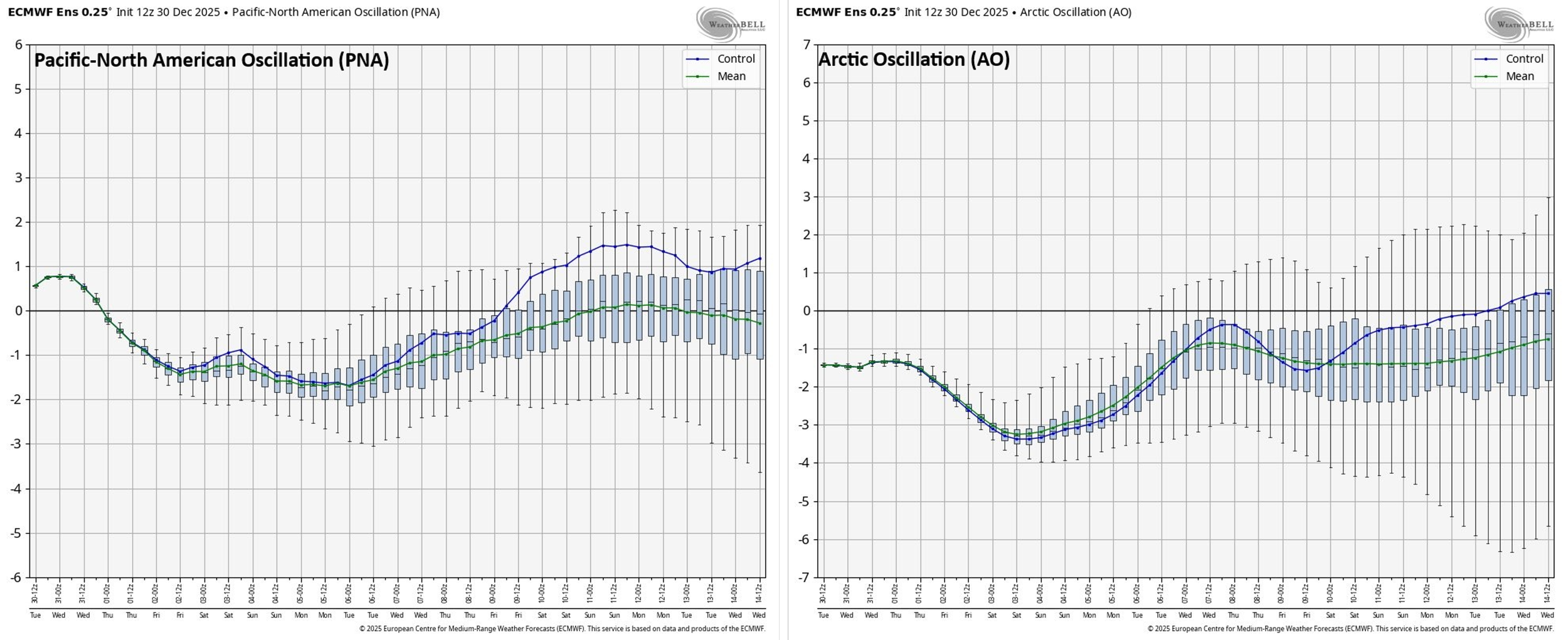
The PNA heads towards positive territory by around the 10th or so of January and this is typically correlated well with a ridge of high pressure that forms near Alaska. A “negative” AO is likely through the next couple of weeks which is usually favorable for colder-than-normal air in the central and eastern US. Maps courtesy ECMWF, Weather Bell Analytics
Evening snow showers...possible late night burst of heavier snow
One upper-level disturbance slid across the Mid-Atlantic region late last night and early today producing snow showers in some areas and a second one arrives later tonight. This second wave of energy in the upper atmosphere will combine with a strong cold front to generate snow showers in much of the Mid-Atlantic region this evening; especially, to the north of the PA/MD and that includes the NYC metro region around the midnight hour. A late-night burst of heavier snow is possible as the cold front arrives, and this threat exists all along the DC-to-Baltimore-to-Philly-to-NYC corridor. Any snow that falls this evening or late tonight can quickly coat the roads so watch out for potential slick spots; especially, during any burst of snow. Temperatures on Thursday will remain well below-normal struggling to pass the 30-degree mark and winds can kick up to 30 mph or so from a northwesterly direction. It stays colder than normal right through the upcoming weekend and there will be a low pressure system in the Southeast US on Saturday. This system may stay just to the south of the Mid-Atlantic region; however, it looks like a close call, and I’ll be watching for a possible northwest trend in its storm track during the next couple of days…in other words, it still can have an impact farther to the north along the eastern seaboard.
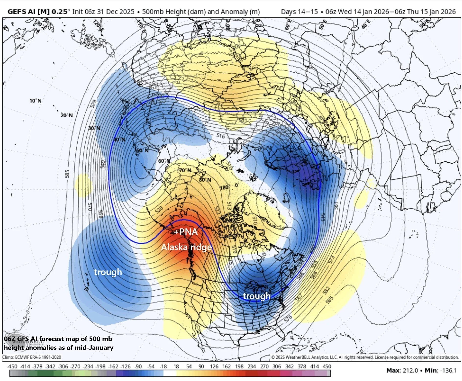
The middle of January could feature an upper air pattern with an Alaska ridge of high pressure and troughs of low pressure over the central Pacific and eastern US…this combination would be favorable for cold air intrusions from northern Canada (perhaps even from Siberia) into the central and eastern US. Map courtesy NOAA, Weather Bell Analytics
Signals point to more Arctic outbreaks after a relaxation in the cold pattern
Looking ahead, a relaxation in the cold pattern is likely to kick in for the northeastern states through much of next week, but there are numerous signals that point to a return of the colder-than-normal weather after about the 10th or so of January. Trends in teleconnection indices including the PNA, AO, WPO and EPO suggest the upper-level pattern over North America will evolve into one featuring a ridge of high pressure over Alaska and troughs centered near the central Pacific and eastern US.
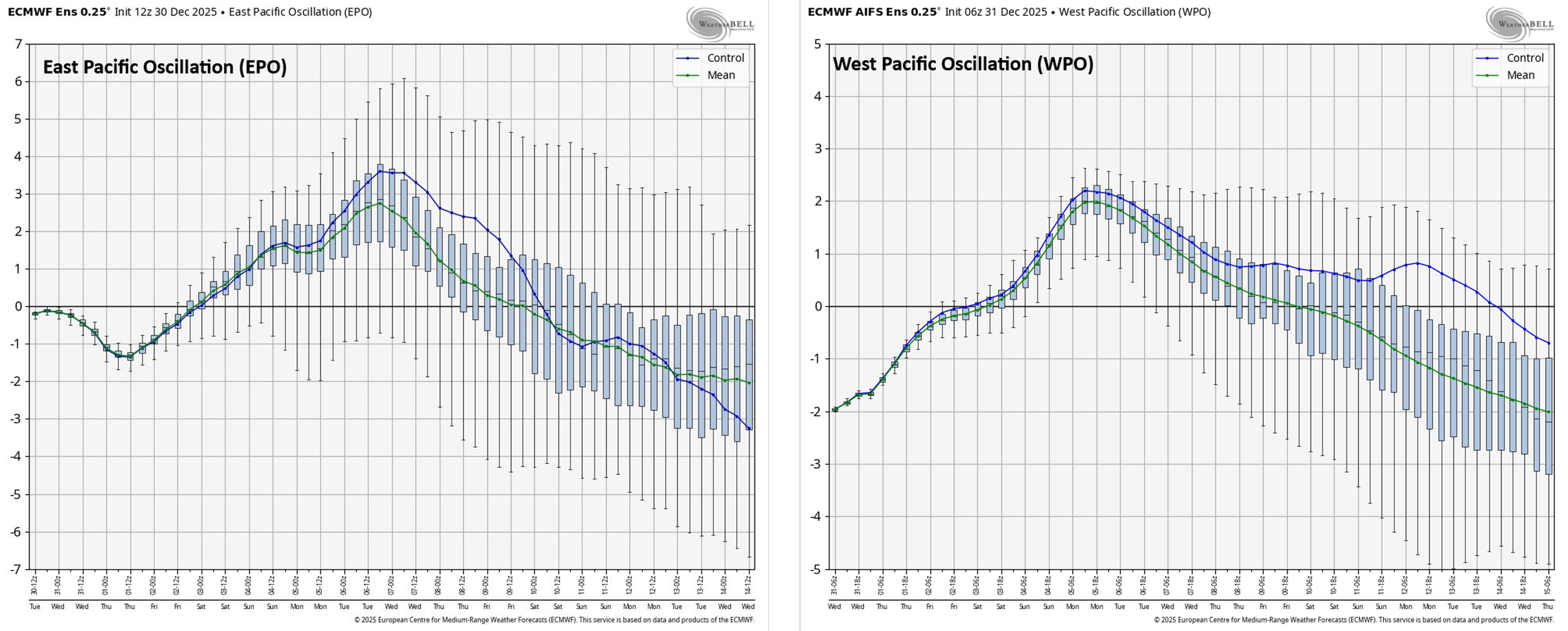
The EPO and WPO slide into “negative” territory by about the 10th or so of January and this trend suggests a trough of low pressure will form over the central Pacific Ocean and likely another one in the eastern US. Maps courtesy ECMWF, Weather Bell Analytics
This combination of troughs and ridges in these locations should be favorable for the transport of cold air masses from way up in Canada to the central and eastern US. In fact, this kind of upper-level pattern could introduce “cross polar flow” into the mix which would raise the possibility of some extremely cold air to make its way from the Siberian side of the North Pole to North America...stay tuned.
Meteorologist Paul Dorian
Arcfield
arcfieldweather.com
Follow us on Facebook, Twitter, YouTube
Video discussion: