
***A southern Mid-Atlantic snowfall on Friday with accumulations from DC/Virginia to the Delmarva to southern NJ...an Arctic blast that produced record lows today will set the stage for snow***
Paul Dorian

With Arctic air in place on Friday morning, snow is likely to break out across much of Virginia and in the DC metro region making for a potentially slippery AM commute in the nation’s capital. The snow will spread east to the Delmarva Peninsula and into the southern part of New Jersey…Philly, NYC metro regions will be on the northern fringes. Map courtesy NOAA
Overview
An Arctic blast that resulted in numerous record low temperatures this morning across the Upper Midwest/Great Lakes is on its way to the Mid-Atlantic region, and it will set the stage for an accumulating snow event on Friday in the southern half of the area from DC/Virginia to the Delmarva Peninsula to the southern part of New Jersey. Temperatures in the overnight hours will drop into the teens in many of the suburbs along the I-95 corridor following the passage of an Arctic cold frontal system later today. Moisture on Friday will spread to the northeast from the Tennessee Valley and run into this very cold and dry Arctic air mass and snow will break out early in the day across much of Virginia and the DC metro region...in other words, both the AM and PM commutes can be slippery in these areas on Friday.
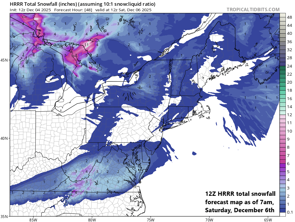
Accumulating snow is quite likely on Friday across much of the southern Mid-Atlantic region from DC/Virginia to the Delmarva Peninsula to southern New Jersey. As much as 2 or 3 inches of snow can fall in parts of the DC metro and 4 or 5 inches of snow is possible tomorrow across portions of central and southern Virginia. The Philly and NYC metro regions will be on the northern fringes of this low pressure system. Map courtesy NOAA, tropicaltidbits.com
Details
An Arctic front will slide across the Mid-Atlantic region later today...winds will increase ahead of it and there can be isolated snow showers in some areas; especially, to the north of the PA/MD border. Temperatures will tumble later tonight to the lowest levels observed so far this season with the teens likely in many suburban locations along the DC-to-Philly-to-NYC corridor. Temperatures on Friday will struggle to pass the freezing mark in most areas with plenty of clouds and snow across at least the southern half of the Mid-Atlantic region. This Arctic blast produced numerous record lows this morning across the snow-covered Upper Midwest/Great Lakes part of the country. As an example, Des Moines, Iowa bottomed out at -8°F (-22.2°C) this morning, breaking the old daily record low of -6°F (-21.1°C) set back in 1886. This is the earliest it has been this cold out there since 1919 (source Meteorologist Chris Martz).

Arctic cold has infiltrated the Upper Midwest/Great Lakes on Thursday and many spots in that snow-covered part of the country reached record low temperature territory. This Arctic blast will reach the Mid-Atlantic/Northeast US in the overnight hours following the late day passage of an Arctic cold front. Map courtesy NOAA, coowx.com
Low pressure on Friday will head northeast and its moisture field will run right into this incoming very cold and dry Arctic air mass. As a result, snow will break out early in the day across Virginia and the DC metro region and then spread to the Delmarva Peninsula and southern New Jersey. In the DC metro, as much as 2 or 3 inches of snow can accumulate on Friday and it’ll likely arrive early enough to impact the AM commute. The snow continues in the DC metro until late in the day or early evening – yes, impacting the PM commute as well – and there can be a touch of freezing drizzle at the end. Just to the south of there, as much as 4 or 5 inches can accumulate in sections of central and southern Virginia. The Philly and NYC metro regions will be on the northern fringes with light snow as a possibility during the afternoon and evening hours...and perhaps a coating or so in some spots to the north of the PA/MD border.
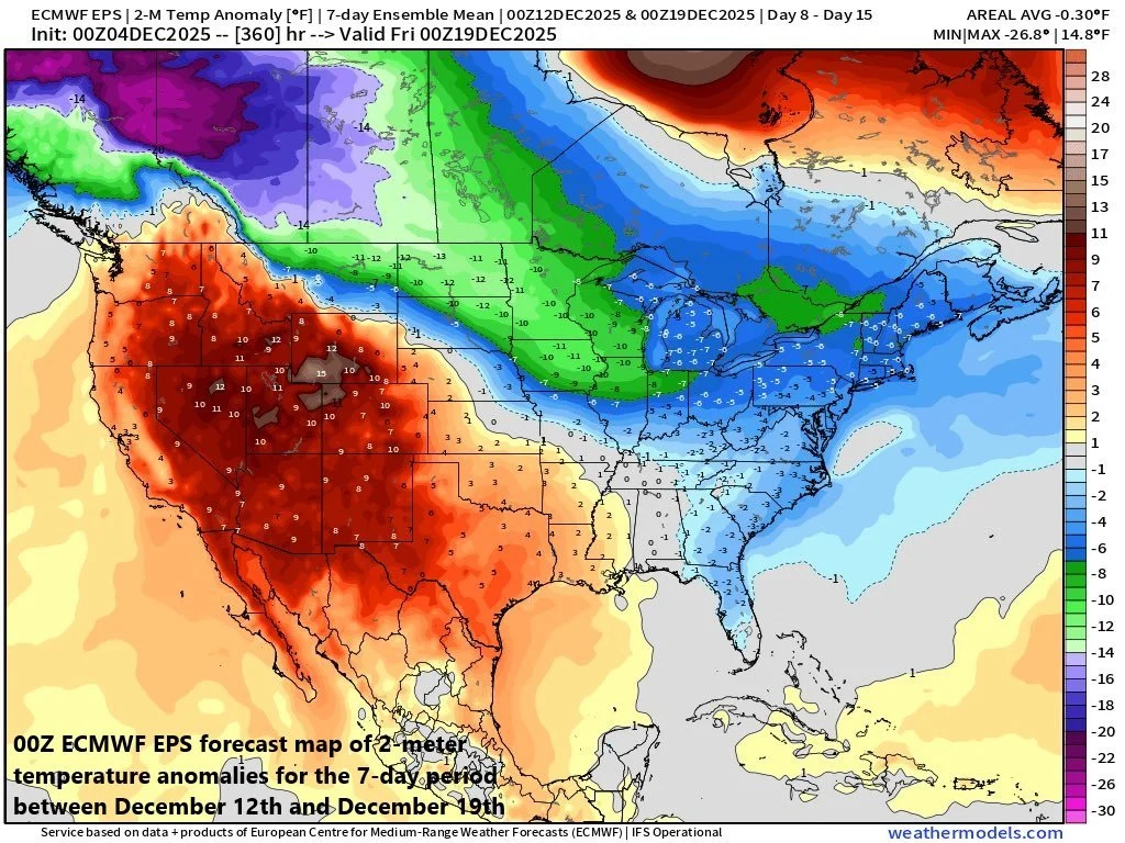
The overall cold weather pattern will continue into at least the middle of the month of December across the Northern Plains, Great Lakes, Mid-Atlantic and Northeast US with numerous additional cold air outbreaks on the table. Map courtesy ECMWF, weathermodels.com
Looking ahead, the Arctic cold will moderate this weekend only to be replenished early next week following the passage of another strong cold front. This late weekend cold front and its associated “clipper” low pressure system may come with some accumulating snow on Sunday night across portions of the Mid-Atlantic (this time the northern half has best chance of snow) and Northeast US. Indeed, the overall cold weather pattern looks like it’ll continue into at least the middle of the month with colder-than-normal conditions on average across the Northern Plains, Great Lakes, Mid-Atlantic and Northeast US.
Meteorologist Paul Dorian
Arcfield
arcfieldweather.com
Follow us on Facebook, Twitter, YouTube
Video discussion: