***The hits just keep on coming...ice, snow Saturday/Saturday Night…accumulating snow later Tuesday into Wednesday with highest amounts southern Mid-Atlantic...other threats to follow***
Paul Dorian

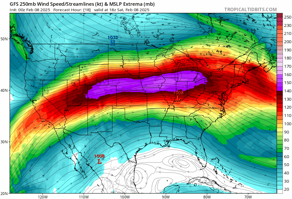
A very active jet stream across the nation during the next week or so will help to contribute to multiple winter storms that will impact the Mid-Atlantic region…ice and/or snow are on the table for each. Maps courtesy NOAA, tropicaltidbits.com
Overview
The hits just keep on coming...
An active weather pattern will bring two more winter storms to the Mid-Atlantic region between the weekend and the early-to-middle part of next week and there will be multiple other threats to follow. Low pressure will ride up along the Appalachian Mountains late Saturday as a secondary system forms off the Mid-Atlantic coastline. The result will be snow, sleet and freezing rain in the Mid-Atlantic region from Saturday into Saturday night with significant icing in some areas . The bulk of Super Bowl Sunday will be dry with no travel issues expected during the afternoon hours leading up time to the game (starts at 6:30pm). Another storm is likely to take more of a southern track early next week compared to recent systems heading directly to the Mid-Atlantic coastline. This next storm system will bring accumulating snow to the Mid-Atlantic from later Tuesday into Wednesday and perhaps significant amounts in places like the Washington, D.C. metro region.

A mixed bag of snow, sleet, and freezing rain is in store for the Mid-Atlantic region from Saturday into early Sunday. It should be cold enough for some snow accumulations on the front end of this weekend event across portions of eastern PA, NYC, and interior NW NJ. Significant icing can take places in many areas of the Mid-Atlantic region before the precipitation winds down early Sunday. Map courtesy NOAA, tropicaltidbits.com
Ice/snow accumulations Saturday/Saturday Night
Low pressure will move east from the Central Plains on Saturday and deepen as it crosses the Ohio Valley by Saturday evening. This “initial” low pressure system will push to the Appalachian Mountains of West Virginia as a “secondary” low pressure area starts to form off the Mid-Atlantic coastline later Saturday night and this one becomes the main player. Precipitation is likely to break out in the DC metro region by late morning or mid-day on Saturday likely as a mix of snow and sleet and there can be a coating of snow in some spots. By later Saturday and Saturday night, the precipitation in DC should be mainly in the form of rain, but sleet can mix in a times, and there still can be some freezing on untreated surfaces with temperatures hanging around the freezing mark right through the night.
Farther to the north, it should be cold enough at the onset for some snow across places like eastern PA, NYC, and interior NW New Jersey - and it can actually come down hard for awhile. Snow and sleet begins in Philly around mid-afternoon and likely a late afternoon start time in NYC. The snow and sleet changes to freezing rain across the Philly metro late today and continues through the night, and there will be an icy buildup on untreated surfaces (e.g., decks, trees) with temperatures at or below freezing. Snow dominates the scene tonight across NYC though sleet/freezing rain can mix in at times.
Snow accumulations of a coating to a couple of inches are possible in the Philly metro with an icy glaze put on top…3-6 inches of snow are on the table for NYC before any changeover to sleet/freezing rain. In all areas of the DC-to-Philly-to-NYC corridor, the precipitation should wind down by early Sunday…watch for an icy glaze in many areas early Sunday before ground-level temperatures climb above freezing. The bulk of the day on Sunday should turn out to be dry with increasing amounts of sunshine and no travel issues are anticipated in the mid-to-late afternoon hours leading up to the Super Bowl which is scheduled to begin at 6:30pm.
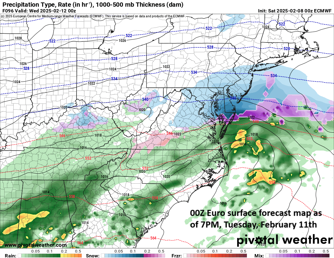
Another low pressure system threatens the Mid-Atlantic region for the early-to-middle part of next week. This storm is likely to take more of a southern track than its predecessors heading directly towards the coastal waters of the Mid-Atlantic. As such, more cold air will be established ahead of its arrival and pushed farther to the south. The result of this will likely be mainly a snow event for most of the Mid-Atlantic region from Tuesday into Wednesday and and snowfall amounts can be significant in some sections (e.g., DC metro). Map courtesy ECMWF, Pivotal Weather
Accumulating snow later Tuesday into Wednesday…significant amounts in some areas (e.g., DC metro)
After the weekend system passes by to the northeast, another cold and dry air mass will push into the Mid-Atlantic region on Sunday and Sunday night...and moisture will not be far behind. It appears that yet another storm system will gather strength during the early part of next week in this ongoing very active weather pattern and this one is likely to take more of a southern route and push directly towards the coastal waters of the Mid-Atlantic. As such, cold air will push farther to the south ahead of this system compared to recent storms and this should result in primarily a snow event in the Mid-Atlantic region. Accumulating snow is likely from later Tuesday into Wednesday and there can significant amounts in some areas such as the Washington, D.C. metro region.

The snow can accumulate to very high amounts over the next couple of weeks; especially, across portions of New England and the interior Northeast US. Map courtesy ECMWF, weathermodels.com
Looking even farther down the road, multiple other systems are likely to follow during the late week and next weekend with more snow, ice and rain on the table for the Mid-Atlantic region as this on-going very active winter weather pattern continues into the second half of February.
Meteorologist Paul Dorian
Arcfield
arcfieldweather.com
Follow us on Facebook, Twitter, YouTube
Video discussion (from Thursday PM):