10:00 AM (Tuesday) - ***Peak of the heat comes today with numerous 100 degree readings likely...back door cool front to soon bring relief...next week looks quite reasonable***
Paul Dorian
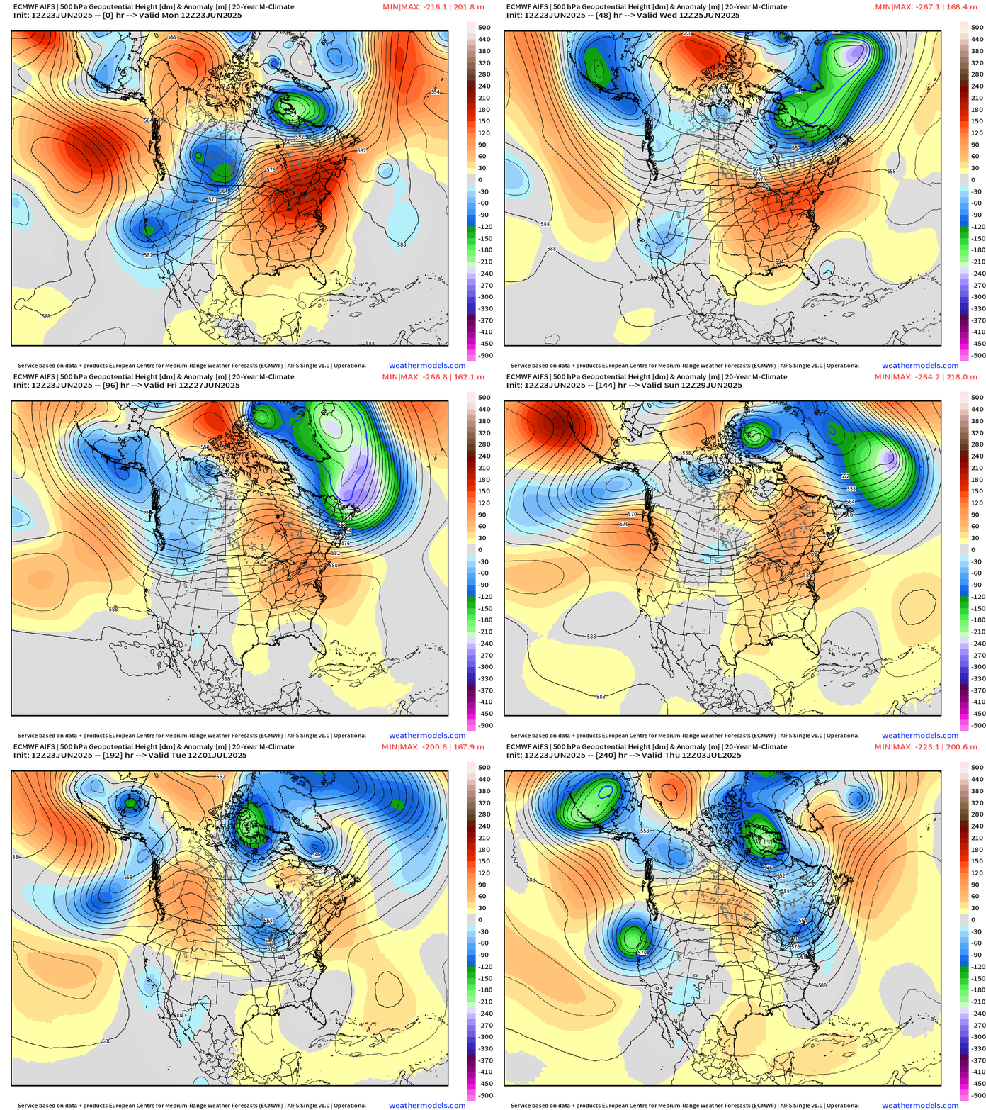
Big time changes are coming to the upper atmosphere during the next week or so with the current very strong ridge of high pressure located over the northeastern states replaced by an upper-level trough of low pressure next week. The end result will be another couple days of intense heat and humidity in the Mid-Atlantic/NE US and then quite a reasonable next week in terms of overall temperatures. Map courtesy ECMWF, weathermodels.com (loop of forecasted 500 mb height anomalies runs from today to Thursday, July 3rd)
Overview
There were some records tied or broken on Monday and a few spots reached the century mark; however, the peak of this current hot spell comes today with numerous 100-degree readings likely all along the DC-to-Boston corridor. In fact, it is possible that 100-degree readings are experienced later today in each state all the way from Maine-to-Florida. In Philadelphia on Monday, temperatures reached 99 degrees which broke the record for the date set just one year ago, and 100 degrees is certainly on the table for this afternoon which would be the first at “PHL” since July of 2012.
There is relief in sight for the Mid-Atlantic region and Northeast US and, in some cases, there can be a dramatic drop in temperatures following the passage of a back door cool front. The overall weather pattern becomes unsettled as well with the chance of showers and thunderstorms returning on Wednesday afternoon and then increasing on Thursday...any thunderstorm that forms on either day can be strong-to-severe. Looking ahead to next week, overall temperatures look quite reasonable for much of the eastern half of the nation as the calendar transitions from June to July.
Today is likely to be the peak of the current heat spell across many northeastern states with numerous 100-degree readings on the table. Map courtesy NOAA, weathermodels.com
Details
The temperature reached 101 degrees on Monday in Newark, NJ (EWR) which broke their daily record and Philly (PHL) topped out at 99 degrees which also set a record for the date. Other high temperature readings on Monday include 98 degrees at Reagan Nation Airport (DCA), 96 degrees at Dulles Airport in Virginia (IAD), 97 degrees at BWI Airport, 94 degrees at La Guardia Airport in NYC, and 96 degrees in Central Park (NYC)which tied their record high. Today is likely to feature numerous 100-degree readings all along the DC-to-Boston corridor as the current heat spell comes to a peak and this would be the highest temperature in several years in some spots. For example, Philly has not reached the century mark since July of 2012 and odds are pretty high for 100+ degrees there later today in my opinion. The century mark may even be reached later today as far north as Boston, Massachusetts which would tie the record on this date set last in 2021.
One of the main culprits of this current hot spell across the northeastern states as a very strong upper-level ridge of high pressure that is currently overhead of the Mid-Atlantic region. This ridge begins to break down on Wednesday – especially across its northern perimeter – and it also tends to shift southward over the next couple of days. At the same time, high pressure builds into southeastern Canada and this combination will allow for the formation of a back door cool front which will push from northeast-to-southwest in coming days. As a result, temperatures will first drop noticeably at mid-week across the state of Maine and then temperatures on Thursday will drop noticeably from Boston to New York City. In fact, the highs on Thursday in Boston could be close to 70 degrees as compared with today’s 100 degrees.
Temperatures can drop dramatically this time of year in the Northeast US following the passage of a back door cool front as low-level winds shift to an east/northeast direction. In Boston, as an example, high temperatures later today are likely to be near 100 degrees and 70-degree highs are possible there on Thursday afternoon following the passage of the cool front. Map courtesy NOAA, tropicaltidbits.com
The cool down extends southwestward by Friday to Philly with a cooler-than-normal day possible there and even DC should feature noticeably lower temperatures to end the work week. The high pressure over southeastern Canada will shift eastward to off the eastern seaboard this weekend which assures very warm and humid conditions across the Mid-Atlantic, but not the intense heat and humidity being experienced right now. Looking ahead, another cool front looks destined to arrive in the eastern states by around Tuesday - the first day of July - and the bulk of the week to follow will likely feature normal-to-below-normal temperatures in much of the eastern US.
The overall weather pattern becomes unsettled again on Wednesday with the returning threat of showers and thunderstorms to the Mid-Atlantic region. That threat of rain will increase on Thursday and there will be a daily shots at showers and thunderstorms in the Friday, Saturday, Sunday time period. Any thunderstorms that forms on either Wednesday or Thursday can be strong-to-severe. Map courtesy Canadian Met Centre, tropicaltidbits.com
The transition from today’s intense heat and humidity to the cooler weather expected later in the week may be accompanied by some strong-to-severe thunderstorm activity. The chance of showers and thunderstorms will return to the Mid-Atlantic region on Wednesday afternoon and then increase on Thursday and any of these storms that form on either of these days can be strong-to-severe. The unsettled weather pattern will continue on Friday, Saturday, and Sunday with a daily shot at some shower/thunderstorm activity.
Meteorologist Paul Dorian
Arcfield
arcfieldweather.com
Follow us on Facebook, Twitter, YouTube
Video discussion:


