
2:00 PM (Wednesday) - ***Back door cool front to break the back of the heat wave...transition to cooler conditions to come with showers and possible strong-to-severe thunderstorms***
Paul Dorian
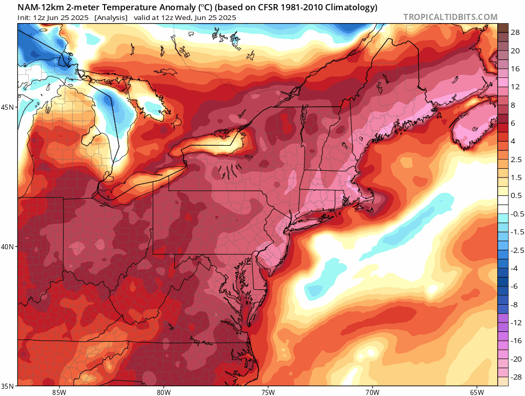
A back door cool front will break the back of this current heat wave from northeast-to-southwest. By Friday, temperatures will be much reduced compared to today in the NYC-to-Philly-to-DC corridor as an ocean flow of air forms on the heels of a back door cool frontal passage. Maps courtesy NOAA, tropicaltidbits.com
Overview
Today will feature high heat and humidity once again in the Mid-Atlantic region and high temperature records for the date are likely to be set in many locations. There is relief on the way, however, thanks to a back door cool front that will push southwestward from northern New England during the next couple of days. Temperatures will be much reduced in the Mid-Atlantic region by Friday afternoon as an ocean flow of air (east-to-northwest winds) develops following the passage of the back door cool front. The transition from today’s high heat and humidity to the cool down at the end of the week will come with scattered showers and thunderstorms and some of the storms can be strong-to-severe.

The surface weather map this evening will feature strong high pressure over southeastern Canada and this will help to promote the formation of a back door cool front which will then move from northeast-to-southwest. Map courtesy NOAA, tropicaltidbits.com
Recap of yesterday’s record-breaking heat in the Mid-Atlantic
The heat wave that became intense on Monday in the Mid-Atlantic region may have reached a peak on Tuesday with numerous 100-degree readings and several record high temperatures set for the date. In Philadelphia, temperatures topped out at 101 degrees which was the first triple digit reading at “PHL” since July 18th, 2012, and the first 101-degree observation since July 7th, 2012. The last 100-degree reading in Philly that took place during the month of June was in 1994 when the high temperature was 100 degrees on the 19th. The hottest June temperature ever recorded in Philly was 102 degrees and it came on June 29th, 1934, during what was arguably the hottest decade ever for much of the nation.
Elsewhere in the Mid-Atlantic region, triple digits were reached yesterday in the following locations: 100 degrees in Reading, PA (RDG), 103 degrees in Newark, NJ (EWR), 101 degrees in Wilmington, DE (ILG), 102 degrees at JFK Airport in NYC, and 102 degrees in Atlantic City, NJ (ACY). The 99 degrees recorded on Tuesday at Reagan National Airport (DCA) fell just short of the daily record and the 99 degrees at Central Park was indeed a record high temperature for the date. Central Park (NY) had reached the 99-degree mark before during the month of June with, for example, back-to-back 99-degree days in early June of 1925.

The transition from today’s intense heat and humidity in the Mid-Atlantic region to much cooler conditions by week’s end will come with scattered showers and thunderstorms…any thunderstorm can reach strong-to-severe levels. Maps by NOAA’s Storm Prediction Center
Back door cool front
One of the main culprits of this current hot spell across the northeastern states is a very strong upper-level ridge of high pressure that is currently overhead of the Mid-Atlantic region. This ridge begins to break down later today and it also begins to shift to the south. At the same time, high pressure builds into southeastern Canada and this combination will allow for the formation of a back door cool front over northern New England that will push from northeast-to-southwest during the next couple of days. As a result, temperatures will first drop noticeably across the state of Maine beginning later today and then temperatures on Thursday will drop noticeably from Boston to New York City. In fact, temperatures on Thursday in Boston and New York City are likely to be peaking in the 70’s following the middle to high 90’s expected later today. The cool down extends southwestward to Philly by Friday with a cooler-than-normal day possible there and even DC should feature noticeably lower temperatures to end the work week; especially, across its northern suburbs.
The high-pressure system that builds over southeastern Canada in the next day or two will shift southeastward to a position off the east coast by the early part of the weekend and the back door cool front that pushes from New England to the southern Mid-Atlantic will turn around and push northward on Saturday as a warm front. As a result, the weekend will turn out to be warmer in the Mid-Atlantic and high temperatures by Sunday and Monday will likely be pushing the 90-degree mark in DC, Philly, and New York City, but the intense heat of the past couple of days is not likely to return anytime soon.
Severe weather threat on the table
The transition from today’s intense heat and humidity to the cooler weather conditions expected later in the week will be accompanied by scattered showers and thunderstorms. In fact, the chance of showers and thunderstorms will return to the Mid-Atlantic region this afternoon after a few days of rain-free weather and the threat of rain/storms will continue tonight and on Thursday. Any thunderstorm that forms during this transition period from later today into Friday can be strong-to-severe...and a word of caution: sometimes extreme heat ends with powerful storms…something we’ll closely monitor during the next 48 hours. The unsettled weather pattern will this weekend in the Mid-Atlantic region with a daily shot at some shower and/or thunderstorm activity...neither day, however, should be total washouts.
Meteorologist Paul Dorian
Arcfield
arcfieldweather.com
Follow us on Facebook, Twitter, YouTube
Video discussion: