
***Unsettled pattern next couple days in the Mid-Atlantic with the risk of strong-to-severe thunderstorms...torrential rainfall, damaging wind gusts on the table both days...4th of July looks nice***
Paul Dorian
Overview
A strong surface cold front will combine with an upper-level trough and entrenched heat and humidity to raise the chance of strong-to-severe thunderstorm activity later Tuesday into Tuesday night. Map courtesy NOAA, tropicaltidbits.com
There was a break in the action on Sunday across the northern Mid-Atlantic region, but strong thunderstorms hit many spots across southern sections to close out the last weekend of June. The threat of showers and thunderstorms will become quite high throughout the entire Mid-Atlantic region from this afternoon into tonight, and this threat will continue Tuesday and Tuesday night...both time periods will come with the risk of strong-to-severe thunderstorms. The combination of a stationary front that turns around later today and pushes northward as a warm front, and the approach of a cold front later tomorrow will keep it unsettled around here, and any thunderstorm on either day can produce torrential rainfall and damaging wind gusts. High pressure pushes in for the mid-week and then a weak cold front comes through late Thursday paving the way for a very nice Independence Day holiday on Friday featuring plenty of sunshine in the Mid-Atlantic region, lower humidity levels, and comfortably warm conditions.

Overall humidity will be quite high later today into tonight across the Mid-Atlantic region following the passage of a warm front and this can set the stage for downpours associated with any thunderstorm activity. Map courtesy NOAA, tropicaltidbits.com
Details
Parts of the Mid-Atlantic region made it through the day on Sunday with no rainfall, but the threat of showers and thunderstorms will become quite high once again for the entire area from this afternoon into tonight and remain quite high from later tomorrow into tomorrow night. A stalled-out frontal system across the southern half of the region will turn around this afternoon and push slowly to the north as a warm front and then a cold front will approach the area from the northwest later Tuesday. With the Mid-Atlantic region fully in the warm sector by later today, temperatures should soar to near 90 degrees for afternoon highs all along the DC-to-Philly-NYC corridor and humidity levels will become quite oppressive.
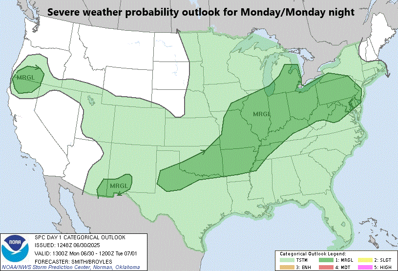
Severe thunderstorms are a threat on Monday afternoon and evening in the zone from the Middle Mississippi Valley to the Mid-Atlantic with torrential rainfall and damaging wind gusts on the table. Map courtesy NOAA/SPC
The atmosphere will destabilize this afternoon as shear increases with mid-level flow strengthening ahead of an upper-level trough. As a result, numerous showers and thunderstorms are very likely to form this afternoon and any storm can reach strong-to-severe levels with the potential of “downburst-producing” damaging wind gusts. In addition, with high moisture levels in the atmosphere and the likely rather slow-movement of these developing thunderstorm cells, there can be torrential rainfall in some spots potentially leading to localized flash-flooding conditions. Thunderstorm activity should last into the late evening hours and then diminish in the overnight hours as any uplift from daytime heating fades away.
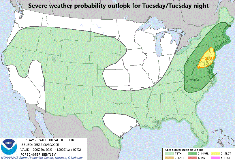
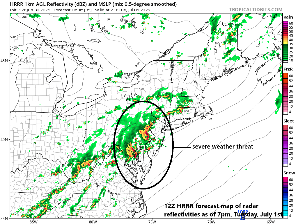
Severe thunderstorms are a threat on Tuesday afternoon and evening in the DC-to-Philly-to-NYC corridor as a cold front drops southeastward into the Mid-Atlantic region. Map courtesy NOAA/SPC
On Tuesday, a “conventional” surface cold front will approach the Mid-Atlantic region from the northwest (last week’s “back door” cold front moved from northeast-to-southwest). In addition, an upper-level trough will shift eastward into the Mid-Atlantic region, intensify some, and enhance upward motion all along the I-95 corridor. Given the combination of these systems and the entrenched heat and humidity in the region, showers and thunderstorms will likely reform by the afternoon hours on Tuesday. There is the possibility that some of the thunderstorms that form later tomorrow will reach strong-to-severe levels with downpours (and the threat of localized flash-flooding), damaging wind gusts, and even isolated tornadoes are on the table in the DC-to-Philly-to-NYC corridor. This next severe weather threat should come to an end later tomorrow night in most areas of the Mid-Atlantic; however, coastal sections of New Jersey and the Delmarva Peninsula could see activity hanging on into the early morning hours of Wednesday.
At mid-week, high pressure will take control of the weather in the Mid-Atlantic region and sunshine, warm conditions should dominate the scene. A weak cold front will then drop southeastward through the northeastern states on Thursday, and it can produce isolated showers in the Mid-Atlantic region, but it likely does not produce any strong thunderstorm activity for the area. Following the passage of the weak cold front late Thursday, the Independence Day holiday on Friday might just turn out to be quite spectacular in the Mid-Atlantic region with plenty of sunshine, low humidity, and comfortably warm conditions and that nice weather should last into at least the first part of the upcoming weekend.
Meteorologist Paul Dorian
Arcfield
arcfieldweather.com
Follow us on Facebook, Twitter, YouTube
Video discussion: