Wed. PM - **Atmosphere about to "re-ignite"...another round of showers and thunderstorms on the way with flooding downpours on the table (again)...break in the humidity from Friday into Saturday**
Paul Dorian

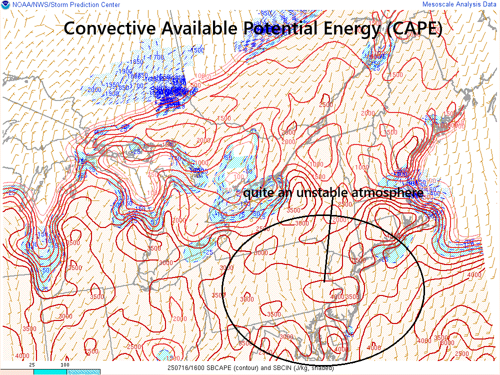
One measure of atmospheric instability is known as the “Convective Available Potential Energy (CAPE)” and it is quite high in the Mid-Atlantic region raising the chance of flooding downpours and strong-to-severe thunderstorm activity. Map courtesy NOAA/SPC
Overview
The combination of a tropical air mass, a stalled-out frontal boundary zone, and an upper-level disturbance will “re-ignite” the atmosphere this afternoon and the result is very likely to be yet another round of heavy showers and strong thunderstorms for much of the DC-to-Philly-to-NYC corridor. With the likelihood of flooding downpours and the well saturated grounds, flash flood watches have been issued throughout the Mid-Atlantic region by the National Weather Service. This stalled-out front system will turn around by tomorrow and push to the north as a warm front and the heat and humidity should reach a peak in the afternoon with highs up in the 90’s in many places. A cold front then pushes through the northern Mid-Atlantic region later Thursday night into early Friday and it then stalls out across the southern Mid-Atlantic later in the day. As a result, the corridor from Philly to New York City will see a big break in the humidity on Friday, Friday night, and much of Saturday, but the stalled-out front will keep it unsettled and moderately humid in and around the DC metro area. The humidity does build back up again throughout the Mid-Atlantic region for the second half of the weekend and the chance of showers and thunderstorms will also make a return.
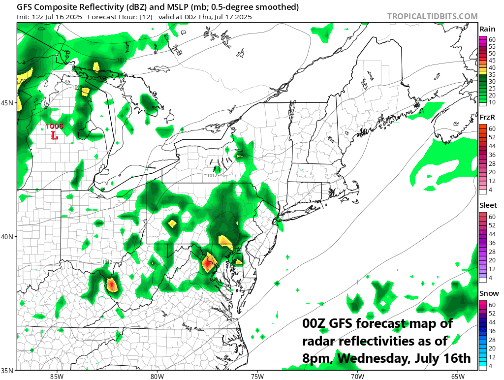
Showers and thunderstorms are likely in much of the I-95 corridor during the 5-midnight time period and flooding downpours are on the table. Map courtesy NOAA, tropicaltidbits.com
Details
Here we go again...the atmosphere is very moist and quite unstable and the arrival of an upper-level “short-wave” this afternoon will be the catalyst for the development of clusters of showers and thunderstorms. These showers and thunderstorms will first form across the central and western Mid-Atlantic regions and then slide slowly east to the DC-to-Philly-to-NYC corridor with a timetable in the I-95 corridor from around 5pm to midnight (an isolated shower or thunderstorm possible beforehand). Given the entrenched high humidity and the expectation of strengthening upward motion, heavy downpours will once again be on the table and flash-flooding will be of high concern. Any thunderstorm that forms later today can produce an inch or two of rainfall in just an hour or so and local amounts of 3-4 inches are certainly on the table in parts of the Mid-Atlantic region.

Flash-flooding is on the table once again with another round of showers and thunderstorms on the way to the DC-to-Philly-to-NYC corridor. Map courtesy NOAA/SPC
The stalled-out frontal system that plays an important role in the destabilization of the atmosphere later today will turn around and advance northward as a warm front by later tonight and early Thursday. On the back side of the warm front, Thursday afternoon is likely to see the peak of the heat and humidity for the week with many spots featuring high temperatures up in the 90’s. The next front to deal with will be a strong cold front that crosses the northern Mid-Atlantic region from later tomorrow night into early Friday and then stalls out in the southern Mid-Atlantic later Friday.

Much more comfortable conditions are headed to at least the northern Mid-Atlantic region (e.g., Philly, NYC) for the Friday into Saturday time period…humidity will rise again quite noticeably for the second half of the weekend. Map courtesy NOAA, tropicaltidbits.com
Much more comfortable air with lower humidity will push into the northern Mid-Atlantic region on Friday (e.g., Philly, NYC), but the stalling front is likely to get hung up in the southern Mid-Atlantic near the Washington, D.C. metro so any improvement there will be somewhat muted. In fact, the threat of showers and thunderstorms will continue on Friday, Friday night, and Saturday in the DC metro area whereas Philly and NYC are likely to be rain-free. All portions of the Mid-Atlantic will see a rise in overall humidity for Saturday night and Sunday and there will be the threat of showers and thunderstorms all along the DC-to-Philly-NYC corridor. Another cold front is likely to then cross the Mid-Atlantic region on Sunday night paving the way for a comfortably warm start to the new week along with low humidity. One final note, there continues to be no intense heat in sight for the northeastern part of the country.
Meteorologist Paul Dorian
Arcfield
arcfieldweather.com
Video discussion: