
*Unsettled weather returns this weekend and next week’s pattern with northwest flow aloft could produce “mesoscale convective complexes”...a pleasant start to August is on the table*
Paul Dorian

Temperatures could be below-normal across much of the eastern half of the nation as we begin the month of August next Friday. Map courtesy NOAA, tropicaltidbits.com
Overview
The last few days have been relatively quiet in the Mid-Atlantic region with dry and warm conditions dominating the scene. Heat and humidity will build up later in the week and an approaching frontal system could lead to showers and thunderstorms by Friday night. That front will stall-out nearby this weekend and likely result in a shower and thunderstorm threat on both weekend days.
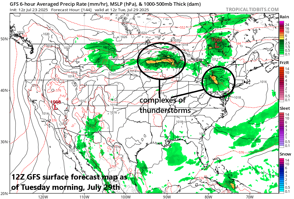
The upper-level pattern next week will feature strong high pressure ridging over the south-central states and a northwest flow of air from the Great Lakes to the Northeast US. This kind of pattern sometimes produces complexes of thunderstorms that travel in the northwest flow from the Great Lakes/Midwest to the Mid-Atlantic/Northeast US...something to monitor during the next several days. Looking ahead, there are signs that a strong upper-level trough may become positioned over southeastern Canada at the end of next week potentially bringing a pleasant start to the month of August.
Details
The moderate conditions of the past few days in the Mid-Atlantic region will give way to a buildup of heat and humidity on Thursday and then high heat for the day on Friday with afternoon highs in the mid-to-upper 90’s all along the DC-to-Philly-to-NYC corridor. A frontal system will approach the area from the northwest on Friday night increasing the chances of showers and thunderstorms as we close out the work week.
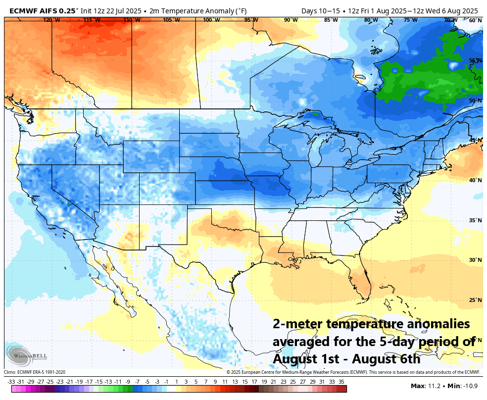
2-meter temperatures during the first five days of August are forecasted to average at below-normal levels across a large part of the nation. Map courtesy ECMWF, Weather Bell Analytics (Meteorologist Joe Bastardi, X)
That front will stall-out nearby this weekend leading to an unsettled weather pattern and the chance of showers and thunderstorms on both days to go along with very warm and humid conditions. BY the early part of next week, strong high pressure ridging in the upper part of the atmosphere will begin to “retrograde” to the west and it’ll become positioned over the middle of the country by mid-week. With this re-positioning, the flow aloft will be from the northwest from the Great Lakes/Midwest into the northeastern states. This kind of upper-level pattern sometimes results in complexes of thunderstorms that develop over the Upper Midwest/Great Lakes which could eventually wind up in the Mid-Atlantic or Northeast US riding along in the northwest flow of air. The threat for one or more of these “mesoscale convective complexes” will need to be assessed as we head through the weekend and into the first part of the new week.

A teleconnection index known as the Pacific-North American (PNA) is forecasted to push into positive territory late in July into early August and this is often a sign of cooler-than-normal conditions coming to the northeastern states. Plot courtesy ECMWF, Weather Bell Analytics, Meteorologist Tony Pann, X
By later next week, an upper-level trough of low pressure may intensify over the southeastern part of Canada, and it would likely feature a cooler-than-normal air mass. In fact, there are signs that this pattern could bring about a cooler-than-normal start to the month of August in the Mid-Atlantic region which begins next Friday. Some supporting evidence for this potentially pleasant start to the month of August in the northeastern states comes from a teleconnection index known as the Pacific-North American (PNA) which is predicted to push into positive territory right around the time the calendar flips from July to August. The positive phase of the PNA generally features higher pressure over the western part of North America and lower-than-average pressure across much of the eastern states along with cooler-than-normal conditions.
Meteorologist Paul Dorian
Arcfield
arcfieldweather.com
Follow us on Facebook, Twitter, YouTube
Video discussion: