****Heavy rain, strong-to-severe storms, significant flash flooding...all on the table this afternoon and tonight...much cooler to start the month of August...a great weekend on the way****
Paul Dorian

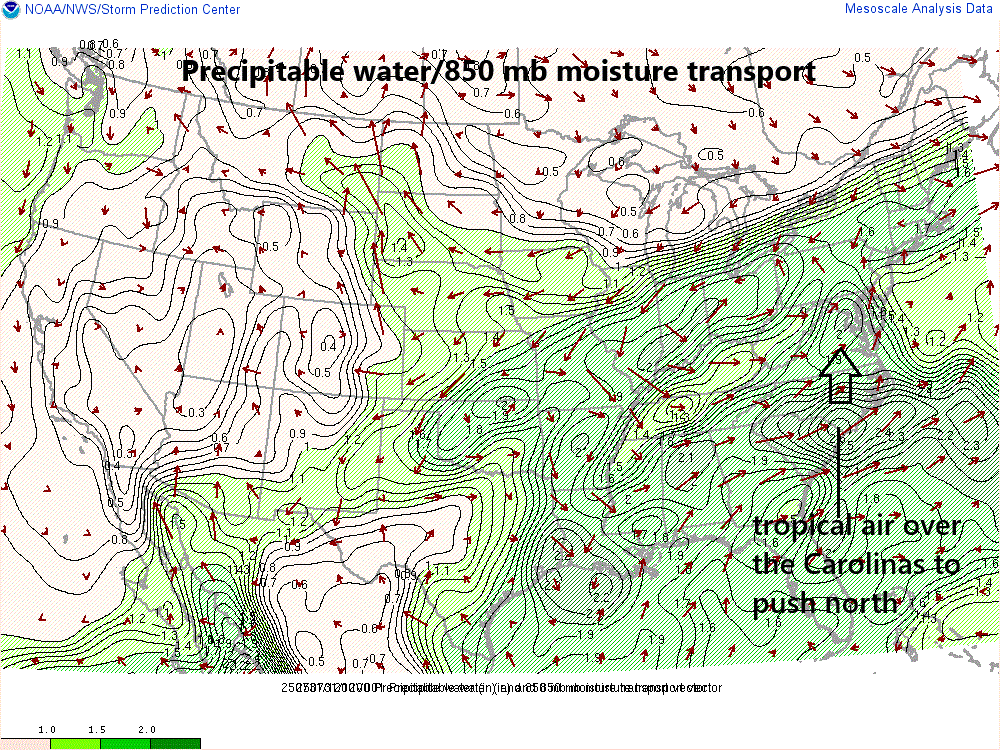
Moisture levels are already quite high in the Mid-Atlantic region and they are likely to climb even higher later in the day as some truly tropical air now centered over the Carolinas is transported to the north in a south-to-north low level flow. As the slowly advancing cold front from the north and west interacts with this very humid air mass, widespread showers and thunderstorms are sure to follow with torrential rainfall on the table. Map courtesy NOAA
Overview
A major-league cool-down is coming to the Mid-Atlantic region and the transition from the high heat and humidity to the well below-normal temperatures will come with heavy rainfall, strong-to-severe thunderstorms, and localized flash flooding. A slow-moving cold frontal system will approach the area later today from our north and west, but then only be able to inch its way through the Mid-Atlantic region during the next 24 hours as low pressure forms along its boundary zone. Widespread showers and thunderstorms are likely from early this afternoon into the late-night hours and total rainfall amounts can end up being excessive in some spots raising the concern for potentially significant flash flooding. Much cooler air moves in on Friday on the back side of the slowly departing cold front and low pressure system and we are setting up for one of the nicest weekends of the summer season with very comfortable temperatures and humidity levels.

The nationwide “weather warnings” map issued by NOAA this morning features lots of “Flash Flood Watches” across the Mid-Atlantic and southern New England (shown in green). Map courtesy NOAA/WPC
Details
Ingredients are falling into place for an excessive rainfall event in the Mid-Atlantic region from this afternoon into early Friday. A slow-moving cold front will advance into an extremely humid air mass and low pressure will form along the frontal boundary zone. In addition, an extremely strong jet streak across southern Canada will help to enhance upward motion in the region. Widespread showers and thunderstorms are likely from early this afternoon into the late-night hours as the front slowly edges its way to the south and east. The atmosphere is already very moist ahead of the frontal system and tropical air (even more moist) now centered over the Carolinas will feed in from the south later in the day.

Flash flooding is a big concern for later today and tonight; especially, along the immediate I-95 corridor region from DC-to-Philly-to-NYC (shown in red). Map courtesy NOAA/WPC
Overall wind flow in the lower and middle parts of the atmosphere will run roughly parallel to the frontal boundary zone which supports the idea that “training” and/or “back-building” convection may take place...in other words, multiple heavy shower cells and thunderstorms can ride over the same locations during this event). Rainfall amounts will likely average 1-3 inches by early Friday morning in much of the Mid-Atlantic region; however, as much as 3-6 inches is on the table for some spots that do experience the “training” or “back building” of convection. While flash flooding is the main threat from today’s thunderstorms, there can be localized “downdraft-driven” damaging wind gusts in some areas as well. In addition, an isolated tornado or two cannot be ruled out; especially, across the southern Mid-Atlantic region from southern PA-to-MD/VA-to the Delmarva Peninsula.
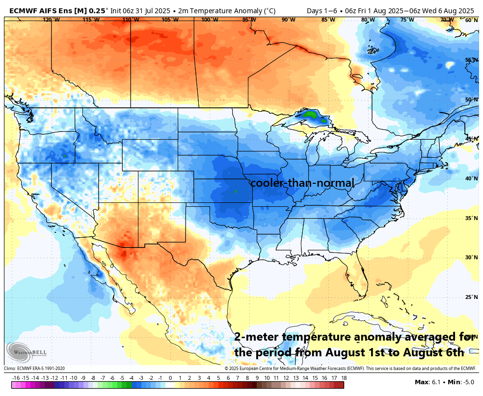
Much cooler air moves into the Mid-Atlantic region on Friday and the first week of August looks cooler-than-normal across a large part of the nation (shown in blue). Map courtesy ECMWF, Weather Bell Analytics
On Friday, low pressure will slowly pull away from the east coast and there will be mostly cloudy skies and lingering showers in much of the immediate I-95 corridor region and especially along coastal sections. In addition, the first day of the new month will feature well below-normal temperatures and a stiff east-to-northeast wind that will develop in a counter-clockwise fashion around the departing low pressure system. Clearing skies should develop on Friday night and the weekend is likely to turn out to be one of the nicest of the entire summer season with very comfortable temperatures and low humidity levels…but between now and then, it could get pretty ugly.
Meteorologist Paul Dorian
Arcfield
arcfieldweather.com
Follow us on Facebook, Twitter, YouTube
Video discussion: