
***Strong-to-severe thunderstorm threat late today/early tonight in much of the Mid-Atlantic region...flooding downpours again possible***
Paul Dorian

Strong storms can impact the I-95 corridor by the end of the day or early tonight; especially, in the southern half of the Mid-Atlantic (e.g., DC, Philly). Map courtesy NOAA, tropicaltidbits.com
Overview
In general, it is much the same story as yesterday in the Mid-Atlantic region as far as the weather is concerned with the chance of late afternoon and early evening strong-to-severe thunderstorms along with possible flooding downpours. One minor difference from yesterday will be perhaps a bit later arrival time for the storms in the I-95 corridor as we’re looking at the late afternoon or early evening hours in many spots. Like yesterday, the ingredients are there for strong-to-severe thunderstorm activity and possible downpours including an upper-level trough, a slow-moving surface frontal system, and a humid air mass. The unsettled weather pattern continues from tomorrow through the upcoming weekend with a daily shot at showers and thunderstorms and much of next week looks unsettled as well.

Thunderstorms are expanding over West Virginia at this hour and will impact the I-95 region by day’s end or during the evening hours. The best chance of getting hit by this cluster of storms will be in the southern half of the Mid-Atlantic region from SE PA to southern NJ to DC/Delmarva Peninsula. Image courtesy NOAA, College of DuPage
Details
Thunderstorms are starting to intensify and widen in coverage early this afternoon across West Virginia and these cells are heading east-to-northeast towards the I-95 corridor with a likely arrival time of late afternoon or early evening. The atmosphere will destabilize through the day with strong surface heating combining with an approaching upper-level shortwave. Given the already well-saturated grounds and high moisture levels in the atmosphere, the concern for flash flooding remains high in the I-95 corridor with the threat of additional heavy rainfall.
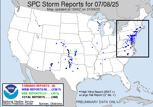
Powerful storms that pushed through the region late yesterday were accompanied by numerous damaging wind reports (markers in blue). While there were “tornado warnings” as this line of storms came through the area, so far there have been no confirmed tornado reports. Map courtesy NOAA/SPC
The upper-level trough and surface frontal system that are playing roles in today’s storm threat will hang around on Thursday and there certainly can be another round of showers and thunderstorms. In fact, not only does the overall weather pattern look unsettled right through the upcoming weekend, but much of next week as well can feature a daily threat of showers and thunderstorms...no need to do any watering.
Meteorologist Paul Dorian
Arcfield
arcfieldweather.com