
**Cooler-than-normal air mass dominating the scene across a large part of the nation...origins in the Arctic...another widespread chilly air outbreak next week...pattern has been quite dry as well**
Paul Dorian

Cooler-than-normal conditions exist today virtually from coast-to-coast. This air mass had its origins in the Arctic region and it looks like there will be another impressive outbreak of chilly air later next week. Map courtesy NOAA, tropicaltidbits.com
Overview
The month of August has been quite kind in many parts of the nation with numerous cooler-than-normal air masses dropping into the US from Canada. A strong cold front pushed off the east coast earlier this week and set the stage for widespread cooler-than-normal conditions here at midweek that extend virtually from coast to coast. This air mass had its origins in the Arctic region and has resulted in more than one hundred tied or broken daily low temperature records on Wednesday and in Atlanta, Georgia, the low temperature today was 55 degrees which tied their monthly low temperature record. I expect to see another large number of stations on Thursday morning with record or near record low temperatures in the eastern US.
Looking ahead, the pattern will repeat later next week with another much cooler-than-normal air mass dropping into the US from Canada bringing a refreshing cool start to the month of September across the eastern half of the nation. This pattern has also been quite dry in parts of the nation including the Mid-Atlantic region and the next several days don’t offer much hope with respect to the chances of some soaking rainfall.

There were more than one hundred record low temperatures either tied or broken earlier today in this widespread chilly air outbreak including the low temperature of 55 degrees in Atlanta, Georgia which tied their lowest temperature for the month of August. I expect to see another large number of stations on Thursday morning with record or near record low temperatures in the eastern US. Map courtesy coolwx.com, NOAA, BAM Weather (X)
Details
A cooler-than-normal air mass for late August that had its origins in the Arctic region extends today across a large part of the nation with more than one hundred daily low temperature records tied or broken across the eastern half of the nation (data source BAM Weather, X). I expect to see another large number of stations on Thursday morning with record or near record low temperatures in the eastern US. Even the Deep South is experiencing this unusual chill for late August with, for example, a low temperature record of 57 degrees set this morning in Birmingham, Alabama (old record was 58 degrees set in 1968; data courtesy James Spann, X). In addition, Atlanta, Georgia bottomed out at 55 degrees this morning not only breaking the daily low temperature record, but matching their low temperature record for the month of August (occurred twice before).

The upper-air pattern of recent days favored the movement of this widespread cooler-than-normal air mass from the Arctic region into the eastern US. map courtesy NOAA, Ben Noll (X/Washington Post)
In the Mid-Atlantic region, temperatures have been running at below-normal levels as well with the upper 40’s in many spots earlier today including, for example, some of the northwestern suburbs of Philly (Nottingham 47 degrees, Kennett Square 49 degrees; data courtesy @ChescoWx, X). For the month, temperatures have been below-normal in the DC-to-Baltimore-Philly-to-NYC I-95 corridor with an average of -3.1 degrees at DCA, -2.5 degrees at BWI, -1.3 degrees at PHL, and -1.6 degrees in Central Park (NYC). The last time Baltimore had a cooler-than-normal month of August was in 2017 (source Tony Pann, X). The last 90-degree day officially observed at Washington’s Reagan National Airport (DCA) took place ten days ago on August 17th and there are no 90-degree days in sight. If August 17th were to end up being the last 90-degree day of the summer season in D.C., it would fall within the top ten of the “earliest” last 90-degree days (source Capital weather Gang, X). One final note on the current chill in the Mid-Atlantic region, the coldest spot in the continental US this morning was Canaan Valley, West Virginia where temperatures bottomed out at 28 degrees (just 3 degrees away from their all-time low for the month).

This cooler-than-normal weather pattern has also been drier than normal in much of the Mid-Atlantic region and there is not a lot of rain predicted for the next week or so. In fact, this is likely to turn out to be the driest August ever recorded at Washington’s Reagan National Airport (DCA) with only 0.20 inches of rain. Map courtesy ECMWF, Pivotal Weather; data source on DC info from Capital Weather Gang (X, Washington Post)
The pattern that has brought cooler-than-normal conditions this month to the Mid-Atlantic region has also been quite dry. In fact, the Washington D.C. metro region has only received 0.20 inches of rain this month, which is more than likely going to end being the driest August on record at DCA. Last fall featured some very dry stretches of weather in the Mid-Atlantic region with virtually no rain at all in Philly (PHL) for the full month of October.
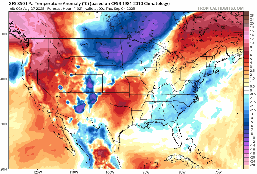
Another widespread much cooler-than-normal air mass is in store later next week which will drop into the US from central Canada. Maps courtesy NOAA, tropicaltidbits.com
Looking ahead to next week, it appears another widespread much cooler-than-normal air mass will drop into the US from Canada. This next chilly shot of air will first arrive in the Northern Plains at mid-week and then likely reach the Mid-Atlantic/Northeast US by the end of next week. By the way, this kind of an upper-level weather pattern would likely bring some brutal cold into the eastern states if it were December or January; however, in August and September, it is rather refreshingly cool. The dry part of the weather pattern will continue across the eastern states into the middle of next week, but there is some hope that this next cold frontal system could bring some beneficial rainfall to the Mid-Atlantic/Northeast US.
Meteorologist Paul Dorian
Arcfield
arcfieldweather.com